| Reference: | S27944 |
| Author | Gerard DE JODE |
| Year: | 1578 ca. |
| Zone: | Wirtenberg & Bavaria |
| Printed: | Antwerpen |
| Measures: | 520 x 370 mm |
| Reference: | S27944 |
| Author | Gerard DE JODE |
| Year: | 1578 ca. |
| Zone: | Wirtenberg & Bavaria |
| Printed: | Antwerpen |
| Measures: | 520 x 370 mm |
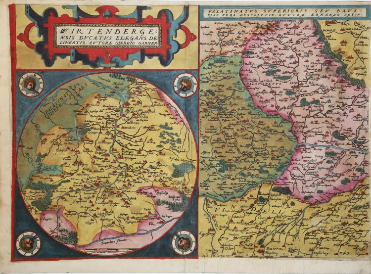
Etching with engraving, before 1573. Exemple of the first edition published in 1578.
Magnificent impression, with great contemporary coloring, with margins, in perfect condition.
Latin text and page number in roman font, XX.
Gerard de Jode, was a cartographer, engraver, printer and publisher in Antwerp, active around the same period of Ortelius. In 1547 he obtained the privilege for the publishing business, but was never able to represent a real threat to his business rival. Ironically, he published a major rival of the Globe, in eight sheets, in 1564. His most important atlas, Speculum Orbis Terrarum, now extremely rare, could not be released until 1578, ie eight years after the Theatrum Orbis Terraum of Ortelius, who had obtained a monopoly for the Cartographic Publishing Antwerp.
The maps of De Jode were finely translated copper in typical Flemish brothers Joannes and Lucas van Doetecum, the best engravers of maps of the time. On the death of Gerard, the son Cornelis published in 1593, a reprint of the atlas increased .
|
Gerard de Jode, born in Nijmegen, was a cartographer, engraver, printer and publisher in Antwerp, issuing maps from 1555 more or less in the same period as Ortelius. He was never able to offer very serious competition to his more businesslike rival although, ironically, he published Ortelius's famous 8-sheet World Map in 1564.
His major atlas, now extremely rare, could not be published until 1578, eight years after the Theatrum, Ortelius having obtained a monopoly for that period. The enlarged re-issue by his son in 1593 is more frequently found. On the death of Cornelis, the copper plates passed to J. B. Vrients (who bought the Ortelius plates about the same time) and apparently no further issue of the atlas was published: however, at least one further issue of the Polar Map, c.1618, is known.
Son of Gerard de Jode, who was a cartographer, engraver, printer and publisher in Antwerp, issuing maps from 1555 more or less in the same period as Ortelius.
Gerard de Jode's major atlas, now extremely rare, could not be published until 1578, eight years after the Theatrum, Ortelius having obtained a monopoly for that period. The enlarged re-issue by his Cornelis in 1593 is more frequently found.
On the death of Cornelis, the copper plates passed to J. B. Vrients (who bought the Ortelius plates about the same time) and apparently no further issue of the atlas was published: however, at least one further issue of the Polar Map, c.1618, is known.
|
|
Gerard de Jode, born in Nijmegen, was a cartographer, engraver, printer and publisher in Antwerp, issuing maps from 1555 more or less in the same period as Ortelius. He was never able to offer very serious competition to his more businesslike rival although, ironically, he published Ortelius's famous 8-sheet World Map in 1564.
His major atlas, now extremely rare, could not be published until 1578, eight years after the Theatrum, Ortelius having obtained a monopoly for that period. The enlarged re-issue by his son in 1593 is more frequently found. On the death of Cornelis, the copper plates passed to J. B. Vrients (who bought the Ortelius plates about the same time) and apparently no further issue of the atlas was published: however, at least one further issue of the Polar Map, c.1618, is known.
Son of Gerard de Jode, who was a cartographer, engraver, printer and publisher in Antwerp, issuing maps from 1555 more or less in the same period as Ortelius.
Gerard de Jode's major atlas, now extremely rare, could not be published until 1578, eight years after the Theatrum, Ortelius having obtained a monopoly for that period. The enlarged re-issue by his Cornelis in 1593 is more frequently found.
On the death of Cornelis, the copper plates passed to J. B. Vrients (who bought the Ortelius plates about the same time) and apparently no further issue of the atlas was published: however, at least one further issue of the Polar Map, c.1618, is known.
|