
| Reference: | S27948 |
| Author | Gerard DE JODE |
| Year: | 1570 ca. |
| Zone: | Danube |
| Printed: | Antwerpen |
| Measures: | 500 x 340 mm |
| Reference: | S27948 |
| Author | Gerard DE JODE |
| Year: | 1570 ca. |
| Zone: | Danube |
| Printed: | Antwerpen |
| Measures: | 500 x 340 mm |
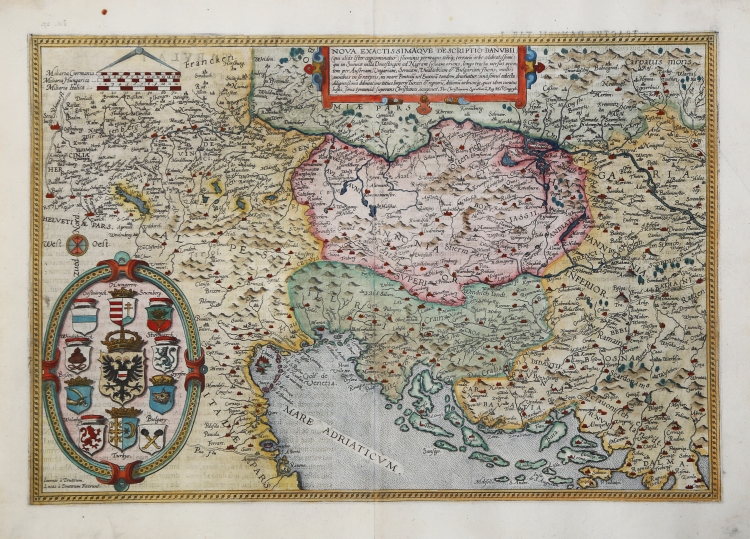
Nova exactissimaque descriptio Danubii (qui alias Ister cognominatur) fluminis permagni totoque terrarum orbe celebratissimi... per Christianum Sgrothonuma.tl Geogrph.
Rare map of the course of the Danube by Gerard de Jode, printed in Antwerp about 1570. Example from the second edition of De Jode's atlas, edited by his son Cornelis and called Speculum Orbis Terrae, 1593. Latin text on verso and page number 27.
The sheet depicts only the western part of the Danube's course. The map was drawn by Christian Sgrooten and is engraved by the Doetecum brothers, whose signature appears on the plate at lower left Ioannes a Deutecu, Lucas a Deutecum fecerunt. The territory depicted is between the sources of the Danube and the confluence of the Drava into it; it includes Friuli, Slovenia, Austria, Croatia, Serbia and Bosnia.
Gerard de Jode was a celebrated engraver and printer, a native of Nijmegen in 1509. After studying mathematics and cosmography, he learned the art of engraving, was for some time at the court of Charles V in Brussels, then moved to Antwerp, where as early as 1551 he began to print artistic engravings by Franz Huys, Martin de Vos, Corneille de Cort, etc. ; but soon specialized in map engraving and printed in Antwerp the famous world map of Giacomo Gastaldi, in 1568 Italy by the same, then other maps by many authors, including Italians, in 1564 a large world map by Abraham Ortelius (Nova totius Terrarum Orbis iuxta neotericorum traditionem descriptio) and finally in 1578 a full-fledged atlas with the title Speculum Orbis Terrarum, in 65 plates, by different authors, already partly published in isolation. It is one of the earliest modern atlases (preceded only by Ortelius' Theatrum), which is extremely rare today. In the last years of his life he waited to prepare maps of the individual continents, large in size, which were perhaps later published, like a great world map, by his son Cornelius. The latter, born in Antwerp in 1568, continued his father's work with much sagacity; in 1589 he published a world map, in 1593 a new edition of the Speculum, enlarged, in 109 maps, and in 1596 an Introductio geographica in tabulas Europae, Asiae, Africae et Americae; the plates, alluded to here, are probably those prepared by his father and of which his son took care of the printing; they have not, however, come down to us. Cornelius then traveled extensively in the Nordic countries and also in Spain. Returning to his homeland, he died in Mons on October 17, 1600.
Etching, finely hand-colored, in perfect condition.
Bibliografia
New Hollstein, Doetecum III, no. 586; Koeman III, 1110; Ortroy S. 126, no. 98: Karrow 70/17, Szathmáry 84/B.
Gerard DE JODE (Nijmegen1509 - Anversa 1591)
|
Gerard de Jode, born in Nijmegen, was a cartographer, engraver, printer and publisher in Antwerp, issuing maps from 1555 more or less in the same period as Ortelius. He was never able to offer very serious competition to his more businesslike rival although, ironically, he published Ortelius's famous 8-sheet World Map in 1564.
His major atlas, now extremely rare, could not be published until 1578, eight years after the Theatrum, Ortelius having obtained a monopoly for that period. The enlarged re-issue by his son in 1593 is more frequently found. On the death of Cornelis, the copper plates passed to J. B. Vrients (who bought the Ortelius plates about the same time) and apparently no further issue of the atlas was published: however, at least one further issue of the Polar Map, c.1618, is known.
Son of Gerard de Jode, who was a cartographer, engraver, printer and publisher in Antwerp, issuing maps from 1555 more or less in the same period as Ortelius.
Gerard de Jode's major atlas, now extremely rare, could not be published until 1578, eight years after the Theatrum, Ortelius having obtained a monopoly for that period. The enlarged re-issue by his Cornelis in 1593 is more frequently found.
On the death of Cornelis, the copper plates passed to J. B. Vrients (who bought the Ortelius plates about the same time) and apparently no further issue of the atlas was published: however, at least one further issue of the Polar Map, c.1618, is known.
|