| Reference: | S33904 |
| Author | Jodocus HONDIUS |
| Year: | 1606 ca. |
| Zone: | Provence |
| Printed: | Amsterdam |
| Measures: | 515 x 360 mm |
| Reference: | S33904 |
| Author | Jodocus HONDIUS |
| Year: | 1606 ca. |
| Zone: | Provence |
| Printed: | Amsterdam |
| Measures: | 515 x 360 mm |
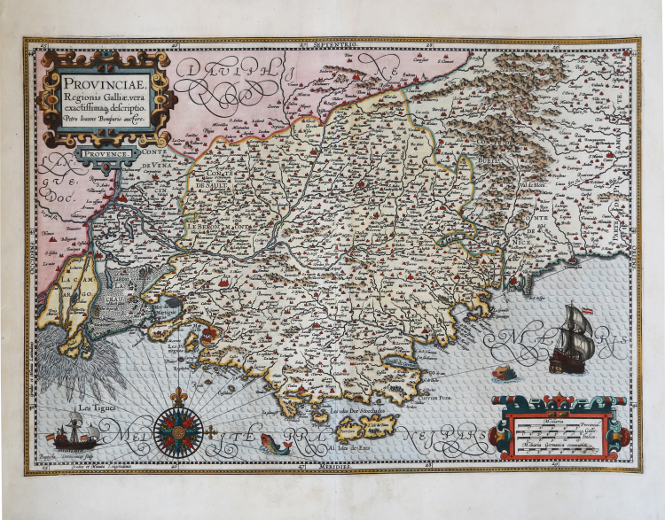
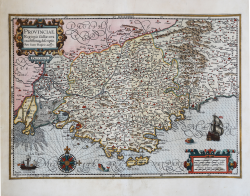
This superb, decorative map of Provence was based on Pierre-Jean de Bompar's map of 1591. It was engraved by the famous Dutch copperplate engraver Baptista van Doetecum who embellished it in his distinctive style with bold cartouches, an elaborate compass rose, sailing ships and sea monsters. The map covers the region from Avignon and the Rhone delta to Saluzzo and San Remo in Italy.
The Bompard map is the “first printed map of Provence, engraved by Giacomo Fornasieri for Pierre Jean de Bompar, royal judge of Grasse, in 1591. The map is made for the Duke of Savoy, Charles Emmanuel I (1562-1630), and was probably intended to have a military purpose and be used for the invasion of Provence. Indeed, this map is a valuable source of information because of the richness and novelty of the place names given: some villages and communes appear on a map for the first time. As Le Menn argues, however, its real author would be Jules-Raymond de Solier (ca. 1530-before 1595), a little-known Provençal astronomer and naturalist, the first writer on the region. The map signed by Bompar would therefore be older than 1591; it still shows, in fact, the medieval arm of Passon on the Rhone River, which was removed in 1587 to begin work on the new canal called Vidange and which does not appear on this map. The place of printing is not indicated in the work, which, on the basis of other engravings by Fornasieri, could be either Turin or Rome; the dedication to the Duke of Savoy leaves one leaning toward the Savoy capital, as Meurer has already dubiously indicated. However, we cannot rule out the possibility that the LES TIGNES that introduces the notice to Bompard's readers is the name of the small Savoyan village in the Alps, in which print may have been published in this case. Bompard's map was the basis for cartography of the region throughout the next century, replicated in all atlases since the plate inserted by Abraham Ortelius in the 1594 Theatrum Orbis Terrarum. The only known copy of the work is the one preserved at the Bibliothèque Municipale in Grenoble” (cfr. Cartografia e Topografia Italiana del XVI secolo, pp. 990-993, tav. 383).
Map taken from the Atlas sive cosmographicae meditationes de fabrica mundi.
In 1604, Jodocus Hondius (1563-1612) – probably trought Cornelis Claesz - bought the copperplates of Mercator’s Atlas sive cosmographicae meditationes de fabrica mundi at the auction of Gerard Jr.’s effects. He added about 40 maps, including new maps of the Continents and important regional maps of the Americas, before publishing a new edition of the Atlas, in 1606, in competition with Ortelius’ Theatrum Orbis Terrarum. As many of the maps were more up-to-date, the Mercator-Hondius Atlas effectively superseded Ortelius’ Theatrum. This atlas from 1606 include all 107 maps from the 1595 edition, as well as 37 new maps, skillfully engraved by Hondius, of various authors.
The second edition of the Mercator-Hondius atlas followed as soon as 1607/08. The first edition in another language, French, was put on the market in 1609. Apparently this one was regarded as the third edition, because in 1611 Editio Quarta appeared with a total of 150 maps. After the death of Jodocus Hondius in 1612 his widow and sons continued the publication of the Atlas. For instance Jodocus Junior (1594-1629) produced several new editions of the Editio Quarta between 1613 and 1619, each with the same 150 maps. Finally in 1619 the last edition of this atlas followed, to which six new maps were added. After 1620 the publication of the Atlas was continued by Henricus Hondius (ca. 1596/97-1651), the second son of Jodocus senior. Various editions appeared, in 1623, 1628 and 1630. Henricus Hondius was the first to make some real changes: in the 1628 edition he provided some Mercator maps with his own name. In 1630, when he was probably already cooperating with his brother-in- law Johannes Janssonius, Henricus added nine new maps.
Copperplate with fine later hand colour, very good condition.
|
Koeman I, 4700:1A. Van der Krogt (Vol. I) #4700:1A; cfr. S. Bifolco/F. Ronca, Cartografia e Topografia Italiana del XVI secolo (2018) pp. 990-993, tav. 383; Almagià (1953): pp. 222; Le Menn (1998): pp. 3-28; Meurer (1991): pp. 117.
|
Jodocus HONDIUS (Amsterdam 1563 - 1612)
|
Jodocus Hondius (1563-1612) was a foremost map engraver of his day; he worked for many Dutch publishers, and was employed by the English map and print-sellers, Sudbury and Humble, to engrave the maps for John Speed’s The Theatre of The Empire of Great Britaine, published in 1612. In 1604, Hondius bought the copperplates of Mercator’s Atlas at the auction of Gerard Jr.’s effects. He added another forty maps, including new maps of the Continents and important regional maps of the Americas, before publishing a new edition of the Atlas, in 1606, in competition with Ortelius’ Theatrum. As many of the maps were more up-to-date, the Mercator-Hondius Atlas effectively superseded Ortelius’ Theatrum. On his death in 1612 his widow, Coletta van den Keere continued the business; from 1619 onwards their son Henry (II) (1597-1651) took over. From 1633 publication was carried on in co-operation with Jan Jansson Jr., Henry’s brother-in-law.
|
|
Koeman I, 4700:1A. Van der Krogt (Vol. I) #4700:1A; cfr. S. Bifolco/F. Ronca, Cartografia e Topografia Italiana del XVI secolo (2018) pp. 990-993, tav. 383; Almagià (1953): pp. 222; Le Menn (1998): pp. 3-28; Meurer (1991): pp. 117.
|
Jodocus HONDIUS (Amsterdam 1563 - 1612)
|
Jodocus Hondius (1563-1612) was a foremost map engraver of his day; he worked for many Dutch publishers, and was employed by the English map and print-sellers, Sudbury and Humble, to engrave the maps for John Speed’s The Theatre of The Empire of Great Britaine, published in 1612. In 1604, Hondius bought the copperplates of Mercator’s Atlas at the auction of Gerard Jr.’s effects. He added another forty maps, including new maps of the Continents and important regional maps of the Americas, before publishing a new edition of the Atlas, in 1606, in competition with Ortelius’ Theatrum. As many of the maps were more up-to-date, the Mercator-Hondius Atlas effectively superseded Ortelius’ Theatrum. On his death in 1612 his widow, Coletta van den Keere continued the business; from 1619 onwards their son Henry (II) (1597-1651) took over. From 1633 publication was carried on in co-operation with Jan Jansson Jr., Henry’s brother-in-law.
|