| Reference: | s26246 |
| Author | Henry MICHELOT & Laurent BREMOND |
| Year: | 1727 ca. |
| Zone: | Marseille |
| Printed: | Marsiglia |
| Measures: | 255 x 185 mm |
| Reference: | s26246 |
| Author | Henry MICHELOT & Laurent BREMOND |
| Year: | 1727 ca. |
| Zone: | Marseille |
| Printed: | Marsiglia |
| Measures: | 255 x 185 mm |
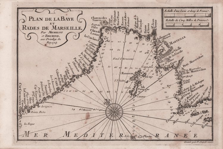
Nautical chart taken from the rare Recueil de Plusiereurs Plans des Ports et Rades de la Mer Mediterranée Dediée A Monseigneur le Grand Prieur de France, General des Galeres Levé et Dessigné sur les Lieux par les Srs. Michelot Hydrographe et Pilote Real des Galeres du Roy et Bremond Hydrographe du Roy et de la Ville, avec Pri.ge Du Roy (1727), nautical atlas of 37 plates, printed in Marseilles. The nautical plans are engraved by Pieter Starckman, one of the most active engravers of the time, collaborator of many cartographers and publishers. According to Shirley [see Maps in the Atlases of the British Library, p. 1234] the first edition of the work contains 21 plates, while the reprint, undated, contains 37 plates, some of which are dated 1730. The third and last edition contains 38 plates and is dated 1732.
Henry Michelot, after the success achieved with the publication of his nautical guide Le Portulan de Partie de la Mer Méditerranée, ou Le vray Guide des Pilotes Costiers (1703), joined Laurent Bremond. In the early 18th century Henry Michelot and Laurens Bremond published two important nautical atlases of the Mediterranean and nautical plans widely used by coastal mariners. The charts are interesting and important for the reliability derived from the experience of Michelot who, unlike later "geographers of the Dépôt des cartes et plans de la Marine" such as Jacques-Nicolas Bellin, had long experience at sea. The first atlas produced contains 16 maps, on a small scale, of the Mediterranean and the Atlantic coast near the Strait of Gibraltar, supplemented by one or more coastal profiles. The dates of the charts are between 1715 and 1726; at this time Michelot signed himself as Hydrographe et Pilote Real des Galères du Roy (hydrographer and pilot of the royal galley for the kings' galley corps). Little is known about the co-creator of the work Laurent Bremond. In the nautical collection his name always succeeds that of Michelot, and he is qualified as Hydrographe du Roy et de la Ville (hydrographer of the king and the city). Bremond would seem to have been the publisher and seller of the nautical collection, the commercial force of the company; owner of a sort of store near the port. All charts are clearly marked: Ce vendent a Marseille chez Laurens Bremond sur le Port au coin de Reboul (sold in Marseille by Laurens Bremond in the port at the corner of Reboul).
Copper engraving, in excellent condition.
Literature
S. Bifolco, Mare Nostrum (2019), pp. 270-271, tav. 122; Palau, 168325. Tooley, 438.80.
Henry MICHELOT & Laurent BREMOND
|
Henry Michelot fu un navigatore, cartografo e idrografo francese della fine del XVII e l’inizio del secolo successivo. Le sue opere sul Mediterraneo furono realizzate durante il periodo più florido della cartografica francese, e vennero utilizzate dai naviganti per oltre un secolo. Gli viene attribuita la paternità – esclusiva o associata - di numerose influenti opere cartografiche dedicate al Mediterraneo. Michelot, come riportato nel cartiglio di diverse sue carte nautiche, era idrografo e pilota per le galere reali di Francia e fu strettamente legato alla città di Marsiglia, che era il porto principale della marina francese nel Mediterraneo tra il 1680 e il 1740. La sua lunga esperienza per mare e la conoscenza diretta delle aree rappresentate, sono alla base del successo delle sue carte. Le sue opere sono caratterizzate da elaborati cartigli e da un’iconografia che rimanda a eventi contemporanei, come le guerre per mare, le raffigurazioni degli schiavi musulmani catturati, oppure la peste di Marsiglia del 1720. Le sue prime carte nautiche risalgono all’ultimo decennio del ’600. La città di Marsiglia, a quel tempo, era la sede del Corp des Galeres di Luigi XIV, formata da circa 40 galeee a vela, che era una flotta separata dalla Marina francese, la cui sede era Tolone.
|