| Reference: | s34966 |
| Author | Henrick SCHERER |
| Year: | 1702 ca. |
| Zone: | Europe |
| Printed: | Munich |
| Measures: | 360 x 235 mm |
| Reference: | s34966 |
| Author | Henrick SCHERER |
| Year: | 1702 ca. |
| Zone: | Europe |
| Printed: | Munich |
| Measures: | 360 x 235 mm |
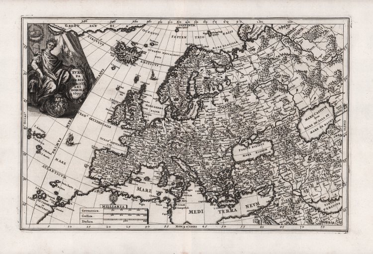
Nice map of Europe, by Henrick Scherer, bated 1699 but published in 1703 for his Atlas Novus exhibens orbem terraguem per naturae opera, historiae navae acveterus monumenta, artistique geographicae leges et praecepta...published in eight volumes from 1702-1710 in Munich. Scherer, a devout Jesuit, produced this geographical compendium to depict the Catholic hierarchy and the spread of Jesuit missions throughout the world.
This map shows the Christian dominated lands in Europe and is densely engraved with towns, rivers, and depictions of forests and mountains.
The map extends west to show Iceland and the eastern coast of Greenland. The decorative cartouche featuring the female representation of Europe sitting upon a globe.
Copper engraving, in very good condition.
|
Shirley (BL Atlases) T.SHER-1a #60.
|
Henrick SCHERER (Dilingen 1628 - Monaco 1704)
|
Heinrich Scherer was a devout Jesuit, and professor of mathematics at Munich. His 'Atlas Novus' contained maps of all other parts which showed the spread of Catholicism and Jesuit missions.
|
|
Shirley (BL Atlases) T.SHER-1a #60.
|
Henrick SCHERER (Dilingen 1628 - Monaco 1704)
|
Heinrich Scherer was a devout Jesuit, and professor of mathematics at Munich. His 'Atlas Novus' contained maps of all other parts which showed the spread of Catholicism and Jesuit missions.
|