
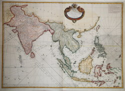
| Reference: | s19810 |
| Author | Rigobert BONNE |
| Year: | 1771 |
| Zone: | East Indies |
| Printed: | Paris |
| Measures: | 805 x 575 mm |
| Reference: | s19810 |
| Author | Rigobert BONNE |
| Year: | 1771 |
| Zone: | East Indies |
| Printed: | Paris |
| Measures: | 805 x 575 mm |
Map taken from the "Atlas Moderne ou Collection De Cartes Sur toutes les parties du Globe Terrestre par Plusieurs Auteurs" edited by Giovanni Antonio Rizzi Zannoni and published in Paris by Jean Lattré for the first time in 1762, and successively printed with the addition of numerous maps of other cartographers, until the end of the century.
Rigobert Bonne (1727-1795) was one of the most important cartographers of the late 18th century. In 1773 he succeeded Jacques Bellin as Royal Cartographer to France in the office of the Hydrographer at the Depôt de la Marine. Working in his official capacity Bonne compiled some of the most detailed and accurate maps of the period. Bonne's work represents an important step in the evolution of the cartographic ideology away from the decorative work of the 17th and early 18th century towards a more detail oriented and practical aesthetic. With regard to the rendering of terrain Bonne maps bear many stylistic similarities to those of his predecessor, Bellin. However, Bonne maps generally abandon such common 18th century decorative features such as hand coloring, elaborate decorative cartouches, and compass roses. While mostly focusing on coastal regions, the work of Bonne is highly regarded for its detail, historical importance, and overall aesthetic appeal.
The Atlas Encyclopédique, that Bonne completed with the help of Nicholas Desmarest, constitutes his most famous work.
Copper engraving, with fine later hand colour, in good condition.
|
C. Quirino, Philippine Cartography, p. 149
|
Rigobert BONNE (1727 - 1795 ca.)
|
Rigobert Bonne was born in 1727 in Raucourt, in the Lorraine region of northeastern France. He was not only a cartographer but also a hydrographer who produced both land and nautical maps; he spent much of his career working in the French Hydrographic Office or Dépôt des cartes et plans de la Marine. As Royal Hydrographer, Bonne's main interest was the production of nautical maps, but he also gave to print a considerable number of other works, including maps by other cartographers who were his collaborators. He first came to prominence producing a series of plates for the Atlas Moderne ou Collection De Cartes Sur toutes les parties du Globe Terrestre par Plusieurs Auteurs, edited by Giovanni Antonio Rizzi Zannoni and first published in Paris by Jean Lattré in 1762, and subsequently reprinted-with the addition of numerous plates by other cartographers-until the end of the century. But he is probably best known for later publications, including the Atlas Encyclopedique-in collaboration with Nicholas Desmarest (1725-1805)-as well as for the maps he made for Guillaume Raynal's Atlas de Toutes Les Parties Connues du Globe Terrestre (1780). His maps were often commissioned more for educational and informational purposes than for practical use. In 1773, Bonne's talent was rewarded with the title of "Hydrographe du Roy," succeeding Jacques-Nicolas Bellin. From him took its name the pseudoconic projection, adopted, among other things, for the general map of France.
|
|
C. Quirino, Philippine Cartography, p. 149
|
Rigobert BONNE (1727 - 1795 ca.)
|
Rigobert Bonne was born in 1727 in Raucourt, in the Lorraine region of northeastern France. He was not only a cartographer but also a hydrographer who produced both land and nautical maps; he spent much of his career working in the French Hydrographic Office or Dépôt des cartes et plans de la Marine. As Royal Hydrographer, Bonne's main interest was the production of nautical maps, but he also gave to print a considerable number of other works, including maps by other cartographers who were his collaborators. He first came to prominence producing a series of plates for the Atlas Moderne ou Collection De Cartes Sur toutes les parties du Globe Terrestre par Plusieurs Auteurs, edited by Giovanni Antonio Rizzi Zannoni and first published in Paris by Jean Lattré in 1762, and subsequently reprinted-with the addition of numerous plates by other cartographers-until the end of the century. But he is probably best known for later publications, including the Atlas Encyclopedique-in collaboration with Nicholas Desmarest (1725-1805)-as well as for the maps he made for Guillaume Raynal's Atlas de Toutes Les Parties Connues du Globe Terrestre (1780). His maps were often commissioned more for educational and informational purposes than for practical use. In 1773, Bonne's talent was rewarded with the title of "Hydrographe du Roy," succeeding Jacques-Nicolas Bellin. From him took its name the pseudoconic projection, adopted, among other things, for the general map of France.
|