
| Reference: | S43057 |
| Author | Isaak TIRION |
| Year: | 1744 |
| Zone: | Philippines |
| Printed: | Amsterdam |
| Measures: | 345 x 300 mm |
| Reference: | S43057 |
| Author | Isaak TIRION |
| Year: | 1744 |
| Zone: | Philippines |
| Printed: | Amsterdam |
| Measures: | 345 x 300 mm |
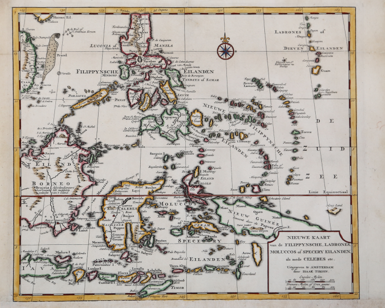
Beautifully engraved map of South East Asia, the Philippines and the Indonesian Spice Islands. Published in Amsterdam around the year 1744 by Isaak Tirion.
Originates from Nieuwe Hand-Atlas, bestaande in eene Verzameling van eenige naauwkeurige Landkaarten.
The Amsterdam based publisher Isaak Tirion (1705-1769) is known to have produced books, charts and maps for the Dutch mercantile elite. Tirion was primarily a cartographic publisher, who issued several lavish atlases as well as smaller geographical guides (literally 'Hand-Atlas'), from which this attractive map is derived. During his prolific career, Tirion was associated with the Dutch East India Company; in 1757 Willem Udemans, a shipwright and director of the VOC shipyard at Middelburg commissioned Tirion to print a treatise on naval architecture. He also published a Dutch language edition of Commodore Anson's circumnavigation in 1749, a work remarkable for the quality of its maps and charts.
Copperplate with fine later hand colour, added margina t the bottom, otherwise good condition.
Bibliografia
Quirino, pp.137-139.
Isaak TIRION (1705 ca. - 1765)
|
A successful publisher in Amsterdam, who produced extensive volumes of Dutch town plans as well as a number of atlases with maps usually based on those of G. Delisle.
|
Isaak TIRION (1705 ca. - 1765)
|
A successful publisher in Amsterdam, who produced extensive volumes of Dutch town plans as well as a number of atlases with maps usually based on those of G. Delisle.
|