| Reference: | S50367 |
| Author | Jodocus HONDIUS |
| Year: | 1606 ca. |
| Zone: | Cyprus |
| Printed: | Amsterdam |
| Measures: | 490 x 355 mm |
| Reference: | S50367 |
| Author | Jodocus HONDIUS |
| Year: | 1606 ca. |
| Zone: | Cyprus |
| Printed: | Amsterdam |
| Measures: | 490 x 355 mm |
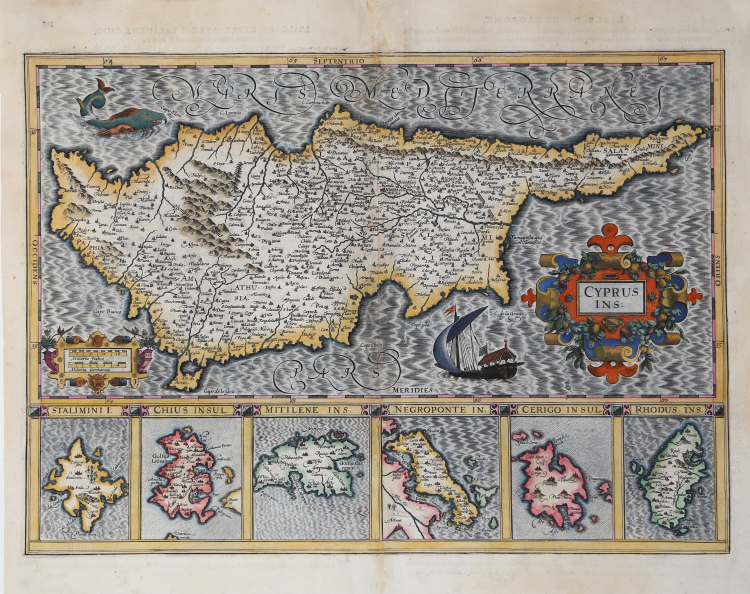
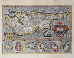
This map shows Cyprus, plus insets of six islands: Stalimini, Chius, Mitelene, Negroponte, Cerigo, and Rhodus. This map is from one of the great Hondius/Mercator atlases of the early 17th century. Jodocus Hondius (1563-1612) bought Mercator's map plates and added many of his own and also improved on Mercator's and Ortelius's maps.
After his death, he was succeeded in the business by his sons and they issued many editions of their justly celebrated atlases between 1605 and 1641 with texts in several languages. This is from a latin edition.
Copper engraving, magnificent contemporary colour, repairs at the middle fold, otherwise in good condition.
|
A. & J. Stylianou, "The History of the Cartography of Cyprus", pp. 82-83, 98; L. Navari, "Maps of Cyprus", p. 139, 51; Zacharakis C. G. "A Catalogue of Printed Maps of Greece 1477 - 1800" (2009), n. 2211; Sweet Land of Cyprus, n. 45
|
Jodocus HONDIUS (Amsterdam 1563 - 1612)
|
Jodocus Hondius (1563-1612) was a foremost map engraver of his day; he worked for many Dutch publishers, and was employed by the English map and print-sellers, Sudbury and Humble, to engrave the maps for John Speed’s The Theatre of The Empire of Great Britaine, published in 1612. In 1604, Hondius bought the copperplates of Mercator’s Atlas at the auction of Gerard Jr.’s effects. He added another forty maps, including new maps of the Continents and important regional maps of the Americas, before publishing a new edition of the Atlas, in 1606, in competition with Ortelius’ Theatrum. As many of the maps were more up-to-date, the Mercator-Hondius Atlas effectively superseded Ortelius’ Theatrum. On his death in 1612 his widow, Coletta van den Keere continued the business; from 1619 onwards their son Henry (II) (1597-1651) took over. From 1633 publication was carried on in co-operation with Jan Jansson Jr., Henry’s brother-in-law.
|
|
A. & J. Stylianou, "The History of the Cartography of Cyprus", pp. 82-83, 98; L. Navari, "Maps of Cyprus", p. 139, 51; Zacharakis C. G. "A Catalogue of Printed Maps of Greece 1477 - 1800" (2009), n. 2211; Sweet Land of Cyprus, n. 45
|
Jodocus HONDIUS (Amsterdam 1563 - 1612)
|
Jodocus Hondius (1563-1612) was a foremost map engraver of his day; he worked for many Dutch publishers, and was employed by the English map and print-sellers, Sudbury and Humble, to engrave the maps for John Speed’s The Theatre of The Empire of Great Britaine, published in 1612. In 1604, Hondius bought the copperplates of Mercator’s Atlas at the auction of Gerard Jr.’s effects. He added another forty maps, including new maps of the Continents and important regional maps of the Americas, before publishing a new edition of the Atlas, in 1606, in competition with Ortelius’ Theatrum. As many of the maps were more up-to-date, the Mercator-Hondius Atlas effectively superseded Ortelius’ Theatrum. On his death in 1612 his widow, Coletta van den Keere continued the business; from 1619 onwards their son Henry (II) (1597-1651) took over. From 1633 publication was carried on in co-operation with Jan Jansson Jr., Henry’s brother-in-law.
|