
| Reference: | S46102 |
| Author | Abraham ORTELIUS |
| Year: | 1584 ca. |
| Zone: | Crete, Sardinia, Corsica |
| Printed: | Antwerpen |
| Measures: | 485 x 345 mm |
| Reference: | S46102 |
| Author | Abraham ORTELIUS |
| Year: | 1584 ca. |
| Zone: | Crete, Sardinia, Corsica |
| Printed: | Antwerpen |
| Measures: | 485 x 345 mm |
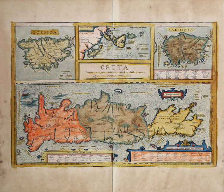
Splendid historical map of the ancient Crete, published in Abraham Ortelius' Parergon.
This plate depicts, oriented differently to the east or north, Crete and other Ionian islands (Corfu, Ithaca, Zakynthos, Lefkada), Sardinia and Corsica, each with graduated margin, longitude and latitude, placed in boxes in which a list of places of unknown location is also given. The back of the sheet gives descriptions of the islands depicted.
Example from the rare Italian edition of Theatrum Orbis Terrarum printed in Antwerp by Jean Baptiste Vrients in 1608 and then in 1612. A second state of the plate with some place names added.
Plate size: 342 x 491 mm. Four maps on one plate.
For the Crete map: CRETA | Iovis magni, medio iacet insula ponto. | "Ex conatibus geographicis Abrahami Ortelij". [The isle of Creta, belonging to great Iupiter, which lies in the middle of the sea, from the geographical efforts of Abraham Ortelius], Ortelius mentions the contemporary source Francesco Superanti (Soranzo), and as classical sources Strabo, Athenæus, Diodorus Siculus and Heraclides.
For the Corsica map Ortelius mentions as his classical sources Athenæus, Eustathius, Martianus Capella, Diodorus Siculus, Strabo, Seneca and Livius.
For the Ionian Islands, title: INSVLAE MA:|RI IONII. Middle top: ITHACA INS. | "in qua Neritus mons. | Arethusa fons, et | Coracis petra". [The isle of Ithaca with mount Neritus, the spring of Arethusa and the rocks of Coracis]. Middle top: ZACYNTHVS | INS. "in qua | Elatus mons". [The isle of Zacynthus with mount Elatus]. Ortelius mentions as his classical sources Strabo, Palenses, Athenæus, Livius and Plinius.
For the Sardinia Ortelius mentions as his classical sources Eustathius, Pausanias, Polybius, Strabo, Prudentius, Salvanius, Sidonius, Pomponius, Dioscorides, Plinius and Claudiamus
The Parergon is the first historical atlas ever published. It was initially conceived by Ortelius as an appendix to his Theatrum Orbis Terrarum but given the considerable success of these historical maps it later became an independent work and remained the main source of all similar works throughout the seventeenth century.
Koeman wrote: “This atlas of ancient geography must be regarded as a personal work of Ortelius. For this work he did not, as in the Theatrum, copy other people's maps but drew the originals himself... He took many places and regions from the lands of classical civilization to illustrate and clarify their history, a subject very close to his heart... The maps and plates of the Parergon have to be evaluated as the most outstanding engravings depicting the wide-spread interest in classical geography in the 16th century."
The Theatrum Orbis Terrarum, which is considered the first true modern "Atlas". The work was published in 7 languages and 36 editions, for which - in 1570 - Ortelius obtained the privilege, a kind of copyright that prevented other cartographers from publishing his works. The Theatrum represented the most advanced work of cartographic description. Ortelius collected in it the geographical and cartographic knowledge of his time, proposing in 147 spectacular engraved plates the most faithful image of the world then known and, in some extraordinary "historical maps", regions and routes taken from literature, mythology, tradition.
Example with magnificent contemporary coloring, paper slightly browned, otherwise in excellent condition.
Bibliografia
Cfr. L. Bagrow, A. Ortelli Catalogus Cartographorum; cfr. C. Koeman, Atlantes Neerlandici; Peter H. Meurer, Fontes Cartographici Orteliani 7p/a-d; M. Van den Broecke, Ortelius Atlas Maps, n. 217; Van der Krogt, Koeman’s Atantes Neerlandici: 7900H:31.
Abraham ORTELIUS (1528 - 1598)
|
Abraham Ortel, better known as Ortelius, was born in Antwerp and after studying Greek, Latin and mathematics set up his business there with his sister, as a book dealer and 'painter of maps'. Travelling widely, especially to the great book fairs, his business prospered and he established contacts with many sultured men in many lands. On one such visit to England, possibly seeking temporary refuge from religious persecution, he met William Camden whom he is said to have encouraged in the production of the Britannia.
A turning-point in his career was reached in 1564 with the publication of a World Map in eight sheets of which only one copy is known: other individual maps followed and then - at the suggestion of a friend - he gathered together a collection of maps from contacts among European cartographers and had them engraved in uniform size and issued in 1570 as the Theatrum Orbis Terrarum (Atlas of the Whole World). Although Lafreri and others in Italy had published collections of 'modern' maps in book form in earlier years, the Theatrum was the first uniformly sized, systematic collection of maps and hence can be called the first atlas, although that term itself was not used until twenty years later by Mercator.
The Theatrum, with most of its maps elegantly engraved by Frans Hogenberg, was an instant success and appeared in numerous editions in different languages including addenda issued from time to time incorporating the latest contemporary knowledge and discoveries. The final edition appeared in 1612. Unlike many of his contemporaries Ortelius noted his sources of information and in the first edition acknowledgement was made to eighty-seven different cartographers.
Apart from the modern maps in his major atlas, Ortelius himself compiled a series of historical maps known as the Parergon Theatri which appeared from 1579 onwards, sometimes as a separate publication and sometimes incorporated in the Theatrum.
1570 Theatrum Orbis Terrarum 1570-1612 Between these years the Theatrum was re-issued in 42 editions with 5 supplements with text in Latin, Dutch, German, French, Spanish, Italian and English. The English edition was published in 1606 by John Norton, the maps being printed in Antwerp and the text added in London. Three years later Ortelius died in 1598, his heirs transferred publication rights to Jan Baptiste Vrients who produced the posthumous editions until he died in 1612
1577-85 Spiegel der Werelt (8vo) Maps from the Theatrum, reduced in size, engraved by Philip Galle: text by Pieter Heyns. 6 editions with Dutch, French and Latin text. 1588-i 603 Epitome theatri orbis terrarum (12mo/8v0) 11 further editions of the smaller maps with an increasing number of maps with text also in Italian and English (1603). i6oi-i 2 7 further editions with improved engravings by Arsenius Brothers: text by Michel Coignet in Latin, French, German, Italian and English (1603). 1598-1724 Theatro del Mondo (4t0/12mo/24mo) 8 editions with Italian text; plates engraved in Italy.
1579-1606 Parergon Theatri The number of maps included in the Parergon increased from 4 in 1579 to 43 in 1606 with text in Latin, French, Italian, German and English (1606) 1624 Re-issued in Antwerp as a separate publication by Balthasar Moretus. This edition included a reproduction of the Peutinger table.
|