
| Reference: | CO-062 |
| Author | Gilles Robert de VAUGONDY |
| Year: | 1750 |
| Zone: | Central Italy |
| Printed: | Paris |
| Measures: | 630 x 495 mm |
| Reference: | CO-062 |
| Author | Gilles Robert de VAUGONDY |
| Year: | 1750 |
| Zone: | Central Italy |
| Printed: | Paris |
| Measures: | 630 x 495 mm |
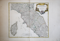
This is an attractive 1750 map by Robert de Vaugondy depicting central Italy and regions of Tuscany, the Papal States and the Island of Corsica. It covers from Ferrara and Parma south to Terracina. Several important towns, cities, roads, rivers, lakes and other topographical features are noted, with elevation beautifully rendered.
This map shows the Italian peninsula prior to its struggle for national solidarity which would emerge as a movement about 50 years later in the early 19th century. The peninsula was divided into numerous independent states, duchies, republics, kingdoms and, of course, the Papal States (States of the Church).
A beautifully illustrated title cartouche adorns the top right quadrant of the map. This map was drawn by Robert de Vaugondy in 1750 and published in the 1757 issue of his Atlas Universal. The Atlas Universal was one of the first atlases based upon actual surveys. Therefore, this map is highly accurate (for the period) and has most contemporary town names correct.
|
F. Ronca e A. Sorbini (a cura di) "Le antiche terre del Ducato di Spoleto", p. 178, n. 75.
|
Gilles Robert de VAUGONDY (1688 - 1766)
|
Didier Robert de Vaugondy (1723-1786) was appointed Geographer to Louis XV in 1760. At the same time, de Vaugondy served as Geographer to the Duke of Lorraine and Bar, father-in-law to Louis XV and former King of Poland.
His major contributions to French cartography are the Atlas Universel, 1750-57, The Nouvelle Atlas Portatif (1784) and a very popular map of North America published in 1761. He was son of Gilles Robert de Vaugondy who succeeded Pierre Sanson as the King's Geographer.
|
|
F. Ronca e A. Sorbini (a cura di) "Le antiche terre del Ducato di Spoleto", p. 178, n. 75.
|
Gilles Robert de VAUGONDY (1688 - 1766)
|
Didier Robert de Vaugondy (1723-1786) was appointed Geographer to Louis XV in 1760. At the same time, de Vaugondy served as Geographer to the Duke of Lorraine and Bar, father-in-law to Louis XV and former King of Poland.
His major contributions to French cartography are the Atlas Universel, 1750-57, The Nouvelle Atlas Portatif (1784) and a very popular map of North America published in 1761. He was son of Gilles Robert de Vaugondy who succeeded Pierre Sanson as the King's Geographer.
|