| Reference: | CO-603 |
| Author | Tobias LOBECK & Tobias Conrad LOTTER |
| Year: | 1762 |
| Zone: | Central Italy |
| Printed: | Ausburg |
| Measures: | 135 x 110 mm |
| Reference: | CO-603 |
| Author | Tobias LOBECK & Tobias Conrad LOTTER |
| Year: | 1762 |
| Zone: | Central Italy |
| Printed: | Ausburg |
| Measures: | 135 x 110 mm |
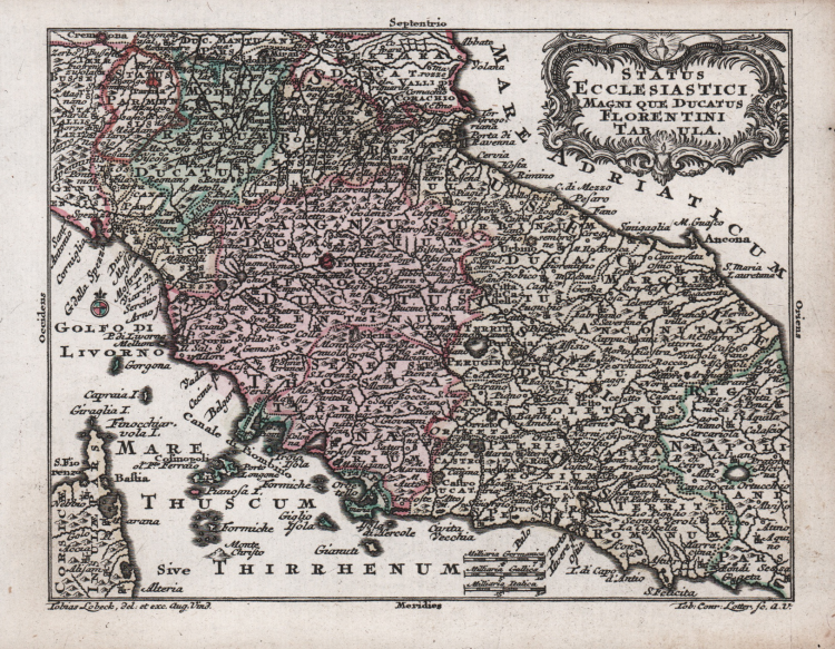
Piccola carta geografica dello Stato della Chiesa con la Toscana, tratta dall'opera Atlas geographicus portatilis XXIX mappis orbis habitabilis regna exhibens. Caelo accurate expressit Tobias Conradus Lotterus, deliniavit et excudit Tobias Lobeck. Chalcograph Augustan. Vendit in ejus aedibus in suburb. Jacobae in reg. Paradisi. Augustae Vindelicorum, 1762.
“Senza graduazione ai margini. Orientata su quattro lati e con la rosa dei venti. Le scale sono in miglia tedesche, francesi e italiane. Semplice è il cartiglio, che con artistici risvolti incornicia il titolo. La tavola è anche nella raccolta di F. R. Cassano che ne individua l'Autore in T. C. Lotter, già menzionato quale genero di Matteo Seutter (Lobeck ne sarebbe pertanto solo il disegnatore). È d'uopo il richiamo alla carta del Sanson, pubblicata oltre un secolo prima (1648) e dalla quale diverge appena per i confini e pochi altri elementi, nonché a quella del Seutter di cui può dirsi semplificazione. Insignificante è la raffigurazione dell'orografia, affidata al disegno di pochi e sparsi monticelli illuminati da sinistra” (cfr. "Le antiche terre del Ducato di Spoleto", p. 80).
Acquaforte, coloritura coeva, in ottimo stato di conservazione.
|
F. Ronca e A. Sorbini (a cura di) "Le antiche terre del Ducato di Spoleto", p. 186, 79.
|
Tobias LOBECK & Tobias Conrad LOTTER
|
German publisher and engraver who married the daughter of the elder Matthaus Seutter. He engraved many of Seutter’s maps and eventually succeeded to the business in 1756, becoming one of the better known cartographers in the eighteenth-century German School. After his death the business was carried on by his son, M. A. Lotter
c.1744 Atlas Minor
1760 -62 Atlas Geographicus portabilis
c.1770 Atlas Novus
1776 A map of the most inhabited part of New England
1778 Atlas Geographique
1778 (M.A. Lotter) World Map showing Cook’s voyages
|
|
F. Ronca e A. Sorbini (a cura di) "Le antiche terre del Ducato di Spoleto", p. 186, 79.
|
Tobias LOBECK & Tobias Conrad LOTTER
|
German publisher and engraver who married the daughter of the elder Matthaus Seutter. He engraved many of Seutter’s maps and eventually succeeded to the business in 1756, becoming one of the better known cartographers in the eighteenth-century German School. After his death the business was carried on by his son, M. A. Lotter
c.1744 Atlas Minor
1760 -62 Atlas Geographicus portabilis
c.1770 Atlas Novus
1776 A map of the most inhabited part of New England
1778 Atlas Geographique
1778 (M.A. Lotter) World Map showing Cook’s voyages
|