| Reference: | MS4140 |
| Author | Georg Louis le ROUGE |
| Year: | 1756 |
| Zone: | Jamaica, Bermuda |
| Printed: | Paris |
| Measures: | 285 x 217 mm |
| Reference: | MS4140 |
| Author | Georg Louis le ROUGE |
| Year: | 1756 |
| Zone: | Jamaica, Bermuda |
| Printed: | Paris |
| Measures: | 285 x 217 mm |
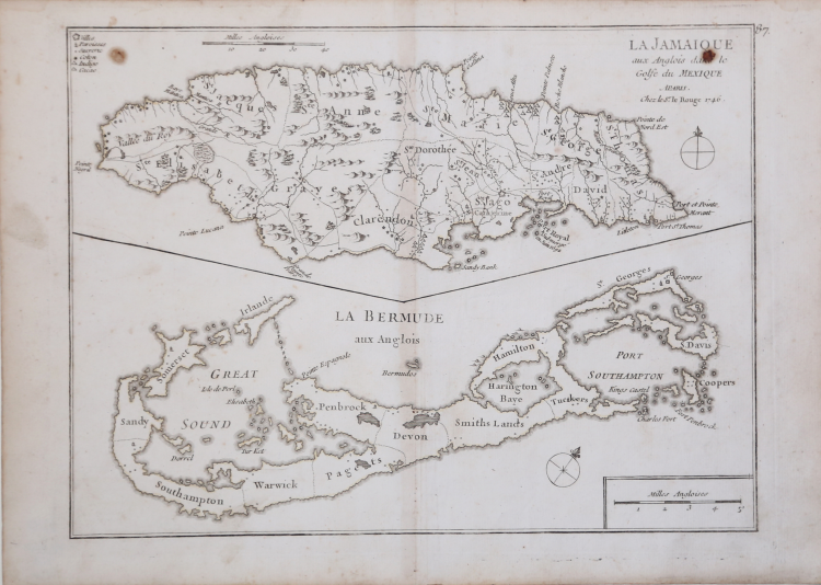
The sheet contains two maps, Jamaica above Bermuda. Jamaica is engraved to show the plantations, denoting those growing sugar, cotton, cacao, and indigo.
The map of Bermuda includes an interesting cartographic error resulting from the copying John Speed's map of 1627.
In that map, Bermuda was superimposed over a map of the coastline of New England and Virginia to show the relative position of Bermuda. Here, the coastlines of North America are gone, but the small depiction of an additional Bermuda remains, which appears on this map as a small offshore island named Bermudos.
Map taken from the "Introduction a la Geographie" published from 1747 and 1756, printed in "Paris, chez l'Auteur, Prault le fils, la Veuve Robinot, 1756".
The work, which the author defines as "Atlas Nouveau Portatif à l'Usage des Militaires et du Voyageur", contains 86 maps.
Copperplate with original outline colour, very good conditions.
Georg Louis le ROUGE (1721-1790 circa)
|
A military engineer by profession, Le Rouge took up cartography and over a long period from about 1740 to 1780 produced many attractive works covering a wide range of subjects, including plans of fortifications, military campaigns, town plans as well as the more usual atlases and sea charts.
1741-62 Atlas General
1742 Recueil des cartes Nouvelles (including a reissue on reduced scale of Henry Popple’s map of America of 1733)
1748 Atlas Nouveau Portatif (4to)
1756,c.1767 re-issued
1755 Recueil des Plans de l’ Amerique(8vo)
1756 Introduction de Geographie
1758 Atlas Prussien
1759 recueil des villes ,portes d’ Angleterre (8vo)
1760 Topographie des Chemins d’ Angleterre (8vo)
1778 Atlas Ameriquain Septentrional
|