| Reference: | s40990 |
| Author | Giovanni Antonio MAGINI |
| Year: | 1607 ca. |
| Zone: | Latium |
| Printed: | Bologna |
| Measures: | 470 x 365 mm |
| Reference: | s40990 |
| Author | Giovanni Antonio MAGINI |
| Year: | 1607 ca. |
| Zone: | Latium |
| Printed: | Bologna |
| Measures: | 470 x 365 mm |
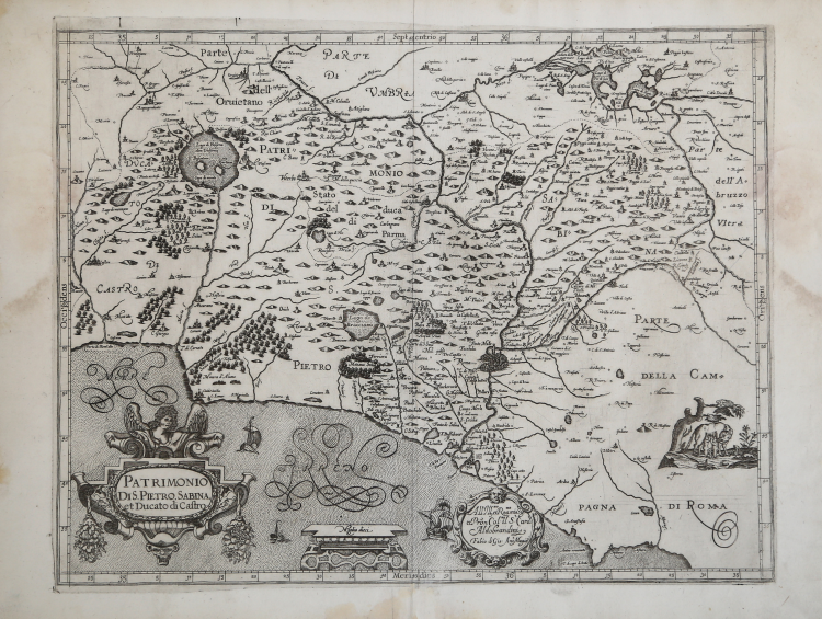
Map taken from L'Italia edited by Fabio Magini, published in Bologna in 1620, three years after the untimely death of his father.
Composed of a short descriptive text of only 24 pages, the work is accompanied by 61 maps of the peninsula, and is the first example of an Italian atlas. The work is entirely by the hand of Giovanni Antonio Magini, who began the realization of the maps in 1594 or so; the first dated map (1595) the map of the territory of Bologna. All the maps were printed before 1620, in their provisional drafts, later corrected and updated for the final edition. For the realization of the plates Magini used two of the most famous engravers of the time: the Belgian Arnoldo Arnoldi and the English Benjamin Wright.
Copperplate, in good condition.
Magini's maps of Latium have a complex background. He is the first to divide this region into two parts, using the courses of the Aniene and Tiber rivers as borders. This particular map shows the territories situated to the north of these two rivers and is the outcome of the study of previous works.The coastline up to the town of Civitavecchia is after Buonsignori while the northwestern part of the region was inspired by Bellarmato.
The area around the lake of Bolsena is taken from Danti and, finally, in the rendering of the countryside in the immediate whereabouts of the northern suburbs of Rome the influence of Eufrosino della Volpaia's 1547 map can be seen. Engraved by Benjamin Wright after 1606.
In basso, nel cartiglio a sinistra, il titolo PATRIMONIO DI S.PIETRO, SABINA et Ducato di Castro. Al centro la scala grafica Miglia dieci (10 miglia pari a mm 50), nel cartiglio a destra la dedica All’ Ill.mo et Rev.mo mio Sig.r et P[at]ron[us] Col.mo il S.r Card:e Aldobrandini. Fabio di Gio. Ant.o Magini. Nel lato destro una vignetta raffigurante la lupa con Romolo e Remo. Orientazione nei quattro lati al centro con il nome dei punti cardinali Septentrio, Meridies, Oriens, Occidens, il nord in alto.
Graduazione ai margini di 1’ in 1’ da 41° 30’ a 42° 29’ di latitudine, e da 34° 51’ 10’’ a 36° 38’ 10’’ di longitudine.
Incisa da Benjamin Wright dopo il 1606. In ottimo stato di conservazione.
Bibliografia
Almagià (1960): pp. 24-25, tav. XLIII; Frutaz (1972): pp. 41-42, XXII, tav. 53.
Giovanni Antonio MAGINI (1555 - 1617)
|
Giovanni Antonio Magini was born in Padua in 1555, dedicating himself to the study of astronomy from an early age. In 1588 the Senate of Bologna appointed him Lecturer of Astronomy at the local University, choosing him instead of Galileo Galilei. His friendship with the Duke of Mantua, Vincenzo Gonzaga, helped Magini in his quest to obtain cartographical material for map-making from the various sovereigns ruling the different Italian states at that time. Because of Magini's early death in 1617, this effort was made famous by his son Fabio when he published the atlas "L'Italia" in Bologna in 1620. This is the first example of an Italian atlas and is made up of 24 pages of descriptive text and 61 maps of the Italian peninsula. Although this work was published posthumously, it can be entirely ascribed to Magini. He began drawing this maps around 1594, with the one depicting Bologna and its surrounding territories being the first. They were all printed before 1620 in draft editions which were then revised and updated for the final version. These draft proofs are extremely rare, although sometimes available for sale, and exhibit substantial differences in respect to the maps finally included in the atlas. Two of the most famous engravers of the time, Arnoldo Arnoldi and the englishman Benjamin Wright, were entrusted by Magini to engrave the plates. As we shall see in the presentation of the separate maps, they derive from different sources, both known and unknown, and therefore represent the result of an original work of critical analysis and compilation. This atlas had an important influence on the cartography of the italian peninsula for the following two centuries, beginning from Ortelius and going on to the principal dutch cartographers and editors.
|