| Reference: | CO-170 |
| Author | Innocenzo MATTEI |
| Year: | 1666 |
| Zone: | Lazio |
| Printed: | Rome |
| Measures: | 520 x 400 mm |
| Reference: | CO-170 |
| Author | Innocenzo MATTEI |
| Year: | 1666 |
| Zone: | Lazio |
| Printed: | Rome |
| Measures: | 520 x 400 mm |
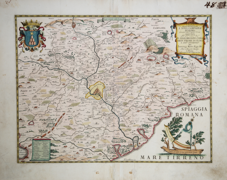
Map taken from Mercurio geografico overo Guida Geografica in tutte le parti del Mondo conforme le Tavole Geografiche del Sansone Baudran de Cantelli Data in luce con direttione, e cura di Gio. Giacomo de Rossi nella sua stamperia collection of maps published in Rome between 1660 and 1730 by the typography De Rossi - the date of the maps goes from 1669 to 1715 - whose first edition is due to Giovanni Giacomo de Rossi. Over the years the atlas was enriched by an increasing number of maps in subsequent editions edited first by Domenico de Rossi and then by his son Filippo.
The Mercurio Geografico is a collection that brings together works by cartographers such as Michele Antonio Baudrand, Nicolas Sanson, Augustin Lubin, Filippo Titi, Giacomo Ameti, Giovanni Antonio Magini and Innocenzo Mattei, and which includes as its main "corpus" the great production of the geographer Giacomo Cantelli da Vignola. The maps are finely copied and engraved by the major engravers of the time including Falda, Widman, Barbey, Widman, Lhuillier, Donia, Mariotti.
Striking and highly detailed map of the region around Rome, engraved by Giorgio Widman and published in Rome by Giacomo Rossi, the most important map maker working in Rome during the second half of the 17th Century.
Innocenzo Mattaei was appointed as the official cartographer to the Papal States by Pope Clemente X. The present map was originally prepared by Mattei in 1666 and later engraved by Widman and issued by the Rossi family in their Mercurio Geografico. It represents perhaps the most accurate and detailed map of the region to appear in a commercial atlas of the period and reflects the skill of the engraver and the high quality of engraving work being done in Rome in the second half of the 17th Century, a period during which a new generation of Italian map makers produced a number of decorative and important separately issued maps and atlases at a scale not scene since Lafreri and his contemporaries work in the 1560s and 1570s.
Giorgio Widman engraved a number of maps for Rossi from 1672 to 1682. He also appears to have done some work for Guillaume Sanson during the period.
Copper engraving with fine later hand colour, in good condition.
Literature
cfr. R. Almagià, Studi storici di cartografia napoletana, in “Archivio storico per le province napoletane”, 38 (1913), p. 645; A. Bonazzi, Il Mercurio geografico: il gioco e la differenza, in “Giacomo Cantelli: geografo del Serenissimo”, Bologna, 1995, p. 37-44 e 150-152; Bagrow 268; Phillips I 254-255; Shirley BL I, pp. 868-874; Istituto di Studi Romani, a cura di A. Frutaz, "Le Carte del Lazio", XVII.6, tav. 7; Almagià, Documenti cartografici dello Stato Pontificio p. 39.
Innocenzo MATTEI (Roma 1626 - Faenza 1679)
|
Papal geographer, in 1674 he published « Nuova ed esatta tavola topografica del territorio o distretto di Roma », with several erudite annotations including; an indication of the ruins and the ancient toponyms. The nomenclature is often in Latin.
|
Innocenzo MATTEI (Roma 1626 - Faenza 1679)
|
Papal geographer, in 1674 he published « Nuova ed esatta tavola topografica del territorio o distretto di Roma », with several erudite annotations including; an indication of the ruins and the ancient toponyms. The nomenclature is often in Latin.
|