| Reference: | S48172 |
| Author | Johannes JANSSONIUS |
| Year: | 1628 ca. |
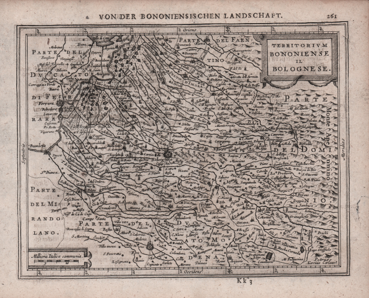
| Zone: | Bologna |
| Printed: | Amsterdam |
| Measures: | 204 x 155 mm |
| Reference: | S48172 |
| Author | Johannes JANSSONIUS |
| Year: | 1628 ca. |
| Zone: | Bologna |
| Printed: | Amsterdam |
| Measures: | 204 x 155 mm |
A miniature map taken from Atlas minor, Das ist: Eine kurtze, jedoch gründliche Beschreibung der gantzen Weldt. Engraved by Abraham Goos or Pieter van den Keere, first issued by Johannes Janssonius in 1628.
Mercator's Atlas Minor was conceived by Jodocus Hondius in 1607 as a reduced-sized edition of the popular folio-sized Mercator Atlas. The Atlas Minor was intended to be larger than a pocket atlas, yet smaller than the folio atlas, and were priced accordingly to reach a new market.
There were three different editions of the Atlas Minor published by different authors, each with a new set of copperplates. Jodocus Hondius published the first edition from 1607-1621, and subsequently sold the copperplates to parties in England between 1621-1625, after which an English edition was published using many of the original plates in 1635-39. Johannes Jansson wanted to compete in the small atlas market as well, and had new copperplates engraved by Pieter van den Keere and Abraham Goos for his own edition published in multiple languages between 1628-51. The third and final edition was published by Jan Evertsz. Cloppenburch (or Cloppenburg) between 1630-1734 (some without text), with new maps engraved primarily by Pieter van den Keere.
"Shortly after the publication of the big folio-atlases the need was apparantly felt for a smaller-sized atlas, one that would be handier, and, above all, cheaper, so that a larger public might have access to the use of maps. The publication of the Atlas Minor appeared to be a great success for Hondius; the first Latin edition was in great demand. The copperplates of the first atlases minor were most almost certainly engraved by Jodocus Hondius himself. After 1621, the copperplates of the Atlas Minor were sold to a London editor. Firstly, they appeared in Purchas his Pilgrinies, printed in 1625 by William Stansby for Henry Featherstone. Next they were used for the translation of the Mercator-atlas, printed in small folio under the title Historia mundi, or Mercators atlas, by Thomas Cotes for Michael Sparke and Samuel Cartwight in 1635". (cf. Koeman II Me 191).
"As with the Theatrum of Abraham Ortelius, Jodocus Hondius planned a reduced size version of Gerard Mercator's folio atlas. Just one year after his first edition he published his Latin text Atlas Minor in collaboration with Jan Jansz. and Cormelis Claesz. The arrangement between these three is not understood clearly but Hondius is believed to have been the owner of the copperplates. Cartographically this is taken directly from the folio maps by Hondius in 1606 [..]. with the inevitable loss of detail due to the reduction” (cf. Burden, The Mapping of North America, 153).
Johannes Janssonius (1588-1664) was the son of a printer, publisher and bookseller from Arnhem with the same name. In 1612 he married Elizabeth Hondius, daughter of Jodocus Hondius I, and in the same year set up his own publishing house in Amsterdam. When Jodocus I died that same year he began helping Hondius’ widow with the continued publication of the Mercator – Hondius atlas. Both Hondius’ widow, Colette, as well as Hondius’ eldest son, Jodocus II, died in 1629; Janssonius therefore joined forces with Hondius’ younger son, Henricus, to revise the Mercator-Hondius atlas, the ‘Atlas Novus’, from 1638.
Copperlate, very good condition. From the German edition of Atlas minor, printed in Amsterdam 1648.
Bibliografia
Koeman IIIB, 352:33.
Johannes JANSSONIUS (1588-1664)
|
Johannes Janssonius, more commonly known to us as Jan Jansson, was born in Arnhem where his father was a bookseller and publisher (Jan Janszoon the Elder). In 1612 he married the daughter of the cartographer and publisher Jodocus Hondius, and then set up in business in Amsterdam as a book publisher. In 1616 he published his first maps of France and Italy and from then onwards he produced a very large number of maps, perhaps not quite rivalling those of the Blaeu family but running a very close second in quantity and quality. From about 1630 to 1638 he was in partnership with his brother-in-law, Henricus Hondius, issuing further editions of the Mercator/Hondius atlases to which his name was added. On the death of Henricus he took over the business, expanding the atlas still further, until eventually he published an 11-volume Atlas Major on a scale similar to Blaeu's Atlas Major.
The first full edition of Jansson's English County Maps was published in 1646 but some years earlier he issued a number of British maps in the Mercator/Hondius/Jansson series of atlases (1636-44); the maps were printed from newly engraved plates and are different from the later 1646 issue and are now rarely seen (see Appendix B for further details).
In general appearance Jansson's maps are very similar to those of Blaeu and, in fact, were often copied from them, but they tend to be more flamboyant and, some think, more decorative.
After Jansson's death his heirs published a number of maps in an Atlas Contractus in 1666 and later still many of the plates of his British maps were acquired by Pieter Schenk and Gerard Valck, who published them again in 1683 as separate maps.
|