
| Reference: | ms2310 |
| Author | Jodocus HONDIUS Jr. |
| Year: | 1616 ca. |
| Zone: | Bohemia |
| Printed: | Amsterdam |
| Measures: | 135 x 100 mm |
| Reference: | ms2310 |
| Author | Jodocus HONDIUS Jr. |
| Year: | 1616 ca. |
| Zone: | Bohemia |
| Printed: | Amsterdam |
| Measures: | 135 x 100 mm |
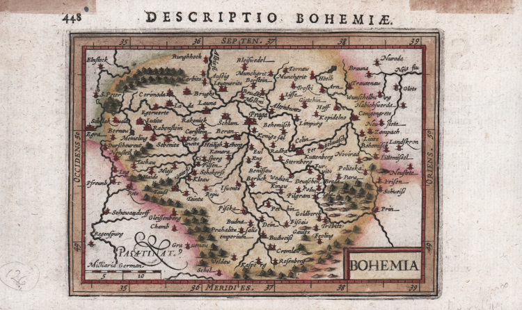
A miniature map depicting the Kingdom of Bohemia (the present-day western part of the Czech Republic), surrounded by its characteristic ring of mountains and forests ("Bohemian Forest"). In the center, the city of Prague stands out, traversed by the Vltava River (a tributary of the Elbe, labeled Albis flu. to the north). A rectangular cartouche bearing the inscription "BOHEMIA" appears in the lower right, while a graphic scale, expressed in German miles (Milliaria German.) is located in the lower left. The four cardinal directions are indicated in Latin along the graduated borders (*Septentrio* to the north, *Meridies* to the south, *Oriens* to the east, and *Occidens* to the west).
Cartographically, it is based on a map by Barent Langenes, published by Cornelis Claesz in 1598. It was engraved by Jodocus Hondius Jr. to illustrate the 1616 Latin edition of Petrus Bertius’s Tabularum Geographicarum Contractarum Libri Septem.
The work contains 219 maps illustrating this revised version of Bertius’s geography - first published in 1612, which also featured maps by Barent Langenes. Many of these maps are derived from the large Mercator/Hondius atlas, often appearing as scaled-down versions of the originals.
“After the death of Cornelis Claesz in 1609, Jodocus Hondius II became the new publisher of the work, composed by 7 parts in 1, with engraved title-page and 220 full-page engraved maps in text. All the maps were newly engraved and slightly larger in size, because Hondius was not able to acquire the original plates. With the new plates the work was definitely improved and enjoyed a growing demand of the public, which at that time had the choice between the Atlas Minor by Mercator and Bertius' Tabularum Geographicarum. The 219 plates, with the oval world map appearing twice, were produced to illustrate a new version of the geography of Bertius, published in 1616. According to King, their correct attribution is by Hondius, after Mercator and Hondius, taken from Bertius, who was only responsible for revising his text again” [cf. G. King, Miniature Antique Maps].
Copperplate with fine later hand colour, in good conditions.
|
Koeman p. 42; King p. 96/99.
|
Jodocus HONDIUS Jr. (Amsterdam 1594 -1629)
|
Jodocus Hondius Jr. was born in 1593, and his earliest signed publication was a map of Scandinavia, issued in 1613. Son of Jodocus Hondius (1563-1612) - engraver, cartographer, printer and publisher – founder of the Hondius typography, that was one of the most important of the time, even thanks to the collection of Mercator’s plates and the pubblication of many charts and atlases. In 1604, Hondius bought the copperplates of Mercator’s Atlas at the auction of Gerard Jr.’s effects. He added another forty maps, including new maps of the Continents and important regional maps of the Americas, before publishing a new edition of the Atlas, in 1606, in competition with Ortelius’ Theatrum. As many of the maps were more up-to-date, the Mercator-Hondius Atlas effectively superseded Ortelius’ Theatrum. On his death in 1612 his widow, Coletta van den Keere continued the business with his two childs; Jodocus Jr. and Hendrick (1597-1651) took over. In June 1621, Jodocus Jr. married Anne Staffmaecker, and moved into a shop on the Dam, where he established his own publishing business. From the period 1621 onwards, Jodocus Jr. published a small number of maps, including several "figured border" maps, including maps of the four continents, the British Isles and Brabant. In 1618 Jodocus Jr. published the important map "Nova Virginiae Tabula", engraved by Dirk Grijp, being the first and most important derivative of John Smith's map of Virginia originally published in 1612. (Burden, America, 193). Other engravers who worked for Hondius are Abraham Goos, Salomon Rogiers, Evert Sijmonsz van Hamersveldt. Very little is known about the cooperation between the Hondius' brothers and their brother-in-law. Aside from the partnership in the continuation of Jodocus Sr's workshop (1612), it seems all three successively started their own businnes. However, from the map of Orange of 1627, it appears that a cooperation certainly extended as far as that year, as the map has a dedication by Jud. et Henr. Hondius to Frederick Henry. According to Peter van the Krogt (cf. Atlantes Neerlandici) Jodocus Hondius Jr. and his younger brother Henricus Hondius where competitors.
|
|
Koeman p. 42; King p. 96/99.
|
Jodocus HONDIUS Jr. (Amsterdam 1594 -1629)
|
Jodocus Hondius Jr. was born in 1593, and his earliest signed publication was a map of Scandinavia, issued in 1613. Son of Jodocus Hondius (1563-1612) - engraver, cartographer, printer and publisher – founder of the Hondius typography, that was one of the most important of the time, even thanks to the collection of Mercator’s plates and the pubblication of many charts and atlases. In 1604, Hondius bought the copperplates of Mercator’s Atlas at the auction of Gerard Jr.’s effects. He added another forty maps, including new maps of the Continents and important regional maps of the Americas, before publishing a new edition of the Atlas, in 1606, in competition with Ortelius’ Theatrum. As many of the maps were more up-to-date, the Mercator-Hondius Atlas effectively superseded Ortelius’ Theatrum. On his death in 1612 his widow, Coletta van den Keere continued the business with his two childs; Jodocus Jr. and Hendrick (1597-1651) took over. In June 1621, Jodocus Jr. married Anne Staffmaecker, and moved into a shop on the Dam, where he established his own publishing business. From the period 1621 onwards, Jodocus Jr. published a small number of maps, including several "figured border" maps, including maps of the four continents, the British Isles and Brabant. In 1618 Jodocus Jr. published the important map "Nova Virginiae Tabula", engraved by Dirk Grijp, being the first and most important derivative of John Smith's map of Virginia originally published in 1612. (Burden, America, 193). Other engravers who worked for Hondius are Abraham Goos, Salomon Rogiers, Evert Sijmonsz van Hamersveldt. Very little is known about the cooperation between the Hondius' brothers and their brother-in-law. Aside from the partnership in the continuation of Jodocus Sr's workshop (1612), it seems all three successively started their own businnes. However, from the map of Orange of 1627, it appears that a cooperation certainly extended as far as that year, as the map has a dedication by Jud. et Henr. Hondius to Frederick Henry. According to Peter van the Krogt (cf. Atlantes Neerlandici) Jodocus Hondius Jr. and his younger brother Henricus Hondius where competitors.
|