
| Reference: | S49238.224 |
| Author | Georg BRAUN & Franz HOGENBERG |
| Year: | 1617 |
| Zone: | Louny, Slany |
| Printed: | Antwerpen & Cologne |
| Measures: | 480 x 365 mm |
| Reference: | S49238.224 |
| Author | Georg BRAUN & Franz HOGENBERG |
| Year: | 1617 |
| Zone: | Louny, Slany |
| Printed: | Antwerpen & Cologne |
| Measures: | 480 x 365 mm |
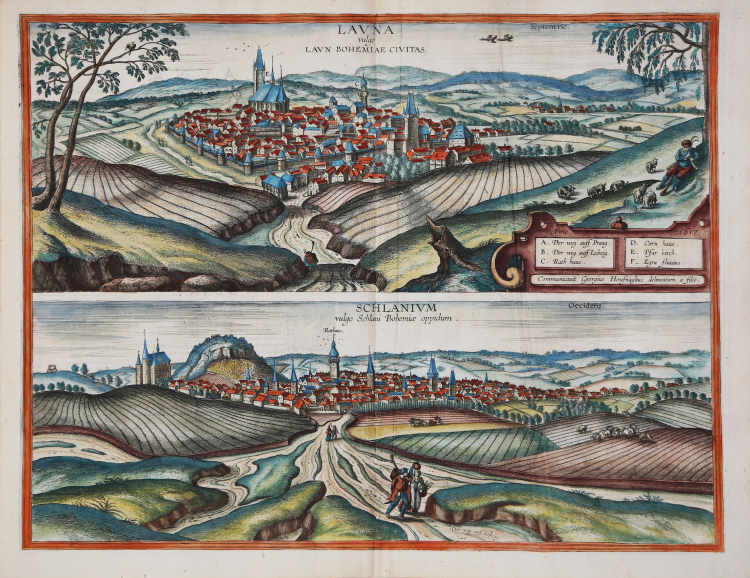
View of Louny an Schlanium, from the sixth volume of Civitates Orbis Terrarum, edited in 1617. This view of Louny is from the southeast from a slightly elevated viewpoint shows the well-fortified north Bohemian town situated close to the River Ohre. Louny is dominated by three large buildings: the gatetower on the right, the church of St Nicholas (E) with its 14th-century bell tower and late Gothic nave that was rebuilt by Benedikt Ried from 1520 to 1538 after the town was destroyed by fire, and the town hall (C) between these two buildings. The town of Schlanium is presented from the north from a slightly elevated position. It is dominated by the hill from which it takes its name, which can be seen on the left, and to the left of that church of the holy Trinity. The tower of the town hall stands out clearly in the middle.
This view comes from the sixth and last volume of the 'Civitates Orbis Terrarum' ("Theatri Praecipuarum Totius Mundi Urbivm Liber Sextus"), published in a much smaller edition than previous volumes, and it is, therefore, rarer than most of Braun & Hogenberg city views, published by A. Hierat in Cologne, 1618.
The first volume of the Civitates Orbis Terrarum was published in Cologne in 1572. The sixth and the final volume appeared in 1617. This great city atlas, edited by Georg Braun and largely engraved by Franz Hogenberg, eventually contained 546 prospects, bird-eye views and map views of cities from all over the world. Fransz Hogenberg produced the plates for the first four books, and Simon van den Neuwel (Novellanus, active since 1580) those for volumes V and VI.
Georg Braun (1541-1622), a cleric of Cologne, was the principal editor of the work, and was greatly assisted in his project by the close, and continued interest of Abraham Ortelius, whose Theatrum Orbis Terrarum of 1570 was, as a systematic and comprehensive collection of maps of uniform style, the first true atlas. The Civitates, indeed, was intended as a companion for the Theatrum, as indicated by the similarity in the titles and by contemporary references regarding the complementary nature of two works. Nevertheless, the Civitates was designs to be more popular in approach, no doubt because the novelty of a collection of city plans and views represented a more hazardous commercial undertaking than a world atlas, for which there had been a number of successful precedents. Franz Hogenberg (1535-1590) was the son of a Munich engraves who settled in Malines. He engraved most of the plates for Ortelius's Theatrum and the majority of those in the Civitates and may have been responsible for originating the project.
Over a hundred of different artists and cartographers, the most significant of whom was Antwerp artist Georg Hoefnagel (1542-1600), engraved the cooper-plates of the Civitates from drawings. He not only contributed most of the original material for the Spanish and Italian towns but also reworked and modified those of other contributors. After Hoefnagel's death his son Jakob continued the work for the Civitates.
The author set out to depict "non icones et typi urbium," that is, not generic and typified images, "sed urbes ipsae admirabili caelaturae artificio, spectantium oculis subiectae appareant": not intended to allude or idealize but to represent faithfully on paper, to reproduce exactly, and in real time, what the eye sees, as announced in the preface to the first volume of Civitates Orbis Terrarum.
Copperplate engraving with fine hand colour, in very good condition.
Bibliografia
Van der Krogt 4, 2474.
|
George Braun (1541-1622), cleric of Cologne, was the principal editor of the Civitates Orbis Terrarum, and was greatly assisted in his project by the close, and continued interest of Abraham Ortelius, whose Theatrum Orbis Terrarum of 1570 was, as a systematic and comprehensive collection of maps of uniform style, the first true atlas.
Franz Hogenberg (1535-1590) was the son of a Munich engraves who settled in Malines. He engraved most of the plates for Ortelius's Theatrum and the majority of those in the Civitates, and may have been responsible for originating the project.
|
|
George Braun (1541-1622), cleric of Cologne, was the principal editor of the Civitates Orbis Terrarum, and was greatly assisted in his project by the close, and continued interest of Abraham Ortelius, whose Theatrum Orbis Terrarum of 1570 was, as a systematic and comprehensive collection of maps of uniform style, the first true atlas.
Franz Hogenberg (1535-1590) was the son of a Munich engraves who settled in Malines. He engraved most of the plates for Ortelius's Theatrum and the majority of those in the Civitates, and may have been responsible for originating the project.
|