
| Reference: | S39342 |
| Author | Ferrando BERTELLI |
| Year: | 1568 |
| Zone: | Antwerp |
| Measures: | 315 x 195 mm |
| Reference: | S39342 |
| Author | Ferrando BERTELLI |
| Year: | 1568 |
| Zone: | Antwerp |
| Measures: | 315 x 195 mm |
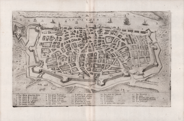
In the upper center, in the sea, the title: ANVERSA. Along the lower edge, on five columns, a numerical legend of 29 references to notable places and monuments. Map without orientation and graphic scale.
Anonymous map, without editorial indications, depicting the city of Antwerp with its new citadel, designed in 1567 by Francesco Paciotto and completed in 1572. Immediately after its first compilation (September-October 1567), the project of the citadel began to circulate in Europe and Hieronimus Cock amended his printed map of the city (1557) to include the new fortification.
The new version is dated to late 1567 or soon after. A woodcut by Pauwels van Overbecke is also known, dated 1568 (Antwerp, Stadsarchief). the project did not take long to circulate in the printing houses of the peninsula, as this Italian copy proves. The plate is known only in very few copies, which the literature dates around 1570. The legend at the bottom is taken from the Forlani map, with respect to which a new entry is added (The fortress at number 29); the entry for the town hall, shown in plan, is not included. The attribution to Bertelli is proposed by us both for stylistic reasons (the similarities with other medium-small sized charts of Ferrando Bertelli's typography are evident), and because the specimen preserved in the sixteenth century collection belonging to Alessandro d'Este, is printed on a sheet containing also the view of Lyon (cat. no. 423) which is definitely to be assigned to Ferrando Bertelli as part of his Civitatum aliquot insigniorum et locorum, magis munitorum exacta delineatio: cum additione aliquot insularum principalium.” (cfr. Bifolco-Ronca p. 867).
Etching and engraving, printed on contemporary laid paper, with margins, in perfect condition.
Very rare.
Bibliography
Bifolco-Ronca, Cartografia e topografia italiana del XVI Secolo (2018): p. 867, Tav. 312; Meurer (2002): nn. 124, 147; Tavernari (2014): n. 140; Fauser (1978): n. 517; Martens (2016): p. 15, nota 46 e tav. 18; Nordenskiöld (1981): n. 12(63); cfr. Valerio (1998): p. 43, n. 63.
Ferrando BERTELLI (attivo a Venezia seconda metà del XVI secolo)
|
Bertelli family represents the largest group of publishers, engravers, cartographers and merchants of prints of the sixteenth century. Ferrando Bertelli was the most productive, active between 1570, the 1560th, but maps of the last quarter of the century are known by the names of Andrea, Donato, Lucca, Nicholas and Peter. This was mainly active in Padua, where he led a workshop in letterpress and engravings. The earliest records show the asset at the date of 1589 as an engraver of several plates for an edition entitled Diversarum nationum habitus which was published in collaboration with Alciato Alciati. Pietro Bertelli had a library in Padua "the banner of the Angel". At his death the business was inherited by his son Francis. Bertelli was wandering engraver, copperplate engraver and publisher, print dealer active in Venice between 1561 and 1572. We do not have the precise biographical Bertelli.
He teamed with Camocio and the Forlani for the edition and trade cards and plants, they should also become the core business of spreading in the city by Italian and foreign ones, increasing the development of cartography. As a publisher chalcographer emerged from his workshop papers invention of Giacomo Gastaldi, Pirro Ligorio etc.. Although numerous papers of Drawings of the most illustrious cities and fortresses in the world (Venice 1568) bear his signature. Of 1572 is his last edition, the famous islands, harbors, fortresses … Sig.ria subject to Venice, a collection of 88 maps and charts, loose and perhaps already published some of them attributable to the engraving by Martin Rota Sibenik . Later, Ferrando mapss were reprinted by Donato Bertelli (by which we can not determine whether there were family ties) and Donato Rascicotti. Bibliography: Valerio, Cartographers Veneti, p. 149.
|