| Reference: | S40097 |
| Author | Johannes COVENS |
| Year: | 1715 ca. |
| Zone: | Amsterdam |
| Printed: | Amsterdam |
| Measures: | 970 x 566 mm |
| Reference: | S40097 |
| Author | Johannes COVENS |
| Year: | 1715 ca. |
| Zone: | Amsterdam |
| Printed: | Amsterdam |
| Measures: | 970 x 566 mm |
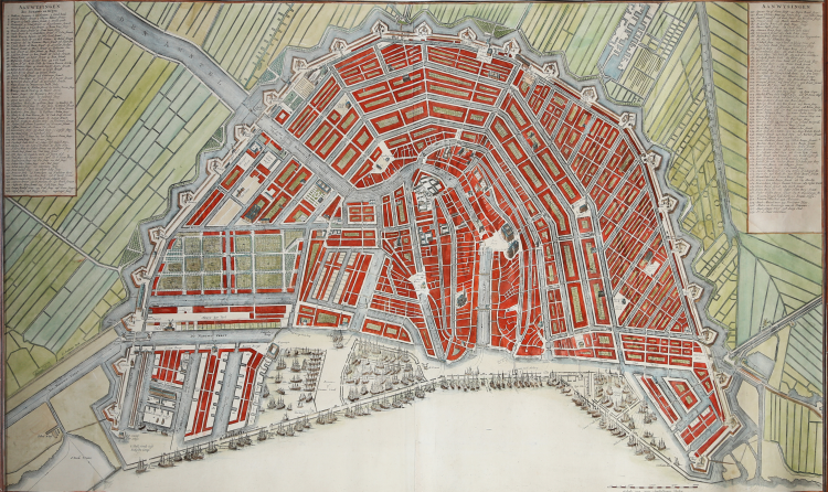
Sixth and final state of this rare, two-sheet bird’s-eye plan of Amsterdam first issued in 1715 by Nicolas Visscher with a decorative title cartouche - features putti, garlands of fruit, and the coat of arms of Amsterdam – at the bottom.
The map is based on the city plan compiled in 1662 by architect Daniel Stalpaert and published by Nicolas Visscher, which recorded the addition of the Ring Canals to the city that had begun in 1613. The plan shows the streets, canals, locks, city blocks, and a number of important landmarks in great detail. The streets are numbered and keyed to columns flanking the map, listing an impressive 299 streets. The city is divided into 14 districts, which are numbered with gilt highlights. Dozens of galleons fill the waterfront, demonstrating the importance of Dutch trade at the time, and numerous windmills surround the city.
Printed on two sheets, joined as issued.
Copperplate with fine later hand colour, in good condition.
|
M. Hameleers, Kaarten van Amsterdam, 104.
|
|
Johannes Covens (1697-1774) was a Dutch geographic publisher based in Amsterdam. He is best known for his collaboration with fellow publisher Cornelis Mortier (1699-1783). Pierre Mortier the Elder (1661-1711) had obtained a privilege in 1690 to distribute the works of French geographers in the Netherlands. After his widow continued the business for several years, Cornelis took over in 1719.
In 1721, Mortier forged a partnership with Covens, who had recently married Cornelis’ sister. They published under the joint name of Covens & Mortier. In 1774, upon the death of his father, Johannes Covens II (1722-1794) took over his father’s share. In 1778, the company changed its name to J. Covens & Zoon, or J. Covens & son.
Covens II’s son, Cornelis (1764-1825), later inherited the business and brought Petrus Mortier IV back into the fold. Petrus was the great-grandson of Petrus Mortier I. From 1794, the business was called Mortier, Covens & Zoon, or Mortier, Covens, & Son.
The business specialized in publishing French geographers including Deslisle, Jaillot, and Sanson. They also published atlases, for example a 1725 reissue of Frederik de Wit’s Atlas Major and an atlas, with additions, from the works of Guillaume Delisle. There were also Covens & Mortier pocket atlases and town atlases. The company profited from acquiring plates from other geographers as well. For example, the purchased Pieter van der Aa’s plates in 1730. Finally, they also compiled a few maps in house. At their height, they had the largest collection of geographic prints ever assembled in Amsterdam.
|
|
M. Hameleers, Kaarten van Amsterdam, 104.
|
|
Johannes Covens (1697-1774) was a Dutch geographic publisher based in Amsterdam. He is best known for his collaboration with fellow publisher Cornelis Mortier (1699-1783). Pierre Mortier the Elder (1661-1711) had obtained a privilege in 1690 to distribute the works of French geographers in the Netherlands. After his widow continued the business for several years, Cornelis took over in 1719.
In 1721, Mortier forged a partnership with Covens, who had recently married Cornelis’ sister. They published under the joint name of Covens & Mortier. In 1774, upon the death of his father, Johannes Covens II (1722-1794) took over his father’s share. In 1778, the company changed its name to J. Covens & Zoon, or J. Covens & son.
Covens II’s son, Cornelis (1764-1825), later inherited the business and brought Petrus Mortier IV back into the fold. Petrus was the great-grandson of Petrus Mortier I. From 1794, the business was called Mortier, Covens & Zoon, or Mortier, Covens, & Son.
The business specialized in publishing French geographers including Deslisle, Jaillot, and Sanson. They also published atlases, for example a 1725 reissue of Frederik de Wit’s Atlas Major and an atlas, with additions, from the works of Guillaume Delisle. There were also Covens & Mortier pocket atlases and town atlases. The company profited from acquiring plates from other geographers as well. For example, the purchased Pieter van der Aa’s plates in 1730. Finally, they also compiled a few maps in house. At their height, they had the largest collection of geographic prints ever assembled in Amsterdam.
|