
| Reference: | s21219 |
| Author | Gabriello DE SANCTIS |
| Year: | 1856 |
| Zone: | Basilicata |
| Printed: | Naples |
| Measures: | 355 x 425 mm |
| Reference: | s21219 |
| Author | Gabriello DE SANCTIS |
| Year: | 1856 |
| Zone: | Basilicata |
| Printed: | Naples |
| Measures: | 355 x 425 mm |
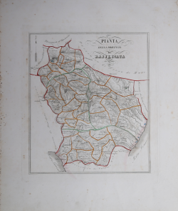
Map taken from the rare Atlante Corografico del Regno delle Due Sicilie tratto dalla Gran Carta d' Italia dedicato ad Adriano Balbi alla scala di 1/5 e corretto nella divisione amministrativa Civile Giudiziaria e Diocesana e nella indicazione delle strade rotabili di ultima costruzione published in Naples in 1856.
Gabriello De Sanctis was the author of the Atlante Corografico del Regno delle Due Sicilie, published in Naples (three editions between 1840 and 1856), with 27 magnificent maps.
The maps in this collection dedicated to Adriano Balbi are a reduction of that in Atlante Corografico del Regno delle Due Sicilie.
The material he used for the compilation was the two atlases, made by Benedetto Marzolla and Luigi De Salvatori. In fact, De Sanctis was neither geographer nor topographer, and his atlas is first and foremost a work of compilation. The plates, devoid of a geographical grid, are true exercises in graphic design and calligraphy, making the work one of the finest atlases of the century. They also reflect his interest in statistical data. Each plate is adorned with the coat of arms of the province represented.
Copperplate engraving with contempporary coloring of the outlines, slight oxidation of the paper, otherwise in excellent condition.
|
Was the author of “Atlante Corografico del Regno delle Due Sicilie”, published in Naples. The atlas included 27 beautiful maps.
|
|
Was the author of “Atlante Corografico del Regno delle Due Sicilie”, published in Naples. The atlas included 27 beautiful maps.
|