
| Reference: | S39534 |
| Author | Adam Friedrich ZURNER |
| Year: | 1700 ca. |
| Zone: | Asia |
| Printed: | Amsterdam |
| Measures: | 590 x 515 mm |
| Reference: | S39534 |
| Author | Adam Friedrich ZURNER |
| Year: | 1700 ca. |
| Zone: | Asia |
| Printed: | Amsterdam |
| Measures: | 590 x 515 mm |
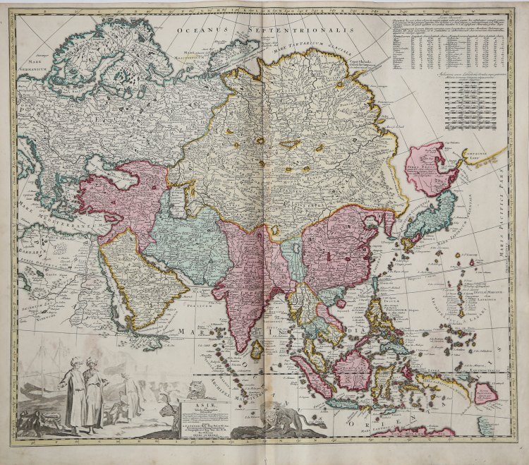
Asiae in Tabula Geographica Delineatio : admentem novissimorum eorumque optimorum geographorum emendata, indicibus utilissimis aucta et adusum Tyronum imprimis geographicorum variis compendiosae methodi adminiculis accomodata. Opera A.F. Zurneri ... Ex officina Petri Schenkii. In Platea vulgo de Warmoes straat sub signo N. Visscher athlas.
Very fine, and very scarce of map of Asia.
Zurner produced maps for both Homann and Schenk, as well publishing his own maps.
The northeast coastline is shown with Witsen's information on Siberia. Hokkaido and Honshu (Terra Yedso) are joined together by a narrow isthmus and separated from the mainland by a wide straight. An accompanying note acknowledges Scherer as the source, although the orientation of Yedso and Companies Land appears to be based on the Delisle model. A huge lake appears in Tibet and is named the legendary Chiamay. A second lake is shown in the position usually occupied by Lake Chiamay, but here it is named L. Cananor Cimabete. In Southeast Asia the straits between New Guinea and Australia appear in a tentative fashion, noting Dampier's Strait and a disembodied Carpenteria with no definite northern limit.
The map is decorated with a large, uncolored cartouche featuring Arab merchants, a fort, a pair of leopards and a fierce lion.
Beautifully, contemporary coloured engraved map.
According to the text on the cartouche: "ex officina Petri Schenkii in platea vulgo de Warmoes straat sub signo N. Visschers athlas".
Adam Friedrich ZURNER (1679 - 1742)
|
Adam Friedrich Zürner was a German engraver, pastor and scientist based in Dresden Germany. His is known to have worked with the Homann Heirs firm as well as several other cartographic firms of the era. His cartographic work primarily focuses on Saxony and parts of Germany. Zurner's first project of note was a map of Saxony, for which he was retained by August III, King of Poland, in 1711.
Zurner was appointed Geographer of Poland and the Electorate of Saxony, a position in which he served until 1732. In this time period, he reportedly traveled nearly 18,000 miles and created over 900 maps.
In 1721, he was tasked with establishing a postal road system in Saxony and marking the distances with stone posts.
His work resulted in the Atlas Augusteus Sauronicus (40 maps plus key sheet), which remained incomplete until after Zurner's death, but was ultimately sold to Pieter Schenk in Amsterdam in about 1745. Schenk's completed work (49 maps, published in Amsterdam and Leipzig) was issued without reference to Zurner's name, under the title Atlas Saxonicus.
|