| Reference: | MS4028 |
| Author | Nicolas DE FER |
| Year: | 1689 ca. |
| Zone: | Asia |
| Printed: | Paris |
| Measures: | 160 x 145 mm |
| Reference: | MS4028 |
| Author | Nicolas DE FER |
| Year: | 1689 ca. |
| Zone: | Asia |
| Printed: | Paris |
| Measures: | 160 x 145 mm |
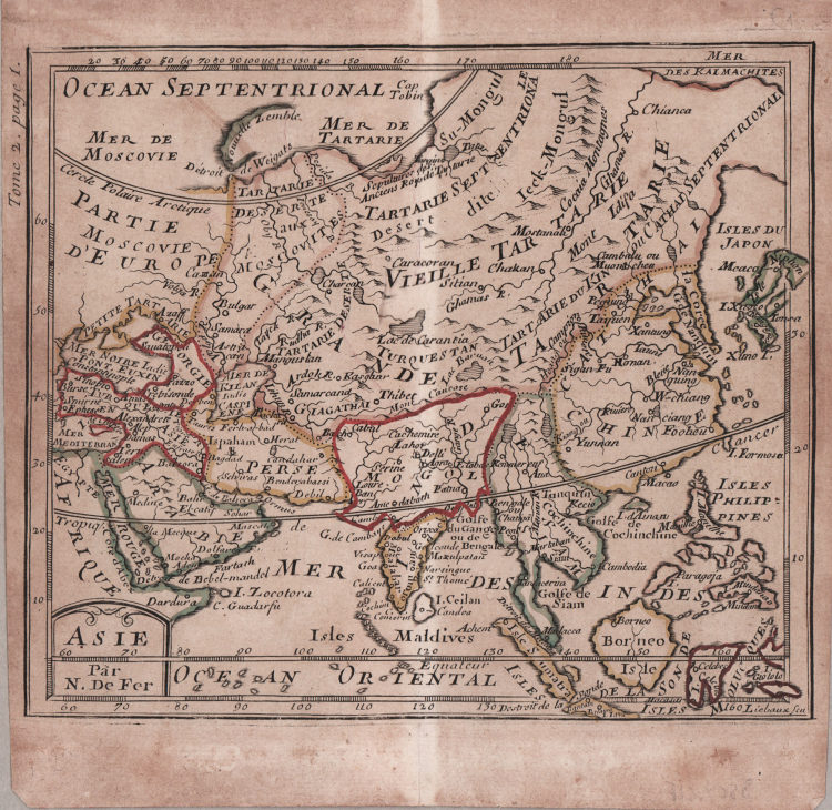
Map taken from "Methode pour Apprendre Facilement la Geographie" by Nicolas de Fer, first published in 1689.
Geographic misconceptions continue on this map, with a very elongated Korean peninsula and the mythical (but here unnamed) Chimay Lacus, with four rivers flowing south. Japan has an odd shape, and the Kamchatka Peninsula extends indefinitely to the east.
From the 1717 edition of the "Methode pour Apprendre Facilement la Geographie".
Copperplate,original outline colour, good condition.
Nicolas DE FER (1646-1720 circa)
|
One of the most prolific and influential French geographers and cartographers of the late 17th and early 18th Century. Nicolas was the youngest son of Parisian print and mapseller, Antoine de Fer [d.1673]. He produced numerous atlases: Atlas Curieux [1700-5] and its subsequent suites; Atlas ou Receuil des Cartes [1709]; Atlas Royale [1699]; Les Beautés de la France [1708]; Atlases detailing wars and countries relating to the Spanish succession [1701]; Italy [1702] & Germany [1705] and Franco-Belgian frontiers [1708-10]; Les Forces de L'Europe [1690-95]; Introduction à la Géographie [1708]; the Petit Nouveau Atlas [1697]. Aswell as his Atlas output de Fer is also well known for his large Wall maps, some 26 in total, aswell as large-scale town plans of European cities, and a signifcant output of thematic printed card games. His sign and emblem was the Sphère Royale, originally that of Melchior Tavernier, to which he was greatly attached and which appears on a large number of his works. He died on 25th October 1720 and his estate was divided between his three daughters, all three of whose husbands were closely involved in the Parisian engraving and publishing business : Guillaume Danet, Remi Richer, Jaques-Francois Besnard or Bénard. A number of de Fer's maps and atlases continued to be published by his heirs for another twenty or thirty years.
|