| Reference: | S36135 |
| Author | Mattheus QUAD |
| Year: | 1600 |
| Zone: | North Pole |
| Printed: | Cologne |
| Measures: | 280 x 220 mm |
| Reference: | S36135 |
| Author | Mattheus QUAD |
| Year: | 1600 |
| Zone: | North Pole |
| Printed: | Cologne |
| Measures: | 280 x 220 mm |
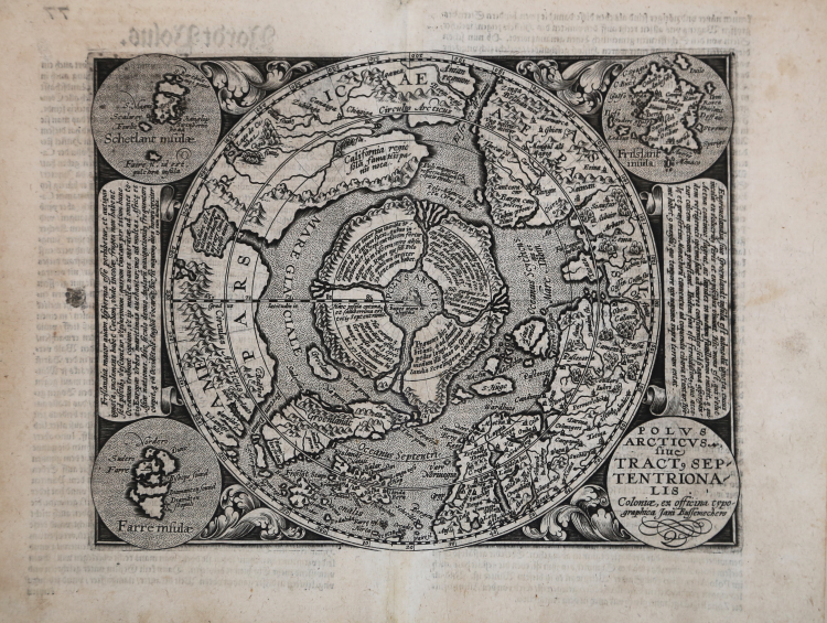
Important early map of the North Polar regions, based upon Mercator's map of 1595.
The North Pole is shown according to legend as a large rock in a giant whirlpool and surrounded by four islands that are separated by rivers. The magnetic north is depicted as a separate island rock just outside the polar mass. In North America is an very early reference to California (California regio, sola fama Hispanis nota), curiously shown north of the El streto de Anian. The map depicts the attempts of Frobisher and Davis to locate the northern passages to Asia.
The map image is surrounded by a floral design with four roundels in each corner. These contain the title, the Faeroe Isles, the Shetland Isles, and the mythical island of Frisland.
|
Burden, P.D. 134; Meurer, P.H. (Cologne) Qua 79
|
Mattheus QUAD (Deventer 1557 - Colonia 1613)
|
As it often appened then, to escape from Catholic persecution, Protestants, and Matthias Quad among them, used many alias for their work. The most famous used by the artis were C. Eichovius, M. Quadus, M. Quad von Kinckelbach and Konrad Loew. Quad escaped from Holland to Germany in 1587, studied in Heidelberg and afterwards became one of the most prolific artists of the Cartographic School of Cologne, whose activity lasted for 150 years (1570-1620 ca.). The school was basically built up by Flemish and Dutch artists escaping from persecution, among them also Frans Hogenberg, the founder of the school. In 1594 Quad published in Cologne Europae, totius terrarum orbis partis praestantissimae descriptio. In 1596 approximately, and again in Cologne, he published Typus Orbis Terrarum, ad Imitationem Universalis Gerhardi Mercatoris, a world map based on Marcator’s work but in 1600 he published his personal, indipendent world atlas, the Geographisch Handtbuch, which is also the first one published in German. In 1608 a Latin edition was issued, Fasciculus Geographicus, with four unpublished maps engraved by Johann Bussemacher, his collaborator. Due to his multiple alias, his huge production is still to be completely identified. Quad’s maps did not enjoy great success for they were published the same period of Ortelius’ atlases; for that reason, there is not a second edition known of Quad’s work, which makes his first one vary rare and sought-after.
1592 Europae totius orbis terrarium (small folio)
1594 and 1596 re-issued
c.1600 Geographisch handtbuch
1608 maps re-issued in Fasciculus geographicus(small folio)
|
|
Burden, P.D. 134; Meurer, P.H. (Cologne) Qua 79
|
Mattheus QUAD (Deventer 1557 - Colonia 1613)
|
As it often appened then, to escape from Catholic persecution, Protestants, and Matthias Quad among them, used many alias for their work. The most famous used by the artis were C. Eichovius, M. Quadus, M. Quad von Kinckelbach and Konrad Loew. Quad escaped from Holland to Germany in 1587, studied in Heidelberg and afterwards became one of the most prolific artists of the Cartographic School of Cologne, whose activity lasted for 150 years (1570-1620 ca.). The school was basically built up by Flemish and Dutch artists escaping from persecution, among them also Frans Hogenberg, the founder of the school. In 1594 Quad published in Cologne Europae, totius terrarum orbis partis praestantissimae descriptio. In 1596 approximately, and again in Cologne, he published Typus Orbis Terrarum, ad Imitationem Universalis Gerhardi Mercatoris, a world map based on Marcator’s work but in 1600 he published his personal, indipendent world atlas, the Geographisch Handtbuch, which is also the first one published in German. In 1608 a Latin edition was issued, Fasciculus Geographicus, with four unpublished maps engraved by Johann Bussemacher, his collaborator. Due to his multiple alias, his huge production is still to be completely identified. Quad’s maps did not enjoy great success for they were published the same period of Ortelius’ atlases; for that reason, there is not a second edition known of Quad’s work, which makes his first one vary rare and sought-after.
1592 Europae totius orbis terrarium (small folio)
1594 and 1596 re-issued
c.1600 Geographisch handtbuch
1608 maps re-issued in Fasciculus geographicus(small folio)
|