| Reference: | s34965 |
| Author | Henrick SCHERER |
| Year: | 1703 |
| Zone: | North Pole |
| Printed: | Munich |
| Measures: | 356 x 238 mm |
| Reference: | s34965 |
| Author | Henrick SCHERER |
| Year: | 1703 |
| Zone: | North Pole |
| Printed: | Munich |
| Measures: | 356 x 238 mm |
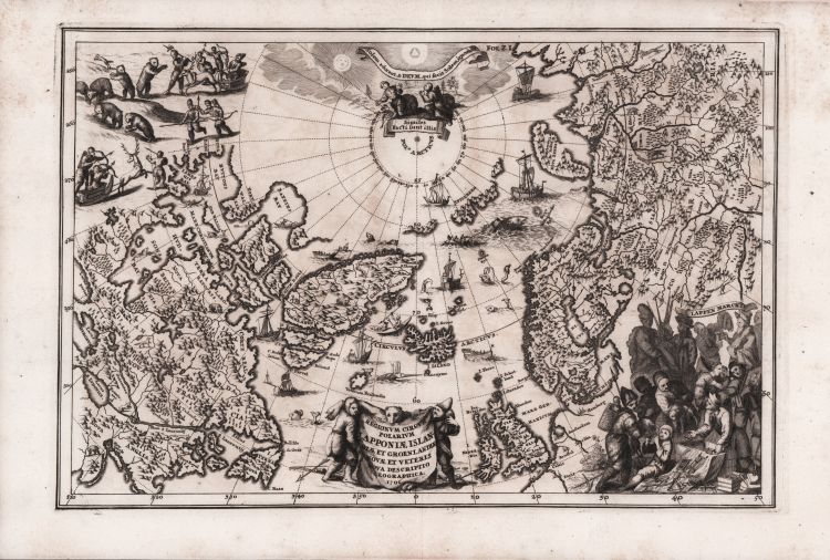
Fascinating map of the North Pole by Heinrich Scherer (1628-1704) for his Atlas Novus exhibens orbem terraguem per naturae opera, historiae navae acveterus monumenta, artistique geographicae leges et praecepta...published in eight volumes from 1702-1710 in Munich.
Scherer, a devout Jesuit, produced this geographical compendium to depict the Catholic hierarchy and the spread of Jesuit missions throughout the world.
The map itself presents typical cartography for the period, leaving open the possibility of both a Northeast and Northwest Passage to the Far East. The map is literally filled with images of sea monsters, whaling, hunting and exploration.
The title cartouche is engraved onto the hide of a polar bear with two hunters, and at right is a vignette of the people of Lapland.
Copper etching, some light stains, otherwise in good condition.
Henrick SCHERER (Dilingen 1628 - Monaco 1704)
|
Heinrich Scherer was a devout Jesuit, and professor of mathematics at Munich. His 'Atlas Novus' contained maps of all other parts which showed the spread of Catholicism and Jesuit missions.
|
Henrick SCHERER (Dilingen 1628 - Monaco 1704)
|
Heinrich Scherer was a devout Jesuit, and professor of mathematics at Munich. His 'Atlas Novus' contained maps of all other parts which showed the spread of Catholicism and Jesuit missions.
|