| Reference: | W12762 |
| Author | Johannes JANSSONIUS |
| Year: | 1637 ca. |
| Zone: | North Pole |
| Printed: | Amsterdam |
| Measures: | 540 x 420 mm |
| Reference: | W12762 |
| Author | Johannes JANSSONIUS |
| Year: | 1637 ca. |
| Zone: | North Pole |
| Printed: | Amsterdam |
| Measures: | 540 x 420 mm |
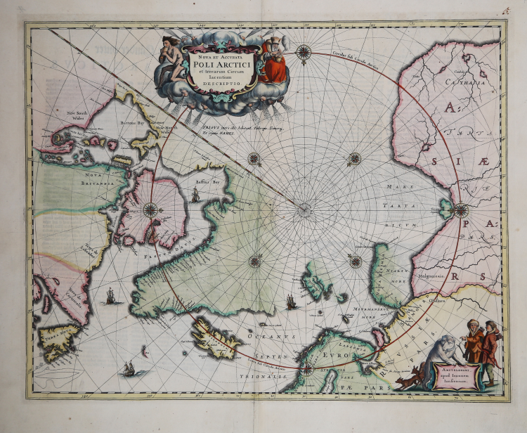
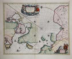
This beautiful map, originally published in 1637, eventually replaced Hondius' map of the North Pole and became the prototype for many later maps including those of Blaeu.
This map incorporates the discoveries made by Captain Thomas James along the southern and western shores of Hudson Bay in 1631-2.
The delineation on Russia's Arctic coast is derived from the information from Willem Barents' exploration of 1596-7. The English explorer Hugh Willoughby has a small island named after him off the coast of Lapland (Sir Hugo Willoughby's Landt).
Willoughby captained an expedition of three ships to find a Northeast Passage in 1553, but two of the ships were ripped away during a storm. Willoughby and his crew from the two ships died and were found on Novaya Zemla the following year, with his journal. The third ship with his second-in-command Richard Chancellor made it to Russia. Rhumb lines radiate from the North Pole and several compass roses embellish the chart. A large title cartouche, with two figures and numerous wind heads, conveniently hide the northwest coast of America.
Joannes Janssonius (Arnhem, 1588-1664), son of the Arnhem publisher Jan Janssen, married Elisabeth Hondius, daughter of Jodocus Hondius, in Amsterdam in 1612. After his marriage, he settled down in this town as a bookseller and publisher of cartographic material. In 1618 he established himself in Amsterdam next door to Blaeu’s book shop. He entered into serious competition with Willem Jansz. Blaeu.. His activities not only concerned the publication of atlases and books, but also of single maps and an extensive book trade with branches in Frankfurt, Danzig, Stockholm, Copenhagen, Berlin, Koningsbergen, Geneva, and Lyon. In 1631 he began publishing atlases together with Henricus Hondius. In the early 1640s Henricus Hondius left the atlas publishing business completely to Janssonius. Competition with Joan Blaeu, Willem’s son and successor, in atlas production prompted Janssonius to enlarge his Atlas Novus finally into a work of six volumes, into which a sea atlas and an atlas of the Old World were inserted. After the death of Joannes Janssonius, the shop and publishing firm were continued by the heirs under the direction of Johannes van Waesbergen (c. 1616-1681), son-in-law of Joannes Janssonius. The copperplates from Janssonius’s atlases were afterwards sold to Schenk and Valck.
The map is further decorated with ships and a cartouche with Jansson’s imprint, which depicts men in parkas, a polar bear and foxes. This example is the fourth state of the plate with Nova Zemla connected to the mainland with a land bridge and the completed coastline of Spitzbergen. German text on verso.
Very good condition.
Johannes JANSSONIUS (1588-1664)
|
Johannes Janssonius, more commonly known to us as Jan Jansson, was born in Arnhem where his father was a bookseller and publisher (Jan Janszoon the Elder). In 1612 he married the daughter of the cartographer and publisher Jodocus Hondius, and then set up in business in Amsterdam as a book publisher. In 1616 he published his first maps of France and Italy and from then onwards he produced a very large number of maps, perhaps not quite rivalling those of the Blaeu family but running a very close second in quantity and quality. From about 1630 to 1638 he was in partnership with his brother-in-law, Henricus Hondius, issuing further editions of the Mercator/Hondius atlases to which his name was added. On the death of Henricus he took over the business, expanding the atlas still further, until eventually he published an 11-volume Atlas Major on a scale similar to Blaeu's Atlas Major.
The first full edition of Jansson's English County Maps was published in 1646 but some years earlier he issued a number of British maps in the Mercator/Hondius/Jansson series of atlases (1636-44); the maps were printed from newly engraved plates and are different from the later 1646 issue and are now rarely seen (see Appendix B for further details).
In general appearance Jansson's maps are very similar to those of Blaeu and, in fact, were often copied from them, but they tend to be more flamboyant and, some think, more decorative.
After Jansson's death his heirs published a number of maps in an Atlas Contractus in 1666 and later still many of the plates of his British maps were acquired by Pieter Schenk and Gerard Valck, who published them again in 1683 as separate maps.
|