| Reference: | ms2172 |
| Author | Franz Johann von REILLY |
| Year: | 1795 ca. |
| Zone: | The Americas |
| Printed: | Wien |
| Measures: | 790 x 620 mm |
| Reference: | ms2172 |
| Author | Franz Johann von REILLY |
| Year: | 1795 ca. |
| Zone: | The Americas |
| Printed: | Wien |
| Measures: | 790 x 620 mm |
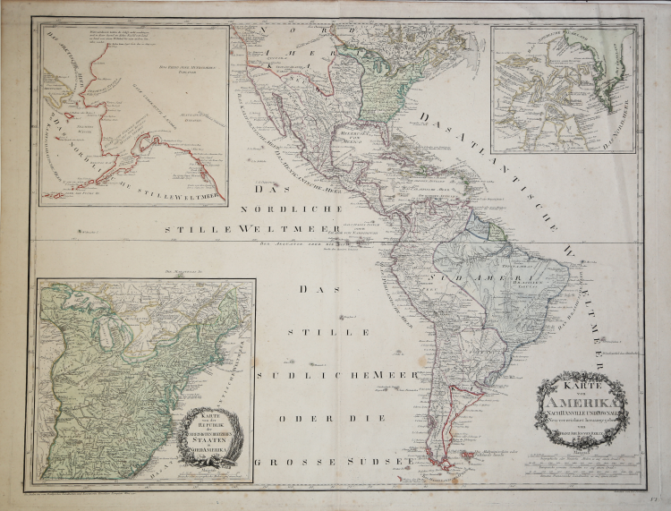
From the first world atlas to be produced by an Austrian, the "Grosse Deutscher Atlas", this is an attractive and delicately engraved map of the Americas. Included are three inset plans showing the thirteen United States of America; Alaska and the Cook Strait; and, Hudson's Bay and Greenland.
The whole is well detailed with colour used to define territories. The title cartouche appears in a floral surround at lower right and the engraver's name is also given in the lower left corner.
In North American Reilly displays the young United States in Green extending from the Atlantic Seaboard to the Mississippi river exclusive of Florida. Spanish Dominions at this time extended from Florida to the Pacific and included former French Louisiana (demarked as the area between the Mississippi River and the Sabine River). In South American the Spanish dominated the entire Pacific seaboard with Portuguese Brazil in Blue. Dutch and French colonies in Surinam and and French Guyana are noted.
The three insets, being quite large and detailed, bear special note. The largest of the three insets details the United States. This map, extending from the Atlantic to the Mississippi River is copiously detailed with fascinating annotations in German describing to American Indian lands and Revolutionary War events. This is the only of the three inset maps to have its own decorative cartouche.
A large map of Alaska appears in the upper right. The Bering Strait is detailed as are some of the Aleutian Islands. Being largely unknown at this time, it is unusual to find such a large inset map detailing such a relative unexplored region. The interior of Alaska is blank, but the coast reflects explorations by Cook (1778), Captain George Dixon (1787), and an unidentified Spanish expedition (probably Juan Perez, 1773).
The third inset map detailed the region between the Hudson Bay and Greenland The map offers impressive detail and extensive annotation regarding possible inland waterways leading westward. General interest in the possibility of a Northwest Passage is probably the reasoning behind both this map and that of Alaska on the opposite side of the map.
An attractive large format map by a relatively uncommon mapmaker.
Franz Johann von REILLY (Vienna 1766 - 1820)
|
He was a Viennese art dealer who in his early twenties turned to map publishing, and between the years 1789 and 1806 produced a total of no less than 830 maps. His Schauplatz…der Welt (World Atlas) in fact covered only maps of Europe, whilst the Grosser Deutscher Atlas also included maps of other continents and was, therefore, the first World Atlas produced by an Austrian.
1789-1806 Schauplatz der funf Theile der Welt
1794-96 Grosser Deutscher Atlas
|