
| Reference: | mms1611 |
| Author | Jean Baptiste Louis L'Abbe CLOUET |
| Year: | 1765 ca. |
| Zone: | The World |
| Printed: | Paris |
| Measures: | 680 x 450 mm |
| Reference: | mms1611 |
| Author | Jean Baptiste Louis L'Abbe CLOUET |
| Year: | 1765 ca. |
| Zone: | The World |
| Printed: | Paris |
| Measures: | 680 x 450 mm |
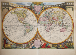
First state of this uncommon World map with the major 18th century explorers.
Rare separately published double hemisphere map of the world, issued by Clouet in Paris.
The map is largerly known for his second and common issue by Louis Joseph Mondhare (1787) showing the discovery of Hawaii (Ile Sandwich ou Why, as named on the map) and explorations in the Northwest Coast of America are quite prominent, and the major 18th century explorers like Cook (1773,1775, 1776, 1777, 1778).
Jean Baptiste Louis Clouet (born 1730) was a member of the Academie Royale des Sciences de Rouen and the author of Geographie Moderne (1767).
Etching with full contemporary colour, very good conditions.
Jean Baptiste Louis L'Abbe CLOUET (Attivo intorno al 1760)
|
Abbé Clouet was a prominent member of the Académie Royale des Sciences de Rouen. He started publishing maps in collaboration with Mondhare in Paris in the 1760's initially with geographical atlasses such as the Géographe moderne. From 1776 to the mid-1790s, much of their output was devoted to large wallmaps of the world and continents which were published as sets, and issued in 1776, 1782, 1785 and 1788. A world wallmap appeared in 1785.
|