| Reference: | S46170 |
| Author | Ambroise TARDIEU |
| Year: | 1821 |
| Zone: | The World |
| Printed: | Paris |
| Measures: | 580 x 440 mm |
| Reference: | S46170 |
| Author | Ambroise TARDIEU |
| Year: | 1821 |
| Zone: | The World |
| Printed: | Paris |
| Measures: | 580 x 440 mm |
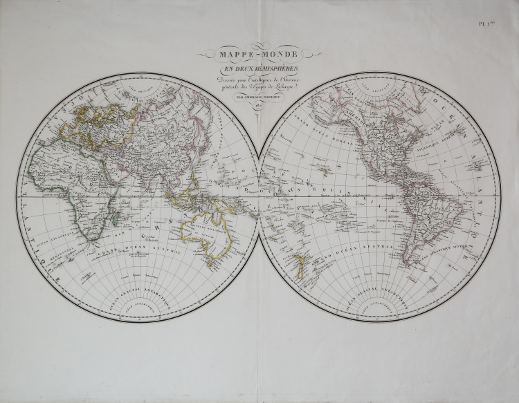
World map in two hemispheres drawn by Ambroise Tardieu for the Atlas pour servir à l'intelligence de l'histoire générale des voyages de Laharpe. The map gives an accurate and up-to-date picture of the established geographical knowledge of the first decades of the nineteenth century when it remained to be understood and questions were raised about the possibility of the Northwest Passage (left hanging here), people wanted to know about Black Africa with its mysteries about the Nile and Congo, and nothing could be known about the South Pole.
Ambroise Tardieu (1788-1841) was an important French cartographer and engraver. Taught by his uncle Pierre, also an engraver, he specialized in engraving portraits and maps. He produced more than 800 portraits, many of them of scientists, and published several atlases, including Atlas universel de geographie, ancienne et moderne/dresse par Ambroise Tardieu pour l'intelligence de la Geographie universelle par Malte-Brun.
Etching, contemporary colour of the outlines, in very good condition.
Ambroise TARDIEU (Parigi 1788 - 1841)
|
Ambroise Tardieu is a member of the great family of publishers and cartographers and engravers of maps, especially in the progenitor who had Nicolas Henri (1674-1749) and was active for about two centuries.
|
Ambroise TARDIEU (Parigi 1788 - 1841)
|
Ambroise Tardieu is a member of the great family of publishers and cartographers and engravers of maps, especially in the progenitor who had Nicolas Henri (1674-1749) and was active for about two centuries.
|