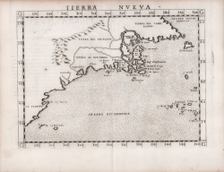
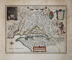
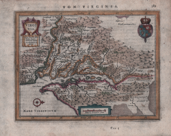
Nova Virginiae Tabula
Willem Janszoon BLAEU
Code:
S37038
Measures:
480 x 378 mm
Year:
1629 ca.
Printed:
Amsterdam
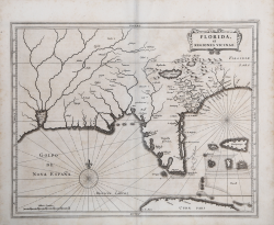
Florida et Regiones Vicinae
Johannes de Laet
Code:
S44859
Measures:
360 x 285 mm
Year:
1630 ca.
Printed:
Amsterdam
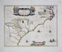
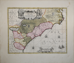
Virginiae partis australis, et Floridae partis orientalis,...
Johannes JANSSONIUS
Code:
S39702
Measures:
510 x 390 mm
Year:
1639 ca.
Printed:
Amsterdam
Virginiae partis australis et Floridae….
Johannes JANSSONIUS
Code:
ms5027
Measures:
500 x 380 mm
Year:
1639 ca.
Printed:
Amsterdam
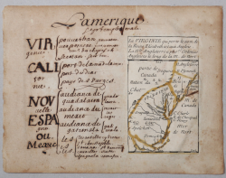
L'Amerique Septemptrionale / La Virginie
Pierre DUVAL
Code:
S35995.4
Measures:
190 x 145 mm
Year:
1656 ca.
Printed:
Paris
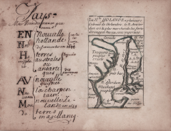
La N.le Holande a plusieurs Colonies de Holandois, le N. Amsterdam...
Pierre DUVAL
Code:
S35995.3
Measures:
190 x 145 mm
Year:
1656 ca.
Printed:
Paris
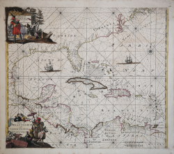
Indiarum Occidentalium Tractus Littorales cum Insulis Caribicis -...
Frederick de WIT
Code:
S37764
Measures:
572 x 490 mm
Year:
1680 ca.
Printed:
Amsterdam
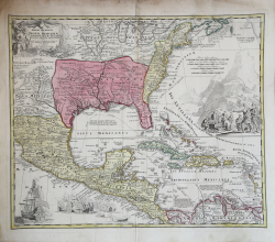
Carte du Mexique et de la Floride des Terres Angloises et des Isles...
Guillaulme DE L'ISLE
Code:
MS3818
Measures:
660 x 485 mm
Year:
1703 ca.
Printed:
Paris
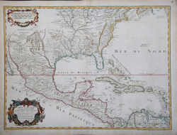
Regni Mexicani seu Novae Hispaniae Ludovicianae N. Angliae,...
Johann Baptist HOMANN
Code:
S38086
Measures:
590 x 490 mm
Year:
1716 ca.
Printed:
Nurnberg
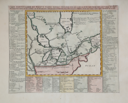
Carte Particuliere du Fleuve Saint Louis Dressee sur les Lieux Avec...
Henri Abraham CHATELAIN
Code:
S48861
Measures:
465 x 370 mm
Year:
1719
Printed:
Amsterdam
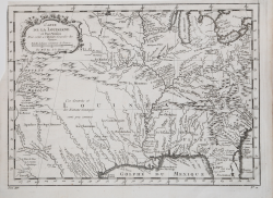
Carte de la Louisiane et Pays Voisins
Jacques Nicolas BELLIN
Code:
MS4381
Measures:
305 x 225 mm
Year:
1757 ca.
Printed:
Paris
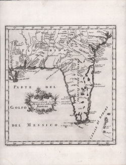
Carta Rappresentante la Penisola della Florida
Marco COLTELLINI
Code:
S49637
Measures:
315 x 230 mm
Year:
1763
Printed:
Leghorn
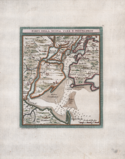
Porti di Nuova York e Perthamboy
Marco Coltellini - Gazzettiere Americano
Code:
S52505
Measures:
170 x 205 mm
Year:
1763
Printed:
Leghorn
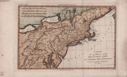
Carte de la Partie Nord des Etats Unis, de l'Amérique Septentrionale
Rigobert BONNE
Code:
S4638
Measures:
335 x 239 mm
Year:
1770 ca.
Printed:
Paris
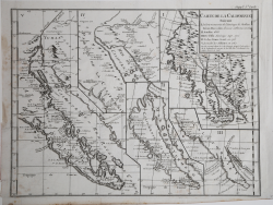
Carte De La Californie Suivant 1. La Carte manuscrite de...
Didier Robert de VAUGONDY
Code:
MS7096
Measures:
390 x 290 mm
Year:
1772 ca.
Printed:
Paris
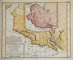
Carte de la Californie et des Pays Nord Ovest separés de l'Asie par...
Didier Robert de VAUGONDY
Code:
S4691
Measures:
375 x 315 mm
Year:
1772
Printed:
Paris
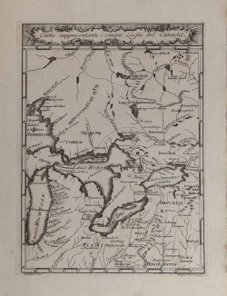
Carta rappresentante i cinque Laghi del Canada
Marco COLTELLINI
Code:
MS4776
Measures:
195 x 260 mm
Year:
1777 ca.
Printed:
Leghorn
Le Colonie Unite dell’America Settentr.le di nuova projezione...
Antonio ZATTA
Code:
MS6440
Measures:
1280 x 1300 mm
Year:
1778
Printed:
Venice