
| Reference: | S48861 |
| Author | Henri Abraham CHATELAIN |
| Year: | 1719 |
| Zone: | Saint Louis River |
| Printed: | Amsterdam |
| Measures: | 465 x 370 mm |
| Reference: | S48861 |
| Author | Henri Abraham CHATELAIN |
| Year: | 1719 |
| Zone: | Saint Louis River |
| Printed: | Amsterdam |
| Measures: | 465 x 370 mm |
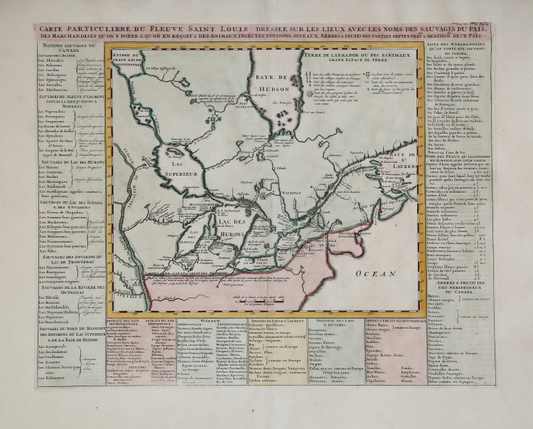
Important map of Canada, the Great Lakes and the course of the Mississippi River, extending south to the Missouri River. It is one of the best depictions of the locations of the various French missions, forts, and French and Indian settlements of the period.
The map provides one of the most interesting depictions of the Upper Mississippi at that time, drawn from Jolliet's rare map and report. In 1663 the French embarked on a policy of westward expansion, initially focusing on the location of the Mississippi River, the existence of which was known from Indian reports. Louis Jolliet, a fur trader and explorer, and Jacques Marquette, a Jesuit father, led an overland expedition westward, which departed from Green Bay in May 1673. After following the courses of the Fox and Wisconsin rivers, the expedition reached the upper Mississippi River. Continuing south, they discovered the mouths of the Missouri, Ohio, and Arkansas rivers. On the return trip, they found a shortcut to Lake Michigan by following the Illinois and Des Plaines rivers to a portage in Chicago.
Taken from Chatelain's Atlas Historique, published in Amsterdam between 1705 and 1720.
Henri Abraham Chatelain (1684 - 1743) was a Huguenot pastor of Parisian origins. He is best known as a Dutch cartographer and more specifically for his cartographic contribution in the seminal seven volume Atlas Historique, published in Amsterdam between 1705 and 1720. Innovative for its time, the Atlas Historique combined fine engraving and artwork with scholarly studies of geography, history, ethnology, heraldry, and cosmography. Some scholarship suggests that the Atlas Historique was not exclusively compiled by Henri Chatelain, as is commonly believed, but rather was a family enterprise involving Henri, his father Zacharie and his brother, also Zacharie.
Copper engraving, fine later hand colour, in excellent condition. Higly decorative.
Henri Abraham CHATELAIN (1684 - 1743)
|
Henri Abraham Chatelain (1684 - 1743) was a Huguenot pastor of Parisian origins. He is best known as a Dutch cartographer and more specifically for his cartographic contribution in the seminal seven volume Atlas Historique, published in Amsterdam between 1705 and 1720. Innovative for its time, the Atlas Historique combined fine engraving and artwork with scholarly studies of geography, history, ethnology, heraldry, and cosmography. Some scholarship suggests that the Atlas Historique was not exclusively compiled by Henri Chatelain, as is commonly believed, but rather was a family enterprise involving Henri, his father Zacharie and his brother, also Zacharie. The Atlas Historique published by Chatelain was part of a major work of its time, an encyclopaedia in seven volumes including geography as one of its main subjectes. The text was by Nicholas Gueudeville and the maps by Chatelain. The Atlas included one of the finest maps of America (4 sheets) surrounded by vignettes and decorative insets.
1705-20 Atlas Historique:Amsterdam (maps by Chatelain based on G.Delisle)
Further issues to 1739
|