
| Reference: | CO-032 |
| Author | Johannes BLAEU |
| Year: | 1662 |
| Zone: | Bracciano |
| Printed: | Amsterdam |
| Measures: | 545 x 405 mm |
| Reference: | CO-032 |
| Author | Johannes BLAEU |
| Year: | 1662 |
| Zone: | Bracciano |
| Printed: | Amsterdam |
| Measures: | 545 x 405 mm |
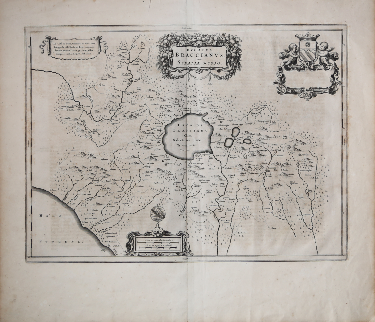
Rara carta geografica del Ducato di Bracciano di Johannes Blaeu, basata sull’importante rilievo di Giacomo Oddi (1600-16?) stampato a Roma nel 1640 circa. Opera inserita nel vol. VIII dell'Atlas Maior; uesto esemplare deriva dall’edizione con testo spagnolo al verso.
La carta del Blaeu copia fedelmente il modello; in alto a sinistra il cartiglio recita esattamente quello dell’originale. La parte in alto a destra, completamente vuota nella carta di Giacomo Oddi, viene qui riempita da un ricco cartiglio decorativo che contiene il titolo e, più a destra, da un cartiglio che doveva contenere una dedica, rimasto vuoto.
Il ducato di Bracciano è stato un feudo pontificio, situato intorno all'omonimo lago e amministrato da un ramo della famiglia Orsini con rango signorile (dal 1417) e ducale (dal 1560 al 1696).
Lo storico Campagnia, in una relazione manoscritta conservata presso l'Archivio Orsini, descrive il ducato di Bracciano come composto di "sette terre", menzionando, però, solo tre di esse: Bracciano, Anguillara e Cerveteri. Le altre quattro terre, considerando ragionevolmente l'estensione originaria del ducato (1560), erano Trevignano, Monterano, Campagnano e Formello. Completavano l'elenco altri feudi minori e tenute: Baccano, Bardella, Cantalupo, Castel Giuliano, Cesano, Galeria, Isola, Palo, Saracinesco, Scrofano, San Gregorio, Vicarello. In seguito, verranno aggiunte: Ischia, Monte Virginio, Oriolo, Rota, Viano, Rota, Baccano, Licenza, Pietraforte, Scarpa, Sorbo, Stigliano e Stracciacappe.
Acquaforte, in buono stato di conservzione.
Bibliografia
P. Frutaz, Le carte del Lazio, I, XXVII, Roma 1972, pp. 51-53. Van der Krogt 2 - 7155:2.
Johannes BLAEU (Alkmaar 1596 circa - Amsterdam 1663)
|
Joan Blaeu was the eldest son of Willem Janszoon Blaeu (1571-1638), and was probably born in Alkmaar in the province of Noord-Holland in the final years of the 16th century. He was brought up in Amsterdam, and studied law at the University of Leiden before going into partnership with his father in the 1630s. He became chief cartographer to the Dutch East India Company from 1638, and from 1651 to 1672 he served on the Amsterdam City Council without a break, holding several public offices. He also invested in Dutch colonial interests in North America. Joan Blaeu main work was Theatrum Orbis Terrarum (or Atlas Maior as it had became known.) Atlas had expanded to between 9 and 12 volumes, depending on the language. With over 3,000 text pages and approximately 600 maps, it was the most expensive book money could buy in the later 17th century. In 1638 Willem Blaeu died and the business passed into the hands of his sons, Joan and Cornelis, who continued and expanded their father's ambitious plans. After the death of Cornelis, Joan directed the work alone and the whole series of 6 volumes was eventually completed about 1655. As soon as it was finished he began the preparation of the even larger work, the Atlas Major, which reached publication in 1662 in II volumes (later editions in 9-12 volumes) and contained nearly 6oo double-page maps and 3,000 pages of text. This was, and indeed remains, the most magnificent work of its kind ever produced; perhaps its geographical content was not as up-to-date or as accurate as its author could have wished, but any deficiencies in that direction were more than compensated for by the fine engraving and colouring, the elaborate cartouches and pictorial and heraldic detail and especially the splendid calligraphy. In 1672 a disastrous fire destroyed Blaeu's printing house in the Gravenstraat and a year afterwards Joan Blaeu died. The firm's surviving stocks of plates and maps were gradually dispersed, some of the plates being bought by F. de Wit and Schenk and Valck, before final closure in about 1695.
|