| Reference: | CO-090 |
| Author | Christophe Nicolas TASSIN |
| Year: | 1634 ca. |
| Zone: | Tuscia |
| Printed: | Paris |
| Measures: | 520 x 375 mm |
| Reference: | CO-090 |
| Author | Christophe Nicolas TASSIN |
| Year: | 1634 ca. |
| Zone: | Tuscia |
| Printed: | Paris |
| Measures: | 520 x 375 mm |
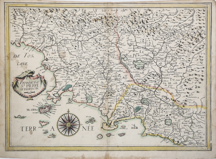
Very rare and detailed map centered on Florence and its surrounding area. Embellished with a beautiful wind-rose and a rococo title cartouche affecting the form of a sea monster.
The map is part of the composite Atlas preserved at the BNF [Rés. Ge. DD. 3479], Les cartes generales de toutes les provinces de France reveües, corrigées & augmentées par le S[ieu]r Tassin geographe ordinaire de sa magesté, Par privilege du roy 1634.
https://gallica.bnf.fr/ark:/12148/btv1b55008240v/f179.item.r=R%C3%A9s
The cartouche with the title is made by means of a small copper plate of almost oval format. This is because Tassin made this map of Tuscia using the copper from the lower right-hand pate of a large map (4 sheets) of central and northern Italy entitled Carte de la partie occidentale d'Italie. An example of the map, of the late issue by Nicola Berey, is preserved in the British Library [Cartographic Items Maps K.Top.75.72].
Christophe Tassin, also known as Nicolas Tassin, was a French cartographer, known for his atlases of France, Spain, Germany and Switzerland. Most of his work was published in Paris from 1633 to 1635. Up to 1631 Christophe Tassin was a French Royal Engineer and Geographer (Ingenieur et Geographe du Roy), working on assigned political and military projects. As part of his appointment, he received the right to publish his work for ten years, though he used it only between 1633 and 1638. In 1633 Tassin published an atlas of France and Spain, Cartes générales des provinces de France et d’ Espagne; one of Germany, Cartes généralis des royaumes et provinces de la haute et basse Allemagna; and one of the Low Countries, Plans et profils des principales villes du duché de Lorraine, avec les cartes generale et particulieres de chacun gouvernement d’iucelles. In 1634 he published his magnum opus, an atlas – in an oblong quarto format, for which he is best known – with maps, views and plans of cities and other places in France, Les plans et profils de toutes les principales villes et lieux considerables de France, as well as a coastal atlas of France, Carte générale de toutes les costes de France. Finally, in 1644, he sold all his copperware to two other tailles douces merchants. Antoine de Fer and Nicolas Berey. for the sum of 3500 livres. Christophe Tassin is best known for his small oblong atlases but also for the collection of folio maps (Pastoreau, TASSIN IIa). Tassin's maps and plans bear neither an author's nor an engraver's name. They are, however, uniform in style, with rounded lettering, grotesque cartouches and ships in the sea. These features make them instantly recognizable. Antoine de Fer and Nicolas Berey, once in possession of the copperplates, also made reprints.
Etching with original coloring, impressed on contemporary laid paper, some wax stains (probably) on left side next to cartouche, moisture halo in lower white margin, otherwise in good condition.
Work of great rarity.
Bibliografia
M. Pastoureau, Les atlas français, XVIe-XVIIe siècles: répertoire bibliographique et étude. Imprint, Paris: Bibliothèque nationale, Dép. des cartes et plans, 1984, Tassin II A, n. 53.
Christophe Nicolas TASSIN (Attivo nella prima metà del XVII sec.)
|
Christophe Tassin (born in the early 1600s in France; died in 1660 in France), also known as Nicolas Tassin, Christophe Nicolas Tassin or Christophe Le Tassin, was a French cartographer, known for his atlases of France, Spain, Germany and Switzerland. Most of his work was published in Paris from 1633 to 1635. Among his colleagues were Melchior Tavernier (1594–1665), Sébastien Cramoisy (1584–1669) and Michael van Lochum (1601–1647). Little is known of his personal life.
Up to 1631 Christophe Tassin was a French Royal Engineer and Geographer (Ingenieur et Geographe du Roy), working on assigned political and military projects. As part of his appointment, he received the right to publish his work for ten years, though he used it only between 1633 and 1638. In 1633 Tassin published an atlas of France and Spain, Cartes générales des provinces de France et d’ Espagne; one of Germany, Cartes généralis des royaumes et provinces de la haute et basse Allemagna; and one of the Low Countries, Plans et profils des principales villes du duché de Lorraine, avec les cartes generale et particulieres de chacun gouvernement d’iucelles.
In 1634 he published his magnum opus, an atlas – in an oblong quarto format, for which he is best known – with maps, views and plans of cities and other places in France, Les plans et profils de toutes les principales villes et lieux considerables de France, as well as a coastal atlas of France, Carte générale de toutes les costes de France.
In 1635 he published an atlas of Switzerland, Description de tovs les cantons, villes, bourgs, villages et av tres particularitzes du pays des Suisses. His inclusion of the Low Countries in a single volume had a practical reason: in 1631 a great part of the region had been conquered by King Louis XIII of France, which caused a need for rapidly published information. Finally, in 1644, he sold all his copperware to two other tailles douces merchants. Antoine de Fer and Nicolas Berey. for the sum of 3500 livres.
Christophe Tassin is best known for his small oblong atlases but also for the collection of folio maps (Pastoreau, TASSIN IIa). Tassin's maps and plans bear neither an author's nor an engraver's name. They are, however, uniform in style, with rounded lettering, grotesque cartouches and ships in the sea. These features make them instantly recognizable. Antoine de Fer and Nicolas Berey, once in possession of the copperplates, also made reprints.
|