
| Reference: | S40087 |
| Author | Nicolas VISSCHER I |
| Year: | 1677 ca. |
| Zone: | Danube |
| Printed: | Amsterdam |
| Measures: | 590 x 480 mm |
| Reference: | S40087 |
| Author | Nicolas VISSCHER I |
| Year: | 1677 ca. |
| Zone: | Danube |
| Printed: | Amsterdam |
| Measures: | 590 x 480 mm |
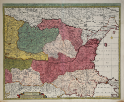
Peter Schenk edition of the Nicolas Visscher's detailed map of the lower Danube, extending from Belgrade to the Black Sea. Issued circa 1720.
The map extends to Constantinople and the Bosphorus Straits in the southeast to the Ukraine and Podolia in the northeast, and from northern Greece in the southwest to the southern part of the Kingdom of Poland in the northwest, centered on Bulgaria and Valachia.
Copperplate with fine original colouring, good condition.
Nicolas VISSCHER I (1618 - 1679)
|
For nearly a century the members of the Visscher family were important art dealers and map publishers in Amsterdam. The founder of the business, C. J. Visscher, had premises near to those of Pieter van den Keere and Jodocus Hondius whose pupil he may have been. From about 1620 he designed a number of individual maps, including one of the British Isles, but his first atlas consisted of maps printed from plates bought from van den Keere and issued as they stood with some additions of his own, including historical scenes of battles and sieges for which he had a high reputation. Some maps bear the latinized form of the family name: Piscator. After Visscher's death his son and grandson, both of the same name, issued a considerable number of atlases, constantly revised and brought up to date but most of them lacking an index and with varying contents. The widow of Nicholaes Visscher II carried on the business until it finally passed into the hands of Pieter Schenk.
|