
| Reference: | ms930 |
| Author | Frederick de WIT |
| Year: | 1675 ca. |
| Zone: | Brazil |
| Printed: | Amsterdam |
| Measures: | 575 x 490 mm |
| Reference: | ms930 |
| Author | Frederick de WIT |
| Year: | 1675 ca. |
| Zone: | Brazil |
| Printed: | Amsterdam |
| Measures: | 575 x 490 mm |
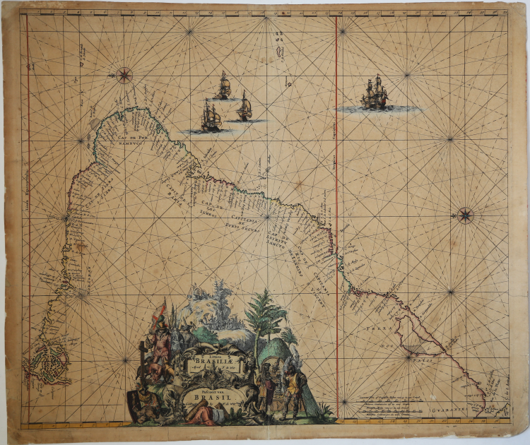
Magnificent map of Brazilian coasts, first published in the Orbis Maritimus ofte Zee Atlas and afterwards included in some composite atlases and in the Atlas de la Navigation, 1715.
Oriented with north to the left by two fine compass roses, it covers the Brazilian coastline from the mouth of the Amazon to the Rio de la Plata in what is now Argentina.
A beautiful title cartouche depicts scenes showing Portuguese and Dutch explorers and missionaries, an Indian ceremony, mining, exotic animals, and produce, etc.
The map is further embellished by four sailing ships
Copper engraving, contemporary colour, minor tears perfectly repaired, otherwise in good condition.
Original De Wit’s edition, published around 1675.
|
Shirley (BL Atlases) M.REN-1a.
|
Frederick de WIT (1630 - 1706)
|
De Wit was one of the most prominent and successful map engravers and publishers in Amsterdam in the period following the decline of the Blaeu and Jansson establishments, from which he acquired many copper plates when they were dispersed at auction. His output covered most aspects of map making: sea charts, world atlases, an atlas of the Netherlands, 'town books' covering plans of towns and cities in the Netherlands and Europe, and wall maps. His work, notable for the beauty of the engraving and colouring, was very popular and editions were issued many years after his death by Pieter Mortier and Covens and Mortier.
|
|
Shirley (BL Atlases) M.REN-1a.
|
Frederick de WIT (1630 - 1706)
|
De Wit was one of the most prominent and successful map engravers and publishers in Amsterdam in the period following the decline of the Blaeu and Jansson establishments, from which he acquired many copper plates when they were dispersed at auction. His output covered most aspects of map making: sea charts, world atlases, an atlas of the Netherlands, 'town books' covering plans of towns and cities in the Netherlands and Europe, and wall maps. His work, notable for the beauty of the engraving and colouring, was very popular and editions were issued many years after his death by Pieter Mortier and Covens and Mortier.
|