| Reference: | S41722.126 |
| Author | Attilio ZUCCAGNI ORLANDINI |
| Year: | 1844 |
| Zone: | Sicilia |
| Printed: | Florence |
| Measures: | 745 x 600 mm |
| Reference: | S41722.126 |
| Author | Attilio ZUCCAGNI ORLANDINI |
| Year: | 1844 |
| Zone: | Sicilia |
| Printed: | Florence |
| Measures: | 745 x 600 mm |
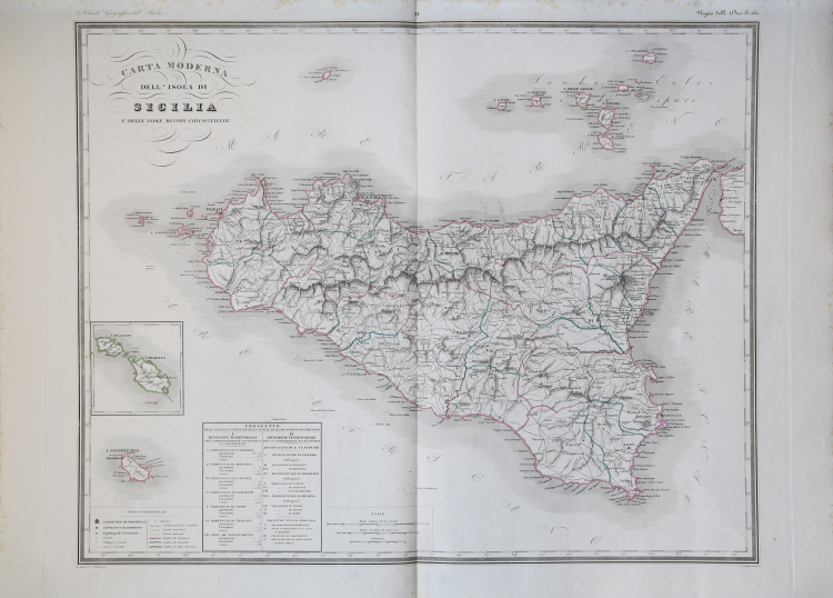
Map taken from the Atlante geografico degli Stati italiani delineato sopra le migliori e più moderne mappe per servire di corredo alla corografia fisica storica e statistica dell'Italia, di Attilio Zuccagni Orlandini printed in Florence, 1844. The first volume contains the maps of Northern Italy in 52 sheets, the second volume those of Southern Italy in 77 sheets.
Attilio Zuccagni Orlandini (1784-1872) was born in Fiesole under the name of Giuseppe Orlandini. Following adoption by his wealthy maternal uncle Attilio Zuccagni (1754-1807), a botanist and georgofile, he took the name Attilio Zuccagni Orlandini.
His most important work is the geographic-cartographic report of all the pre-unification Italian states, the great Corografia fisica, storica e statistica dell'Italia e delle sue Isole (Florence 1835-1845), in twelve volumes for nineteen tomes, with an introductory volume on the entire Italian peninsula. The work constituted the sum of hundreds of general, regional and local geographic works then available and presented, for each pre-unification state, the physical, historical, topographical and statistical framework. In 1844-45, the Corografia was enriched with five volumes of maps, views and other illustrations of places and monuments: Atlante geografico degli Stati italiani delineato sopra le migliori e più moderne mappe (two volumes with 144 plates including the large map of the peninsula in 15 sheets) and Atlante illustrativo ossia raccolta dei principali monumenti italiani antichi, del medio evo e moderni e di alcune vedute pittoriche (three volumes with 413 illustrations, printed on 269 sheets). The plates were engraved, again in Florence, in two special workshops, by four talented Lombard artists (Vittorio Angeli, Giacinto Maina, Pietro Manzoni and Giuseppe Pozzi).
Especially the first of the two atlases represents, even today, a milestone in the history of cartography and Italian geographic iconography. It was truly 'an arduous undertaking', since cartographic products were often still lacking (as, for example, for the Duchy of Lucca and the Papal States) fully geometric. The two products were presented to the Georgofili in 1843 and 1844, along with the map of the Republic of San Marino. The work proved to be very expensive and did not achieve the commercial success hoped for, but served as a basis for many other subsequent publishing initiatives that drew on it, sometimes without even respecting the copyright.
“La carta fa parte del primo e più importante atlante generale dell'Italia pubblicato nel corso dell'800. L'atlante, in due volumi, fa parte di una più complessa opera sull'Italia, composta di 17 volumi monografici dedicati ai singoli stati e alle principali aree geografiche che la componevano e di tre volumi di vedute. Si tratta di un vero e proprio monumento geografico, iconografico e stati- stico alla nazione prima della sua Unità, certamente intriso di spirito risorgimentale.
In un piccolo riquadro (93x94) è rappresentato il gruppo maltese. Nell'angolo in basso a sinistra trovano posto i "Segni convenzionali" e un "Prospetto" con la divisione amministrativa ed ecclesiastica dell'isola. La carta è chiaramente ripresa da quella dell'Officio Topografico di Napoli del 1826. Questa carta verrà rimessa in circolazione, insieme a gran parte delle carte dell'Atlante geografico degli stati italiani, da Francesco Vallardi all'indomani dell'Unità. Le uniche modifiche che si riscontrano rispetto ai rami originari sono le aggiunte dei dati editoriali di Vallardi. In questa carta, sotto il titolo, è impressa la scritta "Milano Dott. Francesco Vallardi, tipografo-editore".” (Valerio-Spagnolo "Sicilia 1477-1861", p. 674).
Copperplate with fine outline colour, good condition.
Bibliografia:
Valerio-Spagnolo "Sicilia 1477-1861", pp. 671-675, n. 356; Anna Guarducci - Dizionario Biografico degli Italiani - Volume 100 (2020).
Attilio ZUCCAGNI ORLANDINI (Fiesole 1784 - Firenze 1872)
|
Attilio Zuccagni Orlandini (Fiesole 1784-Firenze 1872), who realized the great Atlante Geografico Fisico e Storico of Tuscany, consisting of 20 big plates with explicatory text and published between 1828 and 1832, prolonged to the whole Italian peninsula a graphic and descriptive illustration, published in 1845, consisting of 19 books and a big atlas in 5 in folio volumes, called "Corografia Fisica, Storica e Statistica dell'Italia e delle sue Isole" supplied with the "Atlante illustrativo ossia Raccolta dei principali monumenti italiani antichi, del Medio Evo e moderni e di alcune vedute pittoriche per servire di corredo alla corografia fisica storica e statistica dell’Italia di Attilio Zuccagni-Orlandini". The work has been published in Florence by the Società Editrice between 1842-45. Giacinto Maina, Valerio Stanghi, Antonio Verico and others engraved the plates.
|