
| Reference: | S32415 |
| Author | Antonio ZATTA |
| Year: | 1791 ca. |
| Zone: | New Zealand |
| Printed: | Venice |
| Measures: | 355 x 450 mm |
| Reference: | S32415 |
| Author | Antonio ZATTA |
| Year: | 1791 ca. |
| Zone: | New Zealand |
| Printed: | Venice |
| Measures: | 355 x 450 mm |
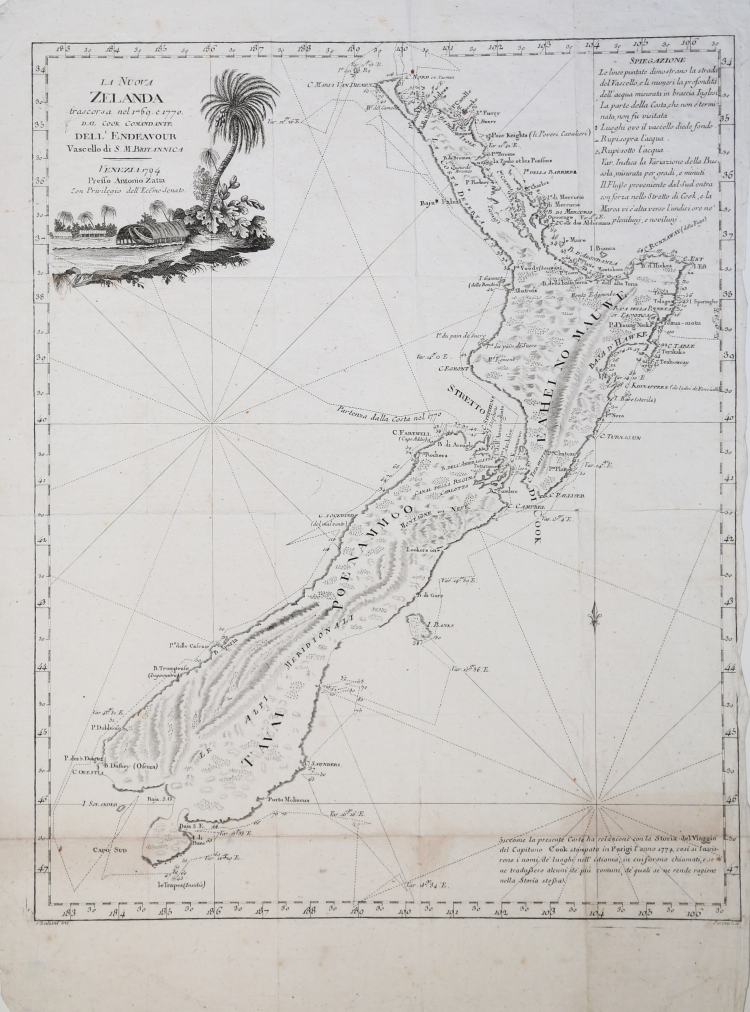
- THE VERY RARE SECOND EDITION OF 1794 -
Taken from 'Raccolta di tutti i viaggi fatti intorno al mondo da diverse nazioni dell’Europa' by Jean Pierre Berenger. The date is changed into 1794
Antonio Zatta's map of New Zealand is not only one of the first to show the results of Cook's voyages, but is also one of the most attractive of the islands. Considerable coastal detail, with reference to the Endeavour's path, and a little and surmised internal detail.
The map delineates two islands, tentatively identifying the Southern Island separate. The map shows Cook's tracks around the island, along with the astronomical observations. Nice topographical detail is shown, along with a blend of native and European place names on the islands. The map includes several annotations. The decorative cartouche, in full original colour, shows a native village scene.
New Zealand, though discovered by Tasman in 1642, received no further European exploration until the first Pacific voyage of James Cook. Cook sailed the coast of New Zealand for 6 months, proving that it was not part of the Great Southern Continent, as many had believed. Cook visited New Zealand several times, with Zatta's map drawn from information provided in the latest of his voyages.
Antonio ZATTA (Venezia 1722 - 1804)
|
Antonio Zatta (1775-1797) was the most prominent Italian map publisher of the late 18th and early 19th century. His firm, based in Venice, produced maps that mark an important transition from 18th to 19th century cartographic styles. He updates and redefines the traditional title cartouche by replacing the mythic elements common to the 17th and 18th century with more representative images of Venice. His most important work is the four volume Atlante novissimo published from 1775 to 1789.
|