
- New
| Reference: | s30236 |
| Author | James COOK |
| Year: | 1774 |
| Zone: | New Zeland |
| Printed: | Paris |
| Measures: | 404 x 510 mm |
| Reference: | s30236 |
| Author | James COOK |
| Year: | 1774 |
| Zone: | New Zeland |
| Printed: | Paris |
| Measures: | 404 x 510 mm |
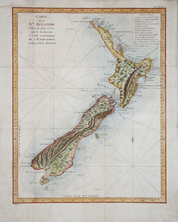
First French edition of the most important map in the history of New Zealand, the first complete map of the coasts of the two islands.
The original survey for the map was carried out between 1769 and 1770, during Cook's first voyage, and shows the course of HMS Endeavour, with dates and depths, while the interior reflects the mountainous topography seen from the ship and the coast. This French version of the map is a translation of the English map published with the first edition of James Hawkesworth's collection of travels: An Account of the Voyages Undertaken by the Order of his Present Majesty for Making Discoveries in the Southern Hemisphere, and Subsequently Performed by Commodore Byron, Captain Wallis, Captain Carteret, and Captain Cook, in the Dolphin, the Swallow, and the Endeavour: Drawn from the Journals Kept by the Several Commanders, and from the Papers of Joseph Banks, Esq., which was printed in 1773 and published in Paris in 1774.
Captain James Cook (1728–1779) is considered the greatest explorer and the most excellent maritime cartographer of the 18th century. After distinguishing himself as a surveyor in eastern Canada, in 1768 he was chosen by the British Admiralty to lead an unprecedented voyage of discovery. The expedition's primary objective was to observe the transit of Venus from Tahiti and then proceed to explore Terra Australis Incognita, the reputedly rich southern continent. Cook's expedition set sail from Plymouth in August 1768 aboard HMS Endeavour and headed for Tahiti via Cape Horn. They arrived in time to observe the transit of Venus, which occurred on June 3, 1769. Cook then continued on to New Zealand, at the coordinates previously recorded by Abel Tasman (1609–1653). On October 6, 1769, Endeavour sighted the North Island (Te Ika a Maui) at Turanga Nui, which Cook renamed Poverty Bay. He and his crew had landed on the opposite coast from where Tasman had encountered the island. Cook continued on to the South Island (Te Wai Pounamu), carefully mapping both landmasses with a continuous survey. He used soundings, visual observations, and triangulation, guided by astronomical observations, to create his manuscript nautical charts.
Etching, finely hand-colored, very good condition.
|
Captain James Cook (7 November 1728 - 14 February 1779) is a seminal figure in the history of cartography for which we can offer only a cursory treatment here. Cook began sailing as a teenager in the British Merchant Navy before joining the Royal Navy in 1755. He was posted in America for a time where he worked Samuel Holland, William Bligh, and others in the mapping of the St. Lawrence River and Newfoundland. In 1766 Cook was commissioned to explore the Pacific and given a Captaincy with command of the Endeavour. What followed were three historic voyages of discovery, the highlights of which include the first European contact with eastern Australia, the discovery of the Hawaiian Islands (among many other Polynesian groups), the first circumnavigation of New Zealand, some of the first sightings of Antarctica, the first accurate mapping of the Pacific Northwest, and ultimately his own untimely death at the hands of angry Hawaiians in 1779.
|
|
Captain James Cook (7 November 1728 - 14 February 1779) is a seminal figure in the history of cartography for which we can offer only a cursory treatment here. Cook began sailing as a teenager in the British Merchant Navy before joining the Royal Navy in 1755. He was posted in America for a time where he worked Samuel Holland, William Bligh, and others in the mapping of the St. Lawrence River and Newfoundland. In 1766 Cook was commissioned to explore the Pacific and given a Captaincy with command of the Endeavour. What followed were three historic voyages of discovery, the highlights of which include the first European contact with eastern Australia, the discovery of the Hawaiian Islands (among many other Polynesian groups), the first circumnavigation of New Zealand, some of the first sightings of Antarctica, the first accurate mapping of the Pacific Northwest, and ultimately his own untimely death at the hands of angry Hawaiians in 1779.
|