
| Reference: | S45976 |
| Author | Pierre Marie LAPIE |
| Year: | 1817 |
| Zone: | Oceania, Pacific Ocean |
| Printed: | Paris |
| Measures: | 790 x 540 mm |
| Reference: | S45976 |
| Author | Pierre Marie LAPIE |
| Year: | 1817 |
| Zone: | Oceania, Pacific Ocean |
| Printed: | Paris |
| Measures: | 790 x 540 mm |
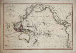
Rare large chart of the Pacific Ocean by Pierre Marie Lapie, published in 1817.
At the top left: Oceanie ou Australasie et Polynesie / par Lapie; gravee par Blondeau graveur du Roi et premier graveur du Depot de la Guerre a Paris: Chez Basset Md. d'Estampes rue St. Jacques no. 64, 1817
Shows the world during the Age of Exploration, tracing the ambitious voyages of explorers like Magellan, Cook and Vancouver.
Lapie, as geographer to the King Louis XVIII, presents work that is both precise and artistic, with topographical features, sea-routes and political boundaries articulated with clarity and subtle coloration. Meticulous calligraphy, especially in the title and legends, showcases the stylistic preferences of early 19th-century France. Routes include the voyages of: Magellan 1521; Bering 1741; Anson 1743; Byron 1765; Bougainville 1769; Cook, 1773, 1769, 1777, 1778; Furneau, 1773; Clerke 1780; La Perouse 1786; Marchang 1791; La Recherche 1792, 1795; Vancouver 1791, 1793, 1794; Flinders 1803; Krusenstern, 1804, 1805.
Pierre M. Lapie (fl. 1779 - 1850) and his son Alexandre Emile Lapie (fl. 1809 - 1850) were French cartographers and engravers active in the early part of the 19th century. The Lapies were commissioned officers in the French army holding the ranks of Colonel and Capitan, respectively. Alexander enjoyed the title of "First Geographer to the King", and this title appears on several of his atlases. Both father and son were exceptional engravers and fastidious cartographers. Working separately and jointly they published four important atlases, an 1811 Atlas of the French Empire (Alexander), the 1812 Atlas Classique et Universel (Pierre), the Atlas Universel de Geographie Ancienne et Modern (joint issue), and the 1848 Atlas Militaire (Alexander). They also issued many smaller maps and independent issues.
Etching with fine original hand colour, good condition.
Pierre Marie LAPIE (1779-1850)
|
Pierre M. Lapie (fl. 1779 - 1850) and his son Alexandre Emile Lapie (fl. 1809 - 1850) were French cartographers and engravers active in the early part of the 19th century. The Lapies were commissioned officers in the French army holding the ranks of Colonel and Capitan, respectively. Alexander enjoyed the title of "First Geographer to the King", and this title appears on several of his atlases. Both father and son were exceptional engravers and fastidious cartographers. Working separately and jointly they published four important atlases, an 1811 Atlas of the French Empire (Alexander), the 1812 Atlas Classique et Universel (Pierre), the Atlas Universel de Geographie Ancienne et Modern (joint issue), and the 1848 Atlas Militaire (Alexander). They also issued many smaller maps and independent issues.
|