| Reference: | S38004 |
| Author | Ippolito Scalza |
| Year: | 1583 |
| Zone: | Orvieto |
| Printed: | Rome |
| Measures: | 525 x 440 mm |
| Reference: | S38004 |
| Author | Ippolito Scalza |
| Year: | 1583 |
| Zone: | Orvieto |
| Printed: | Rome |
| Measures: | 525 x 440 mm |
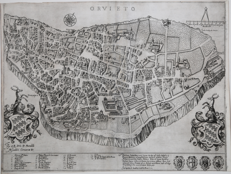
Magnificent example of the very rare first state (of four) of the first printed map of Orvieto, engraved by Giovan Battista de Cavalleris based on a drawing by Ippolito Scalza. Beautiful example, in perfect condition.
At the top center, under the upper edge, the title: ORVIETO. On the sides of the plate are the heraldic coats of arms of the Monaldeschi family; under the left one the dedication: Ill. et R. D[omi]no. D. Monaldo Monalden. Cervariae D. Along the lower edge is engraved a numerical legend of 27 key-references to notable places and monuments. A table follows with distances of the city from surrounding places: Urbsvetus Italiae Etruscoru[m] Civitas Distat ab Urbe Milia 60. à Perusio Milia 30. à Lacu Vulsinio Milia .6. à Tiberi fluvio Milia.3. in ambitu habet Milia .3. Sita est supra lapidem Tufium supra Collem existenteni Ovispetiem referens. Hunc locu[m] primum coluerunt Aramei ab eis Arbanum appellatum inde a Pelagis Oropitum, postea vero à Latinis Urbivetus. Follows the printing details: Ioa. Baptista de Cavallerijs incidebat Romae 1583.
In basso a destra sono incisi altri quattro stemmi, probabilmente relativi sempre alla famiglia Monaldeschi.
Orientazione fornita da una rosa dei venti, il nord–ovest è in alto. Nell’angolo superiore sinistro, evidenziata da un compasso, la scala grafica Canne di piedi, et ogni cinque piedi sono otto palmi Romaneschi (100 canne = mm 88).
This is the first printed topographic representation of the city of Orvieto. Designed by the Orvieto architect and sculptor Ippolito Scalza, who dedicated it to Monaldo Monaldeschi, descendant of the ancient noble Orvieto Monaldeschi family, protagonist, together with the rival Filippeschi, of the medieval events of the city, so much so that they were cited in Canto VI of Dante's Purgatory. Monaldo was the author of the Comentari Historici of the city, which were published in 1584. Scalza, in possession of the technical-scientific skills to carry out the topographical survey, was often employed by the Monaldeschi for their artistic commissions. As Monaldo himself testifies, the survey of the city dates back to the time of Pope Pius IV (died in 1565), while the engraving, which derives from Scalza's drawings, only came to light in 1583 for the presses of Giovan Battista de Cavalleris. The city is presented on a stone support, without any reference to the surrounding landscape. The drawing is rotated so as to present the Cathedral as the center of the city, exactly equidistant from the two Monaldeschi coats of arms. Scalza's plan, republished in 1620 by Angiola Marcucci, later served as a model for Luca Holstenius to represent the map of Orvieto in the Gallery of Geographical Maps in the Vatican.
Ippolito Scalza (Orvieto, 1532 – 1617) was an Italian sculptor and architect, coming from a family active in the artistic field; his two brothers were also architects, sculptors and mosaicists. The first real news of him dates back to 1554, when he was found assisting Simone Mosca and Raffaello da Montelupo, during the works for the Cathedral of Orvieto. As a sculptor he composed the Farrattini tomb in Amelia in 1564. In 1567 he was promoted to master builder of the Cathedral of Orvieto; a position he held until his death, taking care of the decorations for the side chapels, giving life to the Pietà group. He also designed the Cathedral of Montepulciano, the church of the Crucifix in Todi and the Parish Church of Ficulle.
Etching, printed on contemporary laid paper, in perfect condition. Example of the first state of four described in Bifolco/Ronca; the map was reprinted by Angiola Marcucci, Giacomo Marcucci and Giovanni Battista de Rossi.
Extremely rare map in all its editions. The first state of the Orvieto map is known for only 3 institutional copies: Atlante Stevens-Beans-Nebenzahl; Malta, National Library; Salisburgo, Universitatsbibliothek.
Bibliografia
Bifolco-Ronca, Cartografia e Topografia Italiana del XVI secolo, p. 2266, tav. 1163 I/IV; Bonasera (1979): p. 88, n. 21; Destombes (1970): n. 83; Ganado (1994): VI, n. 108 & p. 213, n. 60; Shirley (2004): III, n. 45. Benevolo (1969): pp. 82-84, tav. XVI; Brasini (1988); Fumi (1928): p. 5; Nagler (1858-79): n. 964; Satolli (2017): pp. 100-101, scheda XXX; Tooley (1939): n. 425.
Ippolito Scalza(Orvieto, 1532 – 1617)
Ippolito Scalza(Orvieto, 1532 – 1617)