| Reference: | S49238.33 |
| Author | Marcus JORDAN |
| Year: | 1588 ca. |
| Zone: | Denmark |
| Printed: | Antwerpen & Cologne |
| Measures: | 460 x 385 mm |
| Reference: | S49238.33 |
| Author | Marcus JORDAN |
| Year: | 1588 ca. |
| Zone: | Denmark |
| Printed: | Antwerpen & Cologne |
| Measures: | 460 x 385 mm |
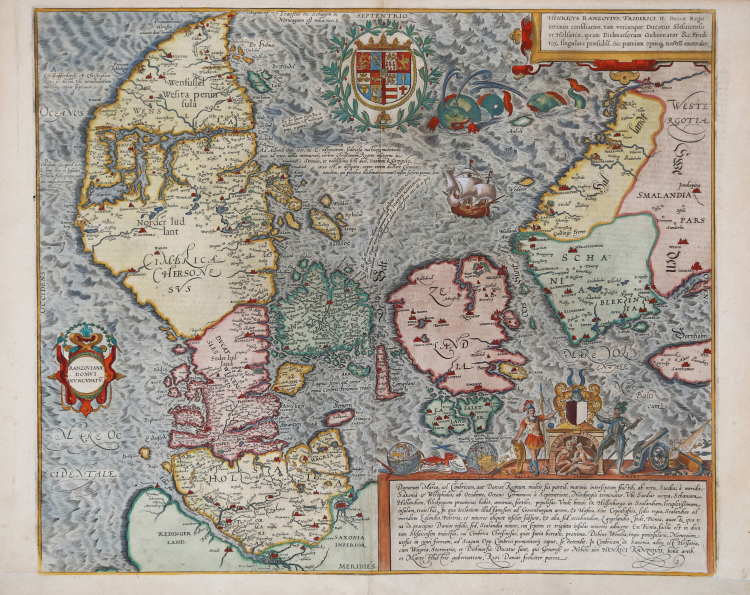
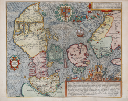
The oldest preserved map of Denmark of Danish origin
Towards the middle of the sixteenth century, what one might call an embryonic school of cartography was formed in Denmark. Since 1550, Marcus Jordan (1521-1595) had been teaching mathematics and geography at the University of Copenhagen. His reputation as a cartographer had spread beyond the frontiers of his country and his work was highly praised by such map publishers as Abraham Ortelius and Gerard Mercator.
Even more celebrated was his compatriot Tycho Brahe (1546- 1601), even though he had published only one small map of the island of Ven. In the 1580s Brahe had the intention of mapping the whole of Denmark. With this end in view, assisted by his pupils, he fixed the degree of latitude of many locations. But the bad relationship between King Frederic II and Brahe ruined the undertaking. It was mostly his qualities as a teacher that made Brahe well known. Among his pupils was the Dutchman Willem Jansz Blaeu. It was thus through the mediation of Jordan and Brahe that good relations were established between the Danes and the most distinguished Dutch cartographers of the period. The Danes sought to turn this to their advantage in their frontier disputes over Finnmark on the Arctic Ocean coasts.
The map of Denmark was however drawn by Marcus Jordan at the request of Duke Heinrich Graf von Rantzau (1526-98), viceroy of Schleswig-Holstein. It is a new perception of Denmark founded on Jordan's own measurements and observations. It became an important source for the great contemporary Dutch cartographers (Ortelius and Mercator).
Showing Denmark with Holstein and Zealand with Bornholm in the east. Decorated with three cartouches, the coat of arms of Denmark, two whales and a sailing boat. The small cartouche in upper right corner has a dedication to Rantzau. This is the second state from 1588 without the year in the lower title cartouche.
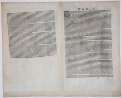
Jordan's map is the only real map in Braun & Hogenberg's famous work "Civitates Orbis Terrarum", which has numerous views of the most important towns in Europe. The map appeared in Vol IV in 1588. On the verso a detailed Latin description of the various provinces of Dania.
Heinrich Graf von Rantzau was an important contributor of plans for the 'Civitates': perhaps Braun & Hogenberg included this map in order not to offend him. Above this cartouche is Rantzau himself, as Mars the god of war, with his foot on the imprisoned Skipper Clemens a famous Danish rebel farmer. The figure of Pallas Athene symbolizes the Duke's well known humanistic interests.
Etching with fine later hand colour, perfect condition.
Bibliografia
Dreyer-E., Geschichte, p. 102: Bramsen, pp. 58-61. Ginsberg p. 105, 24.9; Van der Krogt 4 – 4986 II/II.
|
Since 1550, Marcus Jordan (1521-1595) had been teaching mathematics and geography at the University of Copenhagen. His reputation as a cartographer had spread beyond the frontiers of his country and his work was highly praised by such map publishers as Abraham Ortelius and Gerard Mercator.
|
|
Since 1550, Marcus Jordan (1521-1595) had been teaching mathematics and geography at the University of Copenhagen. His reputation as a cartographer had spread beyond the frontiers of his country and his work was highly praised by such map publishers as Abraham Ortelius and Gerard Mercator.
|