| Reference: | S10727 |
| Author | Johannes JANSSONIUS |
| Year: | 1652 ca. |
| Zone: | Tunis |
| Printed: | Amsterdam |
| Measures: | 420 x 325 mm |
| Reference: | S10727 |
| Author | Johannes JANSSONIUS |
| Year: | 1652 ca. |
| Zone: | Tunis |
| Printed: | Amsterdam |
| Measures: | 420 x 325 mm |
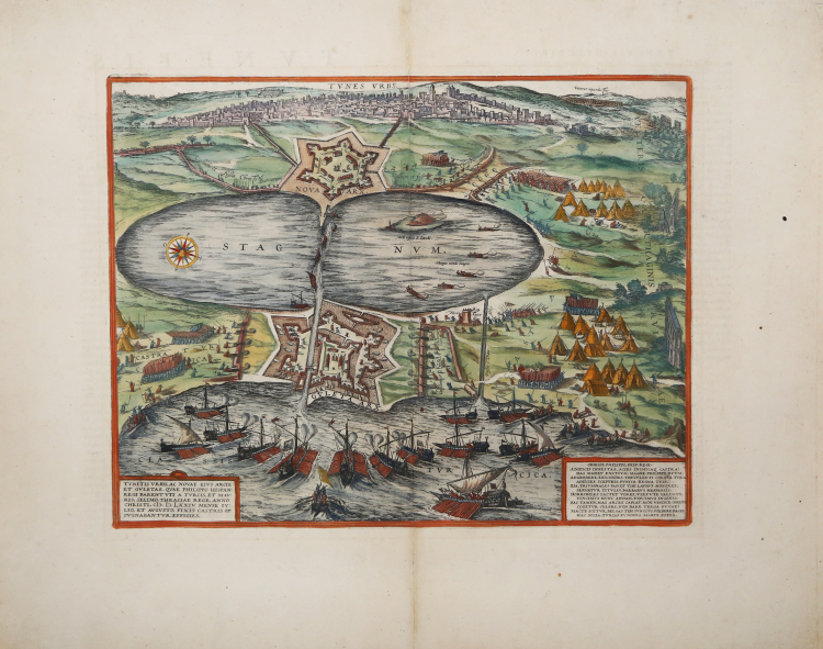
This image of Tunis shows the town under siege: the city is seen from the east, as well as the Gulf of Tunis, and the large stagnant lagoon (stagnum), today called El Bahira, in front of it. At both entrances to the sea the fortresses La Goulette and Nova Arx are found; the town is seen in the background. After an Italian broadsheet published in Rome by Antonio Lafreri in 1573.
Tunis, which was founded before the 9th century BC, was always an apple of discord due to its location. Following multiple Arabic and African rulers the Europeans attempted to capture the town for the first time in 1270. Yet it wasn't until 1535 that this could be accomplished, by Charles V, who with it achieved an important victory over the Ottoman Empire; he was even able to defeat the Turk's most formidable leader, Khair ad-Din, otherwise known as Barbarossa. In 1569 the Turks captured Tunis under Kilic Ali Pasha, then lost it in 1573 to Philip II of Spain and won it back in 1574.
The work is first included in the Civitates Orbis Terrarum, the first atlas devoted exclusively to plans and views of the world's major cities.
This map is taken from the "Theatrum praecipuarum urbium" a townbook by Johannes Janssonius, in the style of Braun & Hogenberg's "Civitates Orbis Terrarum." The collection, published in Amsterdam between 1652 and 1657, contains 500 plates depicting cities from all parts of the world.
In contrast to the work of the competitor Johannes Blaeu, Janssonius made use of plates from previous cartographers and publishers for the work. In 1653 he purchased the plates of "Civitates orbis Terrarum" from Abraham Hogenberg, which he incorporated into his work, reprinting them, with some changes.
Copperplate, printed on contemporary laid paper, fine later hand colour, in very good condition.
|
Van der Krogt 4, 4517; Fauser, 14325; Taschen, Braun and Hogenberg, p.198.
|
Johannes JANSSONIUS (1588-1664)
|
Johannes Janssonius, more commonly known to us as Jan Jansson, was born in Arnhem where his father was a bookseller and publisher (Jan Janszoon the Elder). In 1612 he married the daughter of the cartographer and publisher Jodocus Hondius, and then set up in business in Amsterdam as a book publisher. In 1616 he published his first maps of France and Italy and from then onwards he produced a very large number of maps, perhaps not quite rivalling those of the Blaeu family but running a very close second in quantity and quality. From about 1630 to 1638 he was in partnership with his brother-in-law, Henricus Hondius, issuing further editions of the Mercator/Hondius atlases to which his name was added. On the death of Henricus he took over the business, expanding the atlas still further, until eventually he published an 11-volume Atlas Major on a scale similar to Blaeu's Atlas Major.
The first full edition of Jansson's English County Maps was published in 1646 but some years earlier he issued a number of British maps in the Mercator/Hondius/Jansson series of atlases (1636-44); the maps were printed from newly engraved plates and are different from the later 1646 issue and are now rarely seen (see Appendix B for further details).
In general appearance Jansson's maps are very similar to those of Blaeu and, in fact, were often copied from them, but they tend to be more flamboyant and, some think, more decorative.
After Jansson's death his heirs published a number of maps in an Atlas Contractus in 1666 and later still many of the plates of his British maps were acquired by Pieter Schenk and Gerard Valck, who published them again in 1683 as separate maps.
|
|
Van der Krogt 4, 4517; Fauser, 14325; Taschen, Braun and Hogenberg, p.198.
|
Johannes JANSSONIUS (1588-1664)
|
Johannes Janssonius, more commonly known to us as Jan Jansson, was born in Arnhem where his father was a bookseller and publisher (Jan Janszoon the Elder). In 1612 he married the daughter of the cartographer and publisher Jodocus Hondius, and then set up in business in Amsterdam as a book publisher. In 1616 he published his first maps of France and Italy and from then onwards he produced a very large number of maps, perhaps not quite rivalling those of the Blaeu family but running a very close second in quantity and quality. From about 1630 to 1638 he was in partnership with his brother-in-law, Henricus Hondius, issuing further editions of the Mercator/Hondius atlases to which his name was added. On the death of Henricus he took over the business, expanding the atlas still further, until eventually he published an 11-volume Atlas Major on a scale similar to Blaeu's Atlas Major.
The first full edition of Jansson's English County Maps was published in 1646 but some years earlier he issued a number of British maps in the Mercator/Hondius/Jansson series of atlases (1636-44); the maps were printed from newly engraved plates and are different from the later 1646 issue and are now rarely seen (see Appendix B for further details).
In general appearance Jansson's maps are very similar to those of Blaeu and, in fact, were often copied from them, but they tend to be more flamboyant and, some think, more decorative.
After Jansson's death his heirs published a number of maps in an Atlas Contractus in 1666 and later still many of the plates of his British maps were acquired by Pieter Schenk and Gerard Valck, who published them again in 1683 as separate maps.
|