| Reference: | S34922 |
| Author | Henri Abraham CHATELAIN |
| Year: | 1708 ca. |
| Zone: | English colonies, Jamaica |
| Printed: | Amsterdam |
| Measures: | 515 x 410 mm |
| Reference: | S34922 |
| Author | Henri Abraham CHATELAIN |
| Year: | 1708 ca. |
| Zone: | English colonies, Jamaica |
| Printed: | Amsterdam |
| Measures: | 515 x 410 mm |
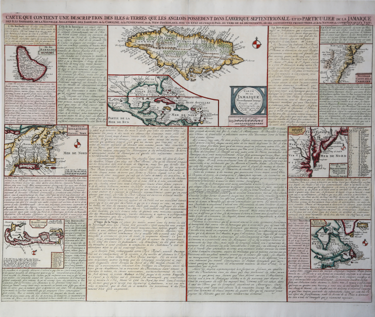
An attractive and interesting sheet from Chatelain's Atlas Historique depicting and describing British territorial claims in North America and the West Indies. New England, Virginnia, the Carolinas, Canada, Bermuda, and Barbados are all shown. A map of Jamaica takes pride of place front-and-center, with an inset map of the whole Caribbean. Each are accompanied by informative descriptions of the population, history, and produce of the territories depicted. Includes 8 maps, each of which would be highly coveted as a separate map. The maps include (1) a map of the Carolinas, (2) a map of the Chesapeake, (3) Canada and New England, (4) New England and New York, (5) Bermuda, (6) Barbados (7) Jamaica and (8) Florida. Also includes substantial explanatory text for the Gulf Coast, Mexico, Central America and the Caribbean.
Plate taken from "Atlas Historique".
Henri Abraham Chatelain (1684 - 1743) was a Huguenot pastor of Parisian origins. He is best known as a Dutch cartographer and more specifically for his cartographic contribution in the seminal seven volume Atlas Historique, published in Amsterdam between 1705 and 1720. Innovative for its time, the Atlas Historique combined fine engraving and artwork with scholarly studies of geography, history, ethnology, heraldry, and cosmography. Some scholarship suggests that the Atlas Historique was not exclusively compiled by Henri Chatelain, as is commonly believed, but rather was a family enterprise involving Henri, his father Zacharie and his brother, also Zacharie.
Copper engraving, with fine later hando colour, in excellent condition.
Henri Abraham CHATELAIN (1684 - 1743)
|
Henri Abraham Chatelain (1684 - 1743) was a Huguenot pastor of Parisian origins. He is best known as a Dutch cartographer and more specifically for his cartographic contribution in the seminal seven volume Atlas Historique, published in Amsterdam between 1705 and 1720. Innovative for its time, the Atlas Historique combined fine engraving and artwork with scholarly studies of geography, history, ethnology, heraldry, and cosmography. Some scholarship suggests that the Atlas Historique was not exclusively compiled by Henri Chatelain, as is commonly believed, but rather was a family enterprise involving Henri, his father Zacharie and his brother, also Zacharie. The Atlas Historique published by Chatelain was part of a major work of its time, an encyclopaedia in seven volumes including geography as one of its main subjectes. The text was by Nicholas Gueudeville and the maps by Chatelain. The Atlas included one of the finest maps of America (4 sheets) surrounded by vignettes and decorative insets.
1705-20 Atlas Historique:Amsterdam (maps by Chatelain based on G.Delisle)
Further issues to 1739
|