
| Reference: | S42565 |
| Author | Antonio ZATTA |
| Year: | 1776 |
| Zone: | Northwest Passage |
| Printed: | Venice |
| Measures: | 415 x 320 mm |
| Reference: | S42565 |
| Author | Antonio ZATTA |
| Year: | 1776 |
| Zone: | Northwest Passage |
| Printed: | Venice |
| Measures: | 415 x 320 mm |
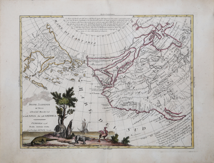
Striking example of Zatta's map of the northern Pacific Coastal regions and one of the best illustrations of a late rendition of the Northwest Passage, here illustrating two wide passages from the Pacific to Hudson's Bay, based upon the mythical voyages of Admirals Cluny and de Font.
The map depicts the Northwest coast of North America and Northeast coast of Asia and utilizes the Russian discoveries reported by J.N. De L'Isle. The map is noteworthy for the odd archipelago of islands off NE Asia, the rivers extending from the Pacific Coast to the interior of North America and the odd projection of the western coast of North America.
This conical projection shows the western coast of North America from the Baja Peninsula, along the coast of California to Alaska and thence to the Bering Strait and the Kamchatka Peninsula. The map is filled with hypothetical cartography based on misunderstood or mythical reports about the northern Pacific shores. Alaska is represented by a group of islands clustered off the coast of Russia, and the northwest coast of North America is filled with the fictitious system of rivers and lakes of the mythical Northwest Passage and discoveries of Admiral de Fonte. The map shows locations of ethnic groups and communities, and mentions the legendary Quivara (an alternative name for southwestern North America). Canada is broadly conceived, with waterways across the north related to the search for a Northwest Passage. The erroneous belief that that Chinese mariners colonized America in the late 5th Century led to the mythical "Fou-Sang" (colony of the Chinese) and the so-called Straits of Anian noted on the map in what is now Vancouver, British Columbia. Wagner declares the map to be "A Vaugondy mixture of old and new names as far south as the end of the peninsula."
All of this unscientific mapmaking would change quickly in the ensuing decades, as cartography benefited from a large number of expeditions in Arctic latitudes, beginning with the great English circumnavigator James Cook.
As with many maps by the famous mapmaker, the large decorative title vignette dominates. The pictorial cartouche includes a mythical desert island on which live several incongruent animals, all more suited to tropical climates - a crocodile, an elephant, a rhinoceros and an ostrich. The ship depicted in the vignette almost certainly is Captain Cook's ship, the Endeavour.
Map from the Atlante novissimo, illustrato ed accresciuto sulle osservazioni e scoperte fatte dai più celebri e più recenti geografi. Printed in four volumes by Antonio Zatta between 1779 and 1785.
Atlas among the most beautiful and complete ever published in Italy in the eighteenth century, the most famous work of Zatta.
The Atlante Novissimo, as also specified in the title, is “increased on the observations made by the most famous and most recent geographers”. Among the most significant innovations there is the appearance of the new islands discovered in the Pacific Ocean by James Cook and the first Italian map of New Zealand. The illustrations were designed and drawn by his collaborators Giovanni Marco Pitteri, Anton Friedrich Busching, Pietro Antonio Novelli and engraved by Giuliano Zuliani.
The first volume of the atlas is introduced by a brief essay of general geography where the author defines in a concise and precise way the elements that make up the ecliptic and equatorial grids used in the tables. Interesting is the section where he pauses to describe the phenomenon of precession of the equinoxes and the cyclical variation of the obliquity of the ecliptic.
Etching, printed on contemporary laid paper, contemporary outline coloring, in good condition.
Antonio ZATTA (Venezia 1722 - 1804)
|
Antonio Zatta (1775-1797) was the most prominent Italian map publisher of the late 18th and early 19th century. His firm, based in Venice, produced maps that mark an important transition from 18th to 19th century cartographic styles. He updates and redefines the traditional title cartouche by replacing the mythic elements common to the 17th and 18th century with more representative images of Venice. His most important work is the four volume Atlante novissimo published from 1775 to 1789.
|