| Reference: | s34308 |
| Author | Donato BERTELLI |
| Year: | 1570 ca. |
| Zone: | Naples |
| Printed: | Venice |
| Measures: | 525 x 385 mm |
| Reference: | s34308 |
| Author | Donato BERTELLI |
| Year: | 1570 ca. |
| Zone: | Naples |
| Printed: | Venice |
| Measures: | 525 x 385 mm |
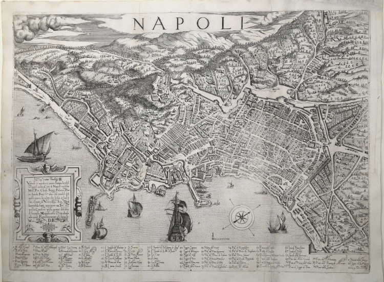
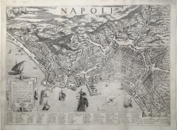
The map of Naples by Donato Bertelli represents a faithful derivation of the model introduced by Duperac-Lafreri in 1566. Therefore, it is a Venetian replica, on a larger scale, to be printed on a single copperplate. The proof that Bertelli completely resumes the work of Duperac is in the legend at the bottom, where the errors of the model are repeated. The dating can be traced back to the period 1570-75, but we believe that it precedes the map by Franz Hogenberg, published in Civitates Orbis Terrarum edited in Antwerp in 1572.
Lower left corner in a cartouche: " Ill.mo Sig.or Vicentio Pincelli. Volendo io mandare a nuova stampa la nobil & gentil vostra Città di Napoli con li suoi Moli, Porti, Chiese, Seggi, Palazzi, Piazze, Strade, Fonti, & altre cose notabili di quella pattia, ho voluto che la sia in luce sotto il nome di Vostra Ill.ma Sig.ria Qual havendola fatta imprimere un Ser.re di quella Conoscer possa quanto desidera di servirla Magnificarla & exaltarla alla quale Reverentemente gli bacia le Mani. D.B. Under the map a key-legend, 13 columns, with reference numbers, 1-74.
“La pianta di Napoli, incisa a Roma nel 1566 da Étienne Dupérac presso la bottega di Antonio Lafreri, è il primo vero monumento topografico della città di Napoli e si inserisce a pieno titolo, sia per le qualità tecniche, sia per quelle artistiche, nel più ampio scenario dell’iconografia urbana europea del Cinquecento. Per due secoli, è stata considerata la migliore rappresentazione di Napoli: realizzata con grande rigore geometrico, è la prima ad essere basata su un preciso rilievo topografico – non noto, probabilmente effettuato con il patrocinio della Corona Spagnola o del viceré Pedro de Toledo. Questa veduta a volo d’uccello restituisce in maniera puntuale il volto della città cinquecentesca sotto il regno di Filippo II, costituendo in tal modo un prezioso documento dello sviluppo urbano seguito alle iniziative promosse da don Pedro de Toledo, autore dell’ultimo progetto pubblico di ristrutturazione urbanistica a Napoli. L’immagine è realizzata con grande precisione e dovizia di particolari, attraverso la rappresentazione tridimensionale delle architetture cittadine, tanto da diventare un prototipo per gli incisori ed editori per tutto il Seicento. Una grande attenzione è data alla rappresentazione del circuito murario che costituisce la maggiore realizzazione/opera urbanistica a Napoli fino all’Ottocento. Molto ricco l’apparato decorativo, con un cartiglio a cornice barocca e numerose imbarcazioni in mare e nel porto. Tra le peculiarità della carta vanno rimarcate la scala elevata (1:5110 ca) e la sua continuità in ogni parte del disegno, ad eccezione delle prospettive paesaggistiche verso i Campi Flegrei. La pianta, quindi, proviene da un poderoso rilevamento topografico, forse appoggiato anche ad una triangolazione geometrica, tecnica già nota all’epoca. Nella parte inferiore del foglio è incisa la legenda con 74 rimandi (in effetti 75 in quanto il numero 41 è ripetuto due volte). Le acque del porto e della costa sono animate da numerose e varie imbarcazioni. Una ricca cornice decora il cartiglio presso il margine sinistro. Di grande utilità per la lettura e l’interpretazione della pianta è il contemporaneo volume di Giovanni Tarcagnota, Del sito, et lodi della città di Napoli... pubblicato postumo (Napoli, Giovanni Maria Scotto, 1566). Quest’opera contiene un’accurata descrizione, concepita sotto forma di dialogo, nella quale si fornisce un itinerario urbano sviluppato per motivi architettonici: le fontane, i pozzi, i seggi, i castelli. L’intento del Tarcagnota di illustrare la città trova piena rispondenza proprio nella coeva pianta di Lafreri-Dupérac” (cfr. Bifolco-Ronca, Cartografia e Topografia Italiana del XVI secolo, p. 2248).
Magnificent example, with margins, small folds, in good condition.
A very rare map; only 9 institutional example are known: Firenze, Marucelliana; Greenwich, National Maritime Museum; Londra, British Library; Modena, Biblioteca Estense; Monaco di Baviera, Bayerische StaatsBibliothek; Parigi, Bibliothèque Nationale; Roma, Casanatense; Vilnius, University Library; Wolfegg, Bibliothek Schloss.
Bibliografia
Bifolco-Ronca, Cartografia e Topografia Italiana del XVI secolo, p. 2253, tav. 1156; Meurer (2002): n. 185; National Maritime Museum (1971): n. 150; Ruge (1904-16): IV, n. 87.72; Tavernari (2014): n. 96; Pane-Valerio (1988): pp. 60-61, n. 13; Tooley (1939): n. 410; Valerio (1998): n. 13.
Donato BERTELLI (Attivo a Venezia seconda metà del XVI secolo)
|
Bertelli family represents the largest group of publishers, engravers, cartographers and merchants of prints of the sixteenth century. Ferrando Bertelli was the most productive, active between 1570, the 1560th, but maps of the last quarter of the century are known by the names of Andrea, Donato, Lucca, Nicholas and Peter. This was mainly active in Padua, where he led a workshop in letterpress and engravings. The earliest records show the asset at the date of 1589 as an engraver of several plates for an edition entitled Diversarum nationum habitus which was published in collaboration with Alciato Alciati. Pietro Bertelli had a library in Padua "the banner of the Angel". At his death the business was inherited by his son Francis. Donato Bertelli was printer, publisher and print dealer, was probably born in Padua, as is made clear by some of its branches ("Donatus Bertellius Patavinus") but active in Venice between 1563 and 1574, although it tends to expand its activities 1558 to 1592 on the basis of cartographic material marketed by him in those years. He worked in the workshop of Ferdinando Bertelli - with which it is not yet clear to the family relationship - from whom he inherited the branches etching, substituting his own name. As a publisher chalcographer emerged from his workshop papers invention or derivation Christmas Bonifacio, Giacomo Gastaldi, Ortelius etc.. In view of the large number of cards he initialed the Almagia him as "the principal heir and successor of the most active producers in the second half of the sixteenth century" in Venice. His successor "to the book publishing of St. Mark" was Andrea, who always used the old branches of Donato. Bibliography: Valerio, Cartographers Veneti, p. 149.
|