
| Reference: | VR30OL |
| Author | Johannes LOOTS |
| Year: | 1700 |
| Zone: | Mediterranean Sea |
| Printed: | Amsterdam |
| Measures: | 1200 x 525 mm |
| Reference: | VR30OL |
| Author | Johannes LOOTS |
| Year: | 1700 |
| Zone: | Mediterranean Sea |
| Printed: | Amsterdam |
| Measures: | 1200 x 525 mm |
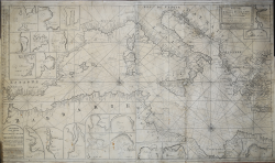
Nouvelle Carte Marine de la Partie d’Orient et d’Occident de la Mediterranée Avec la d’Escription des Principales Havres, Bayes, Rades, et emrages, en grand Point, le tout étables Par leur veritables Latitudes Marqué Par le Sieur Berthelot professeur D’Hydrographe à Marseille. Ce vendens che Iean Loots Marchant Librarie de Cartes et Autres Instruments de Marine pour les Ingenieurs et Canonniers, demeurant dans le Petit Rue de Pont Neuf à Amsterdam = Nieuwe Pas-kaart van ‘t Westelyckste deel der Middelantsche Zee met de Voor-naamste Havens alles gelegt op zyn Behoorlyke Breete tot Amsterdam by Ioannes Loots Boek Zeekart Verkooper en Graadboogmaaker inde Nieuwebrugsteeg inde Ionge Lootsman & Paskaart Van de Zee-kusten van Italie, Dalmatie, Sicilia, Grecia, Morea Malte en Candie Met de voornaamste Havens Int Groot Nooit voor dase Soo Gesien. ‘t Amsterdam by Ioannes Loots.
Etching and engraving, respectively 605x525 mm (western part) and 600x530 mm (eastern part).
Good proof, printed on two sheets of contemporary laid paper, with thin margins, some perfectly executed restorations, overall in good condition. Example with traces of wear, probably due to use in navigation.
Extremely rare Mediterranean portolan by Johannes Loots. Title in French and Dutch, in the cartouche, at lower left, in western part; only in Dutch in the cartouche at upper right in the eastern part. On both cartouche the imprint: tot Amsterdam by Ioannes Loots Boek Zeekart Verkooper en Graadboogmaaker inde Nieuwebrugsteeg inde Ionge Lootsman.
It depicts the coastlines of large part of the Mediterranean Sea, from Gibraltar till the island of Creta, and also a small portion of the Atlantic in the approaches to Gibraltar. Very accurate description of the sea locations and, in the landside, detailed description of 20 important ports. In the lower left corner a cartouche in French: "Nouvelle Carte marine de la partie d'Orient et d'occident de la Mediterranee..." by Berthelot, professor in Marseille.
Only a few of Johannes Loots'sea charts have survived to modern times, mostly because they were used by mariners at sea. Johannes Loots (1665 - 1726) was active from 1693 until his death in 1726. Loots began his career by Hendrick Doncker. Several charts from this maker were offered separately.
In 1707, Loots sold 100 charts to Gerard Van Keulen. In 1707, Loots seems to have purchased the plates of Jacob Robijn.
Bibliografia: C. Koeman, Atlantes Neerlandici: Bibliography of Terrestrial, Maritime and Celestial Atlases and Pilot Books Published in the Netherlands up to 1880 Vol. IV, pp. 409-421, Lts 2, (114, 115).
|
S. Bifolco, "Mare Nostrum, Cartografia nautica a stampa del Mar Mediterraneo" (2020), pp. 162-163, tav. 70.
|
Johannes LOOTS (1665 ca. - 1726)
|
A mathematical and nautical instrument maker, Loots also published manuals on navigation.
For a time he was in partnership with an engraver, A de Winter, and an author of text books on charts, Claes de Vries, who had ambitions to publish a very large sea atlas of some 200 charts but this was never completed on the scale contemplated.
Some of their charts were sold to Gerard van Keulen and others were used in a sea atlas published in 1697.
Charts by Loots also appear in a number of other pilot books and sea atlases of the time.
|
|
S. Bifolco, "Mare Nostrum, Cartografia nautica a stampa del Mar Mediterraneo" (2020), pp. 162-163, tav. 70.
|
Johannes LOOTS (1665 ca. - 1726)
|
A mathematical and nautical instrument maker, Loots also published manuals on navigation.
For a time he was in partnership with an engraver, A de Winter, and an author of text books on charts, Claes de Vries, who had ambitions to publish a very large sea atlas of some 200 charts but this was never completed on the scale contemplated.
Some of their charts were sold to Gerard van Keulen and others were used in a sea atlas published in 1697.
Charts by Loots also appear in a number of other pilot books and sea atlases of the time.
|