- New

| Reference: | S50964 |
| Author | Eredi Johannes Baptiste HOMANN |
| Year: | 1755 |
| Zone: | Rome |
| Printed: | Nurnberg |
| Measures: | 950 x 700 mm |
| Reference: | S50964 |
| Author | Eredi Johannes Baptiste HOMANN |
| Year: | 1755 |
| Zone: | Rome |
| Printed: | Nurnberg |
| Measures: | 950 x 700 mm |
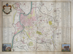
Geometric plan with elevation, published in Nuremberg by the printing hose of Johannes Baptiste Homann's heirs in 1755. It is a reworking, without any updating, of the important relief by Leonardo Bufalini (1551), brought back by Giovan Battista Nolli in 1748. The key-legend of 307 references in Latin is taken from Nolli's reduction, and demonstrates its direct derivation. However, the map of the Homann heirs, printed on four sheets and therefore larger in size, is much more clear.
Leonardo Bufalini's map of Rome is the first coherent representation of the city and the most important orthogonal representation up to the large plan by Giambattista Nolli (1748). Bufalini took care of all the phases of its realization, from relief to engraving, using a long time: seven years, according to Onofrio Panvinio, twenty according to the publisher Antonio Trevisi. The Map of Rome was printed at the typographer Antonio Blado on May 26, 1551 in Rome, with the ten-year privilege of the Republic of Venice and dedicates it to Charles V and Pope Julius III. It is a monumental work: a woodcut in twelve sheets and four lateral strips.
Although the map is based on reliefs made by the author, there is no lack of elements of fantasy: many ancient monuments have been added, completed and rebuilt freely.
The primary source used by Bufalini is Bartolomeo Marliano's ancient Rome, inserted in his Urbis Romae Topographia, which has the same orientation and the same precision in detail. Since its publication in 1551, Bufalini's map exerted a notable influence on the subsequent plans of the city until 1748, the year in which Giambattista Nolli published a reduced copy together with his large plan, which became the new model.
Johann Baptist Homann was a German geographer and cartographer; in 1702 he founded his own publishing house. Homann acquired renown as a leading German cartographer, and in 1715 was appointed Imperial Geographer by Emperor Charles VI. In the same year he was also named a member of the Prussian Academy of Sciences in Berlin. In 1716 Homann published his masterpiece Grosser Atlas ueber die ganze Welt; numerous maps were drawn up in cooperation with the engraver Christoph Weigel the Elder. Homann died in Nuremberg in 1724 and was succeeded by his son Johann Christoph (1703-1730). The company carried on upon his death as Homann heirs company, managed by Johann Michael Franz and Johann Georg Ebersberger. After subsequent changes in management the company folded in 1852.
Etching, 4 plates 495x365 mm each, printed on as many sheets of coeval laid paper, in perfect condition.
Literature
Huelsen (1915), no. 3; Scaccia Scarafoni (1939), n. 136; Marigliani (2007): n. 32.
Eredi Johannes Baptiste HOMANN (1730 - 1813)
|
Johann Baptist Homann (20 March 1664 – 1 July 1724) was a German geographer and cartographer
born in Oberkammlach near Kammlach in the Electorate of Bavaria. Although educated at a Jesuit school, and preparing for an ecclesiastical career, he eventually converted to Protestantism and from 1687 worked as a civil law notary in Nuremberg. He soon turned to engraving and cartography; in 1702 he founded his own publishing house. Homann acquired renown as a leading German cartographer, and in 1715 was appointed Imperial Geographer by Emperor Charles VI. Giving such privileges to individuals was an added right that the Holy Roman Emperor enjoyed. In the same year he was also named a member of the Prussian Academy of Sciences in Berlin. Of particular significance to cartography were the imperial printing privileges (Latin: privilegia impressoria). These protected for a time the authors in all scientific fields such as printers, copper engravers, map makers and publishers. They were also very important as a recommendation for potential customers. In 1716 Homann published his masterpiece Grosser Atlas ueber die ganze Welt (Grand Atlas of all the World). Numerous maps were drawn up in cooperation with the engraver Christoph Weigel the Elder, who also published Siebmachers Wappenbuch. Homann died in Nuremberg in 1724. He was succeeded by his son Johann Christoph (1703-1730). The company carried on upon his death as Homann heirs company, managed by Johann Michael Franz and Johann Georg Ebersberger. After subsequent changes in management the company folded in 1852. The company was known as "Homann Erben", "Homanniani Heredes", or "Heritiers de Homann" abroad.
1702-07 Atlas novus terrarum
1712 Enlarged edition with re-issues to c.1753
c.1714 Neuer Atlas
re-issues to c. 1730
1719 Atlas Methodicus
1730 America Septentrionali Britannorum
1737 Grosser atlas
re-issues to c. 1770
|