
| Reference: | A53163 |
| Author | Anonimo |
| Year: | 1700 ca. |
| Zone: | Rome |
| Printed: | Paris |
| Measures: | 200 x 165 mm |
| Reference: | A53163 |
| Author | Anonimo |
| Year: | 1700 ca. |
| Zone: | Rome |
| Printed: | Paris |
| Measures: | 200 x 165 mm |
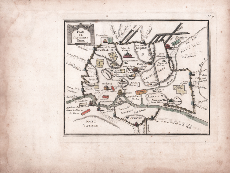
An extremely rare map of ancient Rome, unknown to the repertoire, published in Paris between the late 17th and early 18th centuries.
It is based on the model by the Jesuit Philippe Briet, published in Parallela Geographica Italiae veteris et novae in 1649, which Caldana describes: "The plan can be defined as a personal and partly imaginative reworking of previous models, with an extravagant design of the Aurelian Walls and the aqueducts—sometimes zigzagging, sometimes too straight—with an exaggerated Janiculum circuit and the survival of a tiny 'Vivarium.'" Also questionable are the course of the Tiber with Tiber Island and the orography, which features an enormous Monte Celio and a tiny Quirinale, while in place of the Capitoline Hill there is a strange 'M. Tarplivs' (for "Tarpeivs"), and the very wide consular roads sometimes branch out like fans. A bizarre yet charming map, with north to the left and the title in the upper left corner within a graceful cartouche” (see Alberto Caldana, Roma Antica, p. 90).
Compared to Briet's model, the cartouche at the top right is different.
Etching, contemporary coloring, in excellent condition.
Anonimo
Anonimo