| Reference: | A53375 |
| Author | Nicolas DE FER |
| Year: | 1700 |
| Zone: | Rome |
| Printed: | Paris |
| Measures: | 310 x 240 mm |
| Reference: | A53375 |
| Author | Nicolas DE FER |
| Year: | 1700 |
| Zone: | Rome |
| Printed: | Paris |
| Measures: | 310 x 240 mm |
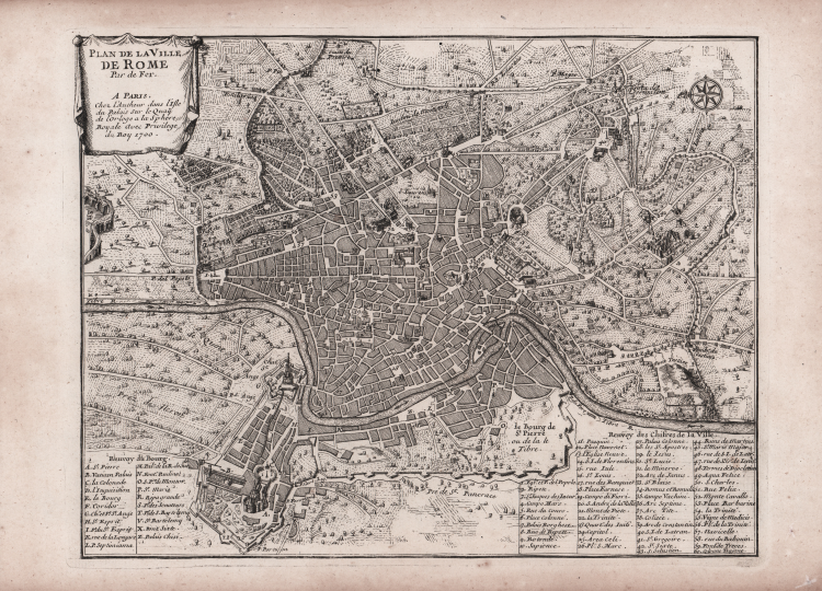
Detailed plan of Rome, from De Fer's Atlas Curieux.
“Questa pianta è nota soprattutto nella seconda edizione che è molto comune e porta la data 1705. La città è raffigurata in pianta con i lotti campiti a tratteggio e le emergenze architettoniche ritratte in alzato. Forse la grande pianta del De Rossi servì in parte da modello per questa assai più piccola che mostra comunque una apprezzabile originalità grafica e la cui asciuttezza bene inaugura lo spirito del nuovo secolo. In basso 60 numeri di legenda in francese. Curiosamente sembra ancora raffigurato il tratto di colonnato che doveva chiudere la piazza sul lato opposto alla Basilica. La ridotta scala di rappresentazione del disegno non consente di verificare quanto la pianta sia aggiornata ed in particolare se riporti gli interventi di Innocenzo XII” (cf. Marigliani, p. 258).
Nicholas de Fer (1646-1720) was the son of a map seller, Antoine de Fer, and grew to be one of the most well-known mapmakers in France in the seventeenth century. He was apprenticed at twelve years old to Louis Spirinx, an engraver. When his father died in 1673, Nicholas helped his mother run the business until 1687, when he became the sole proprietor. In 1697, he published his first world atlas. After his death in 1720, the business passed to his sons-in-law, Guillaume Danet and Jacques-Francois Benard.
A fine example.
Bibliografia
Huelsen n. 131a; Marigliani, Le piante di Roma, p. 254, n. 16; Scaccia Scarafoni n. 212.
Nicolas DE FER (1646-1720 circa)
|
One of the most prolific and influential French geographers and cartographers of the late 17th and early 18th Century. Nicolas was the youngest son of Parisian print and mapseller, Antoine de Fer [d.1673]. He produced numerous atlases: Atlas Curieux [1700-5] and its subsequent suites; Atlas ou Receuil des Cartes [1709]; Atlas Royale [1699]; Les Beautés de la France [1708]; Atlases detailing wars and countries relating to the Spanish succession [1701]; Italy [1702] & Germany [1705] and Franco-Belgian frontiers [1708-10]; Les Forces de L'Europe [1690-95]; Introduction à la Géographie [1708]; the Petit Nouveau Atlas [1697]. Aswell as his Atlas output de Fer is also well known for his large Wall maps, some 26 in total, aswell as large-scale town plans of European cities, and a signifcant output of thematic printed card games. His sign and emblem was the Sphère Royale, originally that of Melchior Tavernier, to which he was greatly attached and which appears on a large number of his works. He died on 25th October 1720 and his estate was divided between his three daughters, all three of whose husbands were closely involved in the Parisian engraving and publishing business : Guillaume Danet, Remi Richer, Jaques-Francois Besnard or Bénard. A number of de Fer's maps and atlases continued to be published by his heirs for another twenty or thirty years.
|