

| Reference: | A51953 |
| Author | Giambattista NOLLI |
| Year: | 1748 |
| Zone: | Roma |
| Printed: | Rome |
| Measures: | 1660 x 1410 mm |
| Reference: | A51953 |
| Author | Giambattista NOLLI |
| Year: | 1748 |
| Zone: | Roma |
| Printed: | Rome |
| Measures: | 1660 x 1410 mm |
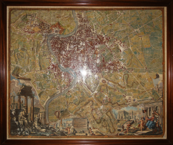
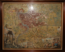
The "Nuova Pianta di Roma data in luce da Giambattista Nolli" is a monumental map of Rome considered a masterpiece of eighteenth-century cartography. Consisting of twelve copper-engraved sheets, the work offers an extremely detailed survey of the city and became a fundamental tool for land management and the study of Rome.
Published in 1748 (dedicated to Pope Benedict XIV), it is the result of work by Giovan Battista Nolli between 1736 and 1748.
The work was commissioned from Giovan Battista Nolli in the 1740s by Abbot Diego de Revillas, around whom an association of scholars, mathematicians, and antiquarians in Rome gravitated. With this undertaking, Rome acquired an updated and rationally conceived map using modern scientific surveying instruments. Nolli's plan, in fact, was intended to meet the specific need to establish, in keeping with Enlightenment-inspired urban planning thinking, a fundamental document for the management of the city's territory, suited to the structures of modern European capitals. The engraving was executed by Giuseppe Vasi, Rocco Pozzi, Pietro Campana, and Carlo Nolli, based on a design by Giovan Battista Nolli, Giovanni Paolo Pannini, and Stefano Pozzi.
Nolli's plan departs from traditional bird's-eye views, presenting a scientifically precise ground-level perspective, grounded in Enlightenment ideals of reason and empirical measurement. Commissioned in 1736 with the support of influential patrons, Nolli, an established engineer and architect from Como, led a dedicated team in a decade-long survey of Rome, using new instruments and accessing public and private property for precise measurements. This method ensured that Nolli's plan surpassed previous ones, avoiding inherited inaccuracies and depicting the city's layout with unprecedented precision.
In particular, Nolli innovatively illustrated urban space in what is now known as the "figure-ground" style: public spaces such as streets, squares, and church interiors are unshaded, indicating free access, while private buildings are shaded, indicating restricted areas. This shading contrast was revolutionary, effectively representing the accessibility of Rome's public areas and defining its urban form with clarity and distinction.
The lower section of the map is adorned with an elaborate cartouche designed by artist Stefano Pozzi, who collaborated closely with Nolli. The composition captures the grandeur of Rome, incorporating ancient monuments, including the Colosseum, Trajan's Column, and the Arch of Constantine, along with allegorical figures representing the legendary founders, Romulus and Remus. On the opposite side, an allegory of the Church is positioned, seated before Michelangelo's structures on the Capitoline Hill, symbolizing the union of Rome's spiritual and architectural heritage. Pozzi's work captures the Baroque sensibility, adding a visual narrative that complements Nolli's scientific rigor.
The importance of the Nuova Pianta extends beyond its artistic merits. This is the first map of Rome created using geodetic principles, marking a turning point in urban cartography. Nolli's surveys allowed him to calculate distances and angles with unparalleled precision, offering insights into Rome's topography and infrastructure. The plan's scale and detail not only guided urban development but also became a reference for architects, scholars, and urban planners for centuries.
Etching, finely hand-colored, applied to canvas and mounted, enclosed in a 20th-century walnut frame. Shipping costs are calculated based on destination.
Bibliografia
Frutaz, Le Piante Di Roma, V. 1, p. 234; Maier, The Eternal City, page 138.
Giambattista NOLLI (Como 1701 - Roma 1756)
|
Giambattista Nolli was an Italian architect and surveyor. He is best known for his ichnographic plan of Rome, the Pianta Grande di Roma which he began surveying in 1736 and engraved in 1748, and now universally known as the Nolli Map. The map is composed of 12 copper plate engravings that was published in response to the commission of Pope Benedict XIV to survey Rome in order to help create demarcations for the 14 traditional rioni or districts. It was by far the most accurate description of Rome produced to date at a time when the architectural achievement of the Papacy was in full flower.
|