| Reference: | S38990 |
| Author | Giovanni Antonio MAGINI |
| Year: | 1597 |
| Zone: | Liguria |
| Printed: | Bologna |
| Measures: | 485 x 350 mm |
| Reference: | S38990 |
| Author | Giovanni Antonio MAGINI |
| Year: | 1597 |
| Zone: | Liguria |
| Printed: | Bologna |
| Measures: | 485 x 350 mm |
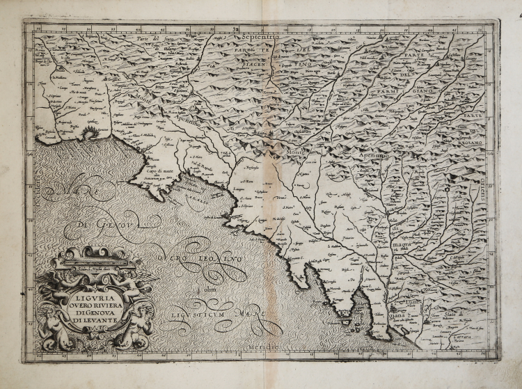
RARISSIMA PRIMA REDAZIONE DELLA "RIVIERA DI LEVANTE" di Giovanni Antonio Magini.
Acquaforte e buino, 1597, priva di dati editoriali. Incisa da Arnoldo di Arnoldi per Giovanni Antonio Magini (senza data ma 1597).
Si tratta della prima versione - definita redazione da R. Almagià - della carta della Liguria orientale del Magini, MAI PUBBLICATA nell'atlante maginiano, edito postumo dal figlio Fabio nel 1620, nella quale fu sostituita dalla seconda versione - o redazione - incisa nel 1608-9 dall'inglese Benjamin Wright.
Per la descrizione ci affidiamo a ciò che scrive Roberto Almagià nel suo saggio sull'opera maginiana del 1922:
"Le carte del Piemonte e della Liguria in generale debbono essere considerate insieme, perché riposano di materiali comuni. […] per tali carte il Magini ebbe i materiali ed eseguì il lavoro in due epoche diverse ed assai lontane: una prima volta nel 1597 (e forse in parte ancora l'anno prima) e una seconda volta, oltre dieci anni dopo, nel 1608-9. Come risulta anche dall'elenco del 1604, la prima volta egli mise insieme due carte delle due Riviere e tre carte del Piemonte; la seconda volta rifece le due carte della Liguria, sostituendole alle vecchie, e fece una nuova carta del Piemonte. […] le due tavole della Liguria della più vecchia redazione, che il Magini ha eliminato dall'Atlante, ci sono tuttavia rimaste, ed, essendo finora sfuggite alla attenzione degli studiosi […] La vecchia "Riviera di Genova di Occidentale ha la dedica di G. A. Magini ad Orazio Bracelli in data 15 ottobre 1597"; la vecchia "Riviera di Genova di Levante" non ha dedica né data. Entrambe sono pure di mano dell'Arnoldi, e la prima è anzi una continuazione verso sud dello "Stato del Piemonte". […] Anteriormente all'anno 1597, che si può ritenere come data di redazione di questo gruppo di carte, esistevano già parecchie carte a stampa del Piemonte, taluna delle quali comprendenti anche parte della Liguria; nessna carta, né a stampa né manoscritta, è a me comoscuta delle Riviere, epperò le due carte maginiane dovrebbero essere le più antiche conosciute".
Sempre Almagià aggiunge (ibid. nota 1 p. 24): "Le due carte sono estremamente rare. Di quella della Riviera di Ponente, io ebbi notizia per la prima volta dal Dott. Edward E. Berry, che ne possiede due copie, una sciolta, l'altra inserita in un esemplare dell' "Italia" del 1620, al posto della corrispondente nuova. La carta della Riviera di Levante, fu ritrovata da me, pur essa in qualche esemplare (bonomiano) dell' "Italia" del 1620, al posto della nuova".
Magnifico esemplare, con margini, leggera traccia di colla alla piega centrale, per il resto in eccellente stato di conservazione. Prima carta a stampa della regione.
|
Almagià, L'Italia di Giovanni Antonio Magini e la Cartografia dell'Italia nei secolo XVI e XVII (1922), pp. 23-29, Tav. II.
|
Giovanni Antonio MAGINI (1555 - 1617)
|
Giovanni Antonio Magini was born in Padua in 1555, dedicating himself to the study of astronomy from an early age. In 1588 the Senate of Bologna appointed him Lecturer of Astronomy at the local University, choosing him instead of Galileo Galilei. His friendship with the Duke of Mantua, Vincenzo Gonzaga, helped Magini in his quest to obtain cartographical material for map-making from the various sovereigns ruling the different Italian states at that time. Because of Magini's early death in 1617, this effort was made famous by his son Fabio when he published the atlas "L'Italia" in Bologna in 1620. This is the first example of an Italian atlas and is made up of 24 pages of descriptive text and 61 maps of the Italian peninsula. Although this work was published posthumously, it can be entirely ascribed to Magini. He began drawing this maps around 1594, with the one depicting Bologna and its surrounding territories being the first. They were all printed before 1620 in draft editions which were then revised and updated for the final version. These draft proofs are extremely rare, although sometimes available for sale, and exhibit substantial differences in respect to the maps finally included in the atlas. Two of the most famous engravers of the time, Arnoldo Arnoldi and the englishman Benjamin Wright, were entrusted by Magini to engrave the plates. As we shall see in the presentation of the separate maps, they derive from different sources, both known and unknown, and therefore represent the result of an original work of critical analysis and compilation. This atlas had an important influence on the cartography of the italian peninsula for the following two centuries, beginning from Ortelius and going on to the principal dutch cartographers and editors.
|
|
Almagià, L'Italia di Giovanni Antonio Magini e la Cartografia dell'Italia nei secolo XVI e XVII (1922), pp. 23-29, Tav. II.
|
Giovanni Antonio MAGINI (1555 - 1617)
|
Giovanni Antonio Magini was born in Padua in 1555, dedicating himself to the study of astronomy from an early age. In 1588 the Senate of Bologna appointed him Lecturer of Astronomy at the local University, choosing him instead of Galileo Galilei. His friendship with the Duke of Mantua, Vincenzo Gonzaga, helped Magini in his quest to obtain cartographical material for map-making from the various sovereigns ruling the different Italian states at that time. Because of Magini's early death in 1617, this effort was made famous by his son Fabio when he published the atlas "L'Italia" in Bologna in 1620. This is the first example of an Italian atlas and is made up of 24 pages of descriptive text and 61 maps of the Italian peninsula. Although this work was published posthumously, it can be entirely ascribed to Magini. He began drawing this maps around 1594, with the one depicting Bologna and its surrounding territories being the first. They were all printed before 1620 in draft editions which were then revised and updated for the final version. These draft proofs are extremely rare, although sometimes available for sale, and exhibit substantial differences in respect to the maps finally included in the atlas. Two of the most famous engravers of the time, Arnoldo Arnoldi and the englishman Benjamin Wright, were entrusted by Magini to engrave the plates. As we shall see in the presentation of the separate maps, they derive from different sources, both known and unknown, and therefore represent the result of an original work of critical analysis and compilation. This atlas had an important influence on the cartography of the italian peninsula for the following two centuries, beginning from Ortelius and going on to the principal dutch cartographers and editors.
|